-
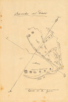
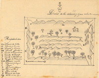
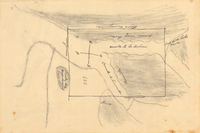
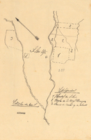
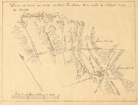
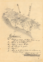
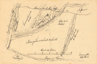
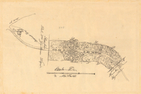
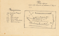
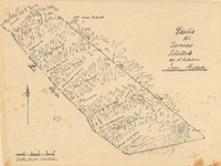
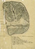 Cañada Larga o Verde Rancho
 Hand-drawn sketch map of Cañada Larga o Verde boundaries. Volume 2, page 5.
-
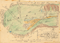
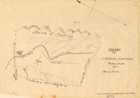
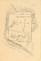
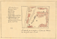
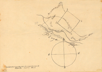
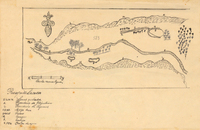
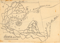
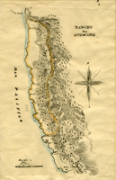
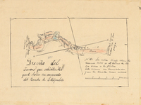
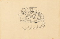
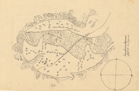
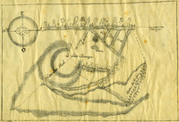 San Louis Gonzaga Rancho
 Hand-drawn sketch map of San Louis Gonzaga boundaries. Volume 1, page 1.
-
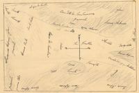
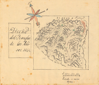
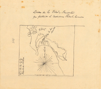
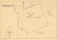
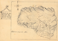
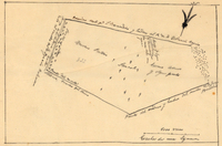
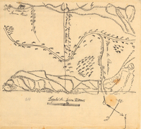
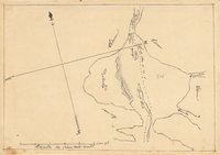
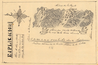 Nietos Addition Rancho
 Hand-drawn sketch map of Nietos Addition boundaries. Volume 2, page 205.
-
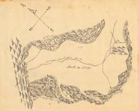
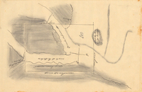
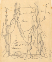
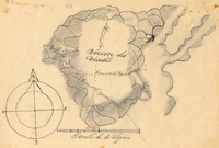
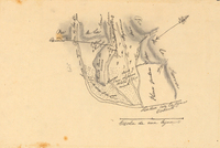
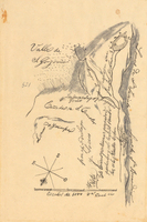
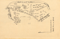
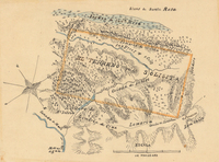
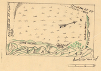 Cuyama or Cuyoma Rancho
 Hand-drawn sketch map of Cuyama or Cuyoma boundaries. Volume 2, page 204.
-
 Cuyama or Cuyoma Rancho
 Hand-drawn sketch map of Cuyama or Cuyoma boundaries. Volume 2, page 203.
-
 Cuyama or Cuyoma Rancho
 Hand-drawn sketch map of Cuyama or Cuyoma boundaries. Volume 2, page 202.
-
 Grulla Rancho
 Hand-drawn sketch map of Grulla boundaries. Volume 2, page 201.
-
 Valle de San Felipe Rancho
 Hand-drawn sketch map of Valle de San Felipe boundaries. Volume 2, page 200
-
 Alamos y Agua Caliente Rancho
 Hand-drawn sketch map of Alamos y Agua Caliente boundaries. Volume 2, page 199.
-
 Lomas de Santioago or Lomerias de Santiafo or Santiago Rancho
 Hand-drawn sketch map of Lomas de Santioago or Lomerias de Santiafo or Santiago boundaries. Volume 2, page 198.
-
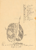
 Canada de los Alisos Rancho
 Hand-drawn sketch map of Canada de los Alisos boundaries. Volume 2, page 197.
-
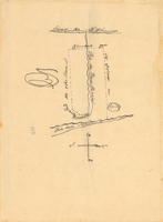
 Canada de la Berrenda Rancho
 Hand-drawn sketch map of Canada de la Berrenda boundaries. Volume 2, page 196.
-
 Canada de la Berrenda Rancho
 Hand-drawn sketch map of Canada de la Berrenda boundaries. Volume 2, page 195.
-
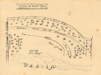
 Valle de la Trinidad Rancho
 Hand-drawn sketch map of Valle de la Trinidad boundaries. Volume 2, page 194.
-
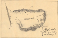
 Island of San Diego or Peninsula of San Diego or North Island Rancho
 Hand-drawn sketch map of Island of San Diego or Peninsula of San Diego or North Island boundaries. Volume 2, page 193.
-
 Chimiles Rancho
 Hand-drawn sketch map of Chimiles boundaries. Volume 2, page 192.
-
 Santa Rita Rancho
 Hand-drawn sketch map of Santa Rita boundaries. Volume 2, page 191.
-
 Land- Mission San Luis Obispo Rancho
 Hand-drawn sketch map of Land- Mission San Luis Obispo boundaries. Volume 2, page 190.
-
 Lot- Mission-San Gabriel Rancho
 Hand-drawn sketch map of Lot- Mission-San Gabriel boundaries. Volume 2, page 189.
-
 Rincon del Diablo Rancho
 Hand-drawn sketch map of Rincon del Diablo boundaries. Volume 2, page 188.
-
 San Diego or San Deiguito Rancho
 Hand-drawn sketch map of San Diego or San Deiguito boundaries. Volume 2, page 187.
-
 San Diego or San Deiguito Rancho
 Hand-drawn sketch map of San Diego or San Deiguito boundaries. Volume 2, page 186.
-
 Cañada Rancho
 Hand-drawn sketch map of Cañada boundaries. Volume 2, page 185.
-
 Muscupiabe Rancho
 Hand-drawn sketch map of Muscupiabe boundaries. Volume 2, page 184.
-
 Cañada de los Osos y Pecho y Islae Rancho
 Hand-drawn sketch map of Cañada de los Osos y Pecho y Islae boundaries. Volume 2, page 183.
-
 Cuyama Rancho
 Hand-drawn sketch map of Cuyama boundaries. Volume 2, page 182.
-
 Santa Ana del Chino Sobrante Rancho
 Hand-drawn sketch map of Santa Ana del Chino Sobrante boundaries. Volume 2, page 181.
-
 Land-San Jacinto y San Gorgonio or Yuciapa Rancho
 Hand-drawn sketch map of Land-San Jacinto y San Gorgonio or Yuciapa boundaries. Volume 2, page 180.
-
 Temescal Rancho
 Hand-drawn sketch map of Temescal boundaries. Volume 2, page 179.
-
 Guesesosi or Jesus Maria Rancho
 Hand-drawn sketch map of Guesesosi or Jesus Maria boundaries. Volume 2, page 178.
-
 Ojo de Agua del Encinal Rancho
 Hand-drawn sketch map of Ojo de Agua del Encinal boundaries. Volume 2, page 176.
-
 Land- Los Angeles Rancho
 Hand-drawn sketch map of Land-Los Angeles boundaries. Volume 2, page 175.
-
 Blosa del Chamizal Rancho
 Hand-drawn sketch map of Blosa del Chamizal boundaries. Volume 2, page 174.
-
 Cañada de Capay Rancho
 Hand-drawn sketch map of Cañada de Capay boundaries. Volume 2, page 177.
-
 Rincon de Musulacon Rancho
 Hand-drawn sketch map of Rincon de Musulacon boundaries. Volume 2, page 173.
-
 Cañada de Secuan or Mesa del Arroya or Valle de las Viejas Rancho
 Hand-drawn sketch map of Cañada de Secuan or Mesa del Arroya or Valle de las Viejas boundaries. Volume 2, page 171.
-
 Cañada del Rincon en el Rio San Lorenzo de Santa Cruz Rancho
 Hand-drawn sketch map of Cañada del Rincon en el Rio San Lorenzo de Santa Cruz boundaries. Volume 2, page 170.
-
 Rancho de German Rancho
 Hand-drawn sketch map of Rancho de German boundaries. Volume 2, page 172.
-
 Huefano Or Huer-huero Rancho
 Hand-drawn sketch map of Huefano Or Huer-huero boundaries. Volume 2, page 169.
-
 Land-Mission San Luis Obispo Rancho
 Hand-drawn sketch map of Land-Mission San Luis Obispo boundaries. Volume 2, page 168.
-
 Cañada de San Miguelito or Cañada del Diablo Rancho
 Hand-drawn sketch map of Cañada de San Miguelito or Cañada del Diablo boundaries. Volume 2, page 167.
-
 San Miguelito Addition Rancho
 Hand-drawn sketch map of San Miguelito Addition boundaries. Volume 2, page 166.
-
 Vallecitos Rancho
 Hand-drawn sketch map of Vallecitos boundaries. Volume 2, page 165.
-
 Cañada de Jonive Rancho
 Hand-drawn sketch map of Cañada de Jonive boundaries. Volume 2, page 164.
-
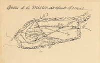 Santa Tomas Rancho
 Hand-drawn sketch map of Santa Tomas boundaries. Volume 2, page 163.
-
 Santa Rosa Rancho
 Hand-drawn sketch map of Santa Rosa boundaries. Volume 2, page 162.
-
 Santa Rosa Rancho
 Hand-drawn sketch map of Santa Rosa boundaries. Volume 2, page 161.
-
 Mission Vieja de San Rafael Rancho
 Hand-drawn sketch map of Mission Vieja de San Rafael boundaries. Volume 2, page 160.
-
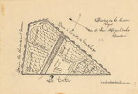
 Descanso at San Miguel Rancho
 Hand-drawn sketch map of Descanso at San Miguel boundaries. Volume 2, page 159.
-
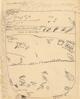
 Barona Rancho
 Hand-drawn sketch map of Barona boundaries. Volume 2, page 158.