-
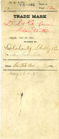 "Old Series" Trademarks
 This collection highlights California's early years of trademark filings under the state's Trademark Registration Act (Chapter 129, Statutes of 1863). California began registering certain container brands in 1861, but trademark registration for all types of products began in 1863, seven years prior to federal legislation. California was the first state in the Union to allow trademark registration, and today those doing business in California still register their trademarks with the Secretary of State.
The California State Archives, in conjunction with The Friends of California Archives, is pleased to unveil the results of a National Historical Publications and Records Commission (NHPRC) funded project. The NHPRC awarded The Friends of California Archives money to support “For Their Protection: Digitizing California's 19th Century Trademark Files,” a project to digitize approximately 24,000 pages from the collection of Trademark Registrations and Specimens, Old Series, 1861-1900 at the California State Archives. The results of that digitization project are displayed here.
Trademark applications or claims typically contain the filing date, a trademark specimen (a label, sketch, or facsimile), the name(s) of the applicant(s), the name of the company, and may include the business address, identification of product, and a detailed description of the trademark. Legitimate producers registered their trademarks in part as an effort to protect themselves and the public from those who sought to sell counterfeit merchandise. Often ephemeral and truly “signs of the times,” trademarks give us an idea of the types of products sold and consumed in California in the past and offer us a glimpse of life in the Golden State as it was in bygone days.
-
 William M. McCarthy Photograph Collection
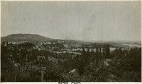
 Capturing the rich history of the early twentieth century, the William M. McCarthy Photograph Collection (Identification #96-07-08) highlights well-known landmarks, historic events, and scenic vistas from the Pacific Ocean to the Atlantic, from the Deep South to Canada, and from Mexico to Cuba. Scenes across the Golden State are captured in stunning shots from Lake Tahoe to Yosemite and the Central Coast to Southern California cities. The collection features nearly 3,000 photographs taken by native Californians William M. and Grace McCarthy from approximately 1905 to 1938. The McCarthys traveled extensively during the early years of automobile travel, as newly constructed highways connected people and places throughout the United States and beyond, providing pictorial documentation of a pivotal period in our nation's history.
William M. McCarthy (1876 – 1956) and Grace C. Kane (1878 – 1957) wed in the early 1900s and lived in San Francisco for most of their lives where William was stationed as an armament expert for the U.S. War Department. The collection features photographs of the McCarthys' travels, as well as the many family members and friends they encountered along the way. Always ready with his camera, William McCarthy also captured remarkable images of significant events, including shots of San Francisco before and after the 1906 earthquake, the fire that destroyed that city's iconic Cliff House in 1907, the 1915 Panama-Pacific International Exposition, and their 1938 journey into Mexico along the newly constructed Pan American Highway. The original black and white photographs, mounted in eleven albums, make up one of the few private collections preserved by the California State Archives. The entire collection was digitized by the State Archives' curatorial staff.
To request a high-resolution scan of one or more of these images, contact the California State Archives at ArchivesWeb@sos.ca.gov or (916) 653-2246. Please include the Title or Identifier for each photograph in which you are interested, as well as the desired format (tiff, jpg, pdf) and resolution (DPI) for the requested scan. Duplication fees will apply.
DISCLAIMER
The views, opinions, and positions expressed by the creators of the materials presented (William and Grace McCarthy) are theirs alone. As noted in image descriptions, certain photographs are restricted or have been cropped due to sensitive content deemed unsuitable for online distribution.
-
 California State Government & the Incarceration of Japanese Americans During World War II
 These materials document the State's cooperation with the Federal government in the incarceration of Japanese-Americans and permanent residents of Japanese descent.
-
 Alfred Eichler Collection
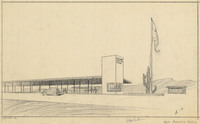
 The digitized architectural drawings and paintings presented are drawn from the Alfred Eichler Collection, within the Architecture Division of the Department of Public Works records housed at the California State Archives. Featured are public project designs created by Eichler from 1925 to 1962, such as San Quentin and Folsom Prisons, Sacramento’s Tower Bridge, state fairgrounds, Stockton and Napa state hospitals, School for the Deaf in Berkeley, state universities, Benicia State Capitol restoration, the Yountville Veterans Home, and others. Eichler utilized a variety of styles and art media to create these pieces. Each one is an example of the Golden State’s efforts to address the needs of a diverse and growing population through public projects.
-
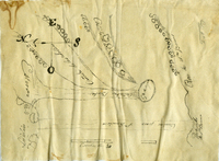 Diseños Collection
 Note: Certain images in this collection don’t display properly on iPhone. For best experience please use an Android phone or your desktop browser to view this site.
Within the Diseños Collection there are 493 hand-drawn sketch maps, or diseños, that were created from approximately 1866-1871. These sketch maps were hand-copied from originals created from approximately 1827-1846. These are part of a larger collection that makes up the Spanish and Mexican Land Grant Records that also include expedientes, or written documents regarding the grant petition.
At the end of the Mexican-American War in 1848, California became a territory of the United States after Mexico and the United States signed the Treaty of Guadalupe Hidalgo. Among other things, the treaty directed the U.S. government to honor legitimate land claims of Mexican citizens in the territory. Official copies of the provincial records kept in Monterey by the Spanish and Mexican governments were used by the new government to confirm land claims. Included in the title papers are sketch maps (diseños) and expedientes. The Mexican land grant process had a major influence on the development of California land by shaping settlement patterns and land ownership. As some of the earliest maps in California, diseños are essential to understanding the complex system of land ownership in the state today.About the Spanish and Mexican Land Grants Records
As U.S. government officials collected the provincial records, Congress passed the Land Act of 1851 creating the Board of Land Commissioners. The Board would review the records and resolve land claims in the newly acquired region. In addition, this act entrusted the U.S. Surveyor General with surveying confirmed land grants. Landowners had two years to present their claim to the board by providing their copy of the grant with the governor’s seal. Failure to present their claims within those two years would result in forfeiture of the land, which would become public land.
The Board of Land Commissioners operated for a total of five years. During this time, they operated mostly out of San Francisco but also operated out of Los Angeles for a brief time in 1852. Former Mexican citizens had to rely on translators and lawyers to help them through the submission process and later the appeal process in the federal courts, a process that on average took thirty years to complete. In general, petitioners had to wait seventeen years for the final patent for their land. The travel expenses coupled with legal fees led many to bankruptcy. Falling cattle prices and a few years of drought crippled many of the most prominent ranchos. As a result, most of the rancho lands were sold off at reduced prices to those who could afford the legal fees. During this period much of the land transferred to incoming American settlers. Others dealt with squatters taking their land from them. In the end, the Land Commissioners reviewed 813 grant claims, but only approved 553.
Diseños were used throughout the land grant process under the Spanish, Mexican and U.S. governments to show boundaries. These hand drawn maps mainly use naturally occurring boundaries such as rivers, mountains, rock outcropping, and trees as markers. Many of the diseños have labeled neighboring properties and as part of the initial land grant process all borders were agreed upon by surrounding landowners. The diseños also show existing travel routes, locations of houses and local place names. Using natural landmarks as markers would become problematic under the U.S. government, as changing landscapes made proving the borders difficult. For this reason, the U.S. Surveyor General conducted their own survey of the confirmed grant properties in an effort to settle boundaries.
Chapter 281, Statutes of 1865-1866, required the Secretary of State to engross all original grants and documents relating to the titles of land in the state derived from the Spanish or Mexican governments, along with accurate translations. The documents were housed at the Office of the United States Surveyor General in San Francisco, and Rufus C. Hopkins, Keeper of the Archives in that office, executed the work from 1866 to 1871. The diseños in the State Archives collection are copies of the original hand-drawn maps found in the individual expedientes. At the request of the legislature, the records from Monterey were transcribed and deposited at the State Archives in 1871. California's Evidence Code §1605, provides that the Spanish-Mexican land grant records in the State Archives are receivable as prima facie evidence with like force and effect as the originals.