-
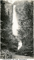
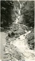 McCarthy Album 04, Photograph 170
 Caption: "Columbia River Scenes," c. 1920. Waterfall in upper part of photograph, with stream in foreground. A small footbridge can be seen at the base of the second tier of the falls.
-
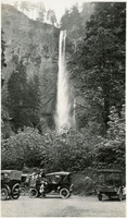
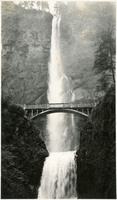 McCarthy Album 04, Photograph 169
 No caption, c. 1920. Waterfall with lush vegetation along the Columbia River in Oregon. The Benson Footbridge, built in 1914, is featured at the center of the photograph.
-
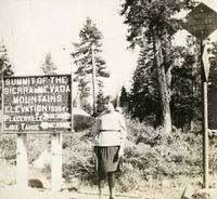 McCarthy Album 04, Photograph 168
 No caption, c. 1915-1920. Unidentified women standing at a summit point in the Sierra Nevada Mountains, at elevation 7,630 feet. She is standing next to a road sign with directions and distances to Placerville and Lake Tahoe listed.
-
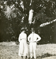 McCarthy Album 04, Photograph 167
 No caption, c. 1920-1925. William and Grace McCarthy standing in an unidentified location, in front of a tree.
-
 McCarthy Album 04, Photograph 166
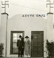
 Caption: "Santa Cruz," c. 1920-1925. William and Grace McCarthy posed in front of an unidentified, stuccoed building in Santa Cruz, California.
-
 McCarthy Album 04, Photograph 165
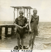
 Caption: "Lake Tahoe," c. 1915-1920. Two unidentified women, the same two appearing in 96-07-08-alb04-164, wearing swimsuits, on a beach at Lake Tahoe.
-
 McCarthy Album 04, Photograph 164
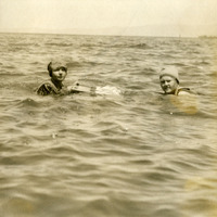
 No caption, c. 1915-1920. Two unidentified women swimming in what is likely Lake Tahoe
-
 McCarthy Album 04, Photograph 163
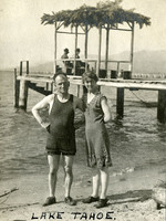
 Caption: "Lake Tahoe.," c. 1915-1920. William and Grace McCarthy in swimsuits on a beach at Lake Tahoe.
-
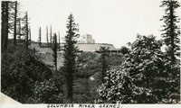 McCarthy Album 04, Photograph 162
 Caption: "Columbia River Scenes.," c. 1920. Shows the Vista House and Crown Point from a point on the hillside below. The Vista House was built in 1918 as a memorial to Oregon's pioneers. Designed by Edgar M. Lazarus, it sits atop Crown Point, a rocky promontory overlooking the Columbia River gorge, along the Historic Columbia River Highway.
-
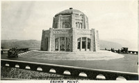 McCarthy Album 04, Photograph 161
 Caption: "Crown Point.," c. 1920. Shows the Vista House, built in 1918 as a memorial to Oregon's pioneers. Designed by Edgar M. Lazarus, it sits atop Crown Point, a rocky promontory overlooking the Columbia River gorge, along the Historic Columbia River Highway.
-
 McCarthy Album 04, Photograph 160
 Caption: "Columbia River Scenes," c. 1920. Waterfall with lush vegetation along the Columbia River in Oregon. The Benson Footbridge, built in 1914, can be seen through the trees near the base of the waterfall.
-
 McCarthy Album 04, Photograph 159
 No caption, c. 1920. Waterfall with lush vegetation along the Columbia River in Oregon.
-
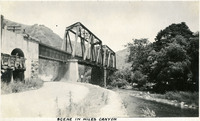 McCarthy Album 04, Photograph 158
 Caption: "Scene in Niles Canyon," c. 1915-1920. Shows a railroad trestle over a creek in Niles Canyon, in Alameda County (the San Francisco Bay Area).
-
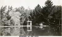 McCarthy Album 04, Photograph 157
 Caption: "Portals of the Past," c. 1915-1920. A monument in Golden Gate Park in San Francisco, on the shores of Lloyd Lake, consisting of a white marble archway and columns. The archway was originally part of the Nob Hill mansion belonging to railroad tycoon Alban Towne. The mansion was destroyed in the 1906 San Francisco earthquake and fire, but the entryway still stood. It was moved to the shore of Lloyd Lake in 1909, as a memorial to the pre-1906 city.
-
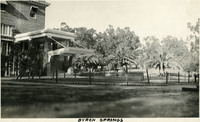 McCarthy Album 04, Photograph 156
 Caption: "Byron Springs," c. 1915-1920. Grounds and entrance to the Byron Hot Springs resort hotel, built in 1913 (the third hotel on the site).
-
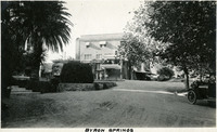 McCarthy Album 04, Photograph 155
 Caption: "Byron Springs," c. 1915-1920. Byron Hot Springs resort hotel, built in 1913 (the third hotel on the site).
-
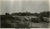 McCarthy Album 04, Photograph 154
 Caption: "Folsom Highway Bridge," c. 1915-1920. Bridge over unidentified creek in the vicinity of Folsom.
-
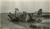 McCarthy Album 04, Photograph 153
 Caption: "Gold Dredging near Folsom, Calif.," c. 1915-1920. Gold dredger in the American River.
-
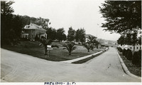 McCarthy Album 04, Photograph 152
 Caption: "Presidio -- S.F.," c. 1915-1920. Crossroads in the Presidio, with manicured grounds and buildings on all sides.
-
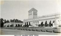 McCarthy Album 04, Photograph 151
 Caption: "Museum -- Golden Gate Park," c. 1922. The Memorial Museum in Golden Gate Park, designed by Louis Christian Mulgardt in the Spanish-Plateresque style, was built in 1919. Michael H. de Young, co-founder of the San Francisco Chronicle, added the central tower in 1921. The museum's name was later changed to honor de Young, becoming the M. H. de Young Memorial Museum (now commonly known as the de Young Museum). This building has since been replaced with a more modern facility.
-
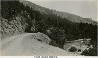 McCarthy Album 04, Photograph 150
 Caption: "Yuba River Scene.," c. 1920. Mountain scene with graveled road at left and river at right.
-
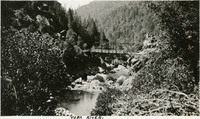 McCarthy Album 04, Photograph 149
 Caption: "Yuba River.," c. 1920. River scene with bridge in center of photograph.
-
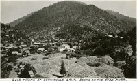 McCarthy Album 04, Photograph 148
 Caption: "Gold Mining at Downieville, Calif. Scene on the Yuba River," c. 1920. Small town nestled at foot of mountain, with gravel piles in foreground. Downieville was settled in 1849 during the California Gold Rush.
-
 McCarthy Album 04, Photograph 147
 Caption: "On the Banks of the Yuba River.," c. 1920. Grace McCarthy standing with automobile on graveled country road, with the Yuba River visible on the right side of the photograph.
-
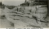 McCarthy Album 04, Photograph 146
 Caption: "An Abandoned Hydraulic Mine near Camptonville Calif.," c. 1920. Hillside ravaged by hydraulic mining, in which a pressurized jet of water washes sediment and gravel into a series of sluices, allowing the heavier gold and gold-carrying sediment to sink to the bottom for removal. California banned this environmentally destructive practice in 1884.
-
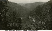 McCarthy Album 04, Photograph 145
 Caption: "The Mountain Highway Near Camptonville," c. 1920. Mountain scene, likely in or near Yuba County, California.
-
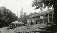
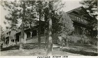 McCarthy Album 04, Photograph 144
 Caption: "Feather River Inn," c. 1920. Built in 1915 near Blairsden. The property was sold in 1970, becoming the Feather River Preparatory School, before being purchased in 1977 by the University of the Pacific.
-
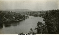 McCarthy Album 04, Photograph 143
 Caption: "Feather River -- Calif.," c. 1920. Bend in the Feather River, a tributary of the Sacramento River.
-
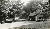 McCarthy Album 04, Photograph 142
 Caption: "Toll Gate -- St Helena Mountain.," c. 1920. Toll gate consists of a long wooden spar across the road, with a small building to the right. Grace McCarthy is standing next to an automobile at the gate. The St. Helena Toll Road, now part of California State Route 29, connected the Napa Valley with Lake County. It was built in 1868, and purchased by the State of California in 1925.
-
 McCarthy Album 04, Photograph 141
 Caption: "Harbin Springs -- Lake Co," c. 1920. Resort buildings at Harbin Springs, home of the Harbin Hot Springs.
-
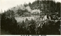 McCarthy Album 04, Photograph 140
 Caption: "W.P.R.R. Feather River," c. 1920. Western Pacific Railroad train making its way along the Feather River in California.
-
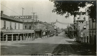 McCarthy Album 04, Photograph 139
 Caption: "Marysville -- Calif.," c. 1920. Main Street of Marysville, California.
-
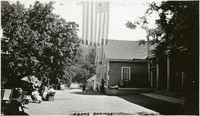
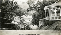 McCarthy Album 04, Photograph 138
 Caption: "Adams Springs -- Lake Co.," c. 1920. Buildings in Adams Springs, likely part of the resort that operated there in the first half of the twentieth century.
-
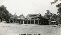 McCarthy Album 04, Photograph 137
 Caption: "Seiglers Springs -- Lake Co.," c. 1920. Resort building at Seigler Springs.
-
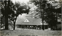 McCarthy Album 04, Photograph 136
 Caption: "Hobergs Resort -- Lake Co.," c. 1920. Resort buildings nestled in grove of trees. Built in 1885, the resort stood until 2015, when it was destroyed by the Valley Fire.
-
 McCarthy Album 04, Photograph 135
 Caption: "Adams Springs.," c. 1920. Buildings in Adams Springs, likely part of the resort that operated there in the first half of the twentieth century.
-
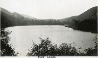 McCarthy Album 04, Photograph 134
 Caption: "Blue Lakes," c. 1920. Lake with rolling hills/mountains in the distance.
-
 McCarthy Album 04, Photograph 133
 Caption: "Blue Lakes Resort -- Lake County," c. 1920. Lake with resort buildings in center of photograph, mountains in the background.
-
 McCarthy Album 04, Photograph 132
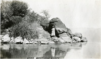
 Caption: "Soda Bay -- Lake County," c. 1920. Grace McCarthy on the shores of Soda Bay, at Clear Lake.
-
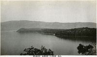 McCarthy Album 04, Photograph 131
 Caption: "Clear Lake -- Lake Co.," c. 1920. Lake surrounded by mountains.
-
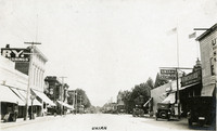 McCarthy Album 04, Photograph 130
 Caption: "Ukiah," c. 1920. Street scene in Ukiah, with Ukiah Stables and The Richelieu at right.
-
 McCarthy Album 04, Photograph 129
 Caption: "McCrays," c. 1920. Building with "McCray's" sign over porch, likely in Lake County, California.
-
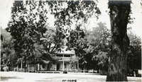
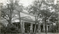 McCarthy Album 04, Photograph 128
 Caption: "Highland Springs," c. 1920. Highland Springs resort building in Lake County.
-
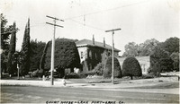 McCarthy Album 04, Photograph 127
 Caption: "Court House -- Lake Port -- Lake Co.," c. 1920. Shows the second of three courthouses that have served Lake County, in Lakeport, California. The building in this image, constructed in 1871, served as the county courthouse until it was replaced in 1968.
-
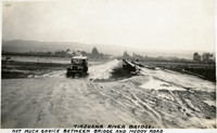 McCarthy Album 04, Photograph 126
 Caption: "Tiajuana [sic] River Bridge. Not much choice between bridge and muddy road," c. 1915-1916. Dilapidated bridge on right side of photograph, with automobile driving over muddy road next to the bridge.
-
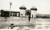 McCarthy Album 04, Photograph 125
 Caption: "Casino -- Tiajuana [sic]," c. 1915-1916. Wet, rainy scene showing a building dominated by two large towers at the entrance.
-
 McCarthy Album 04, Photograph 124
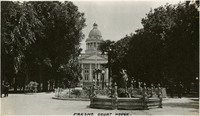
 Caption: "Fresno Court House.," c. 1920. Shows the historic Fresno County Courthouse, built in 1875, as well as a small fountain. This courthouse was torn down in 1966 to make way for a more modern facility.
-
 McCarthy Album 04, Photograph 123
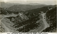
 Caption: "Bakersfield-Los Angeles Ridge Route. Note the winding road. (X) marks the road in the distance." c. 1920. Mountain scene showing road winding around hills and ridges, with a few scattered automobiles also present. First opened in 1915, the Ridge Route was the first paved highway connecting Los Angeles with the San Joaquin Valley.
-
 McCarthy Album 04, Photograph 122
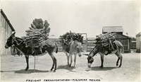
 Caption: "Freight Transportation -- Tiajuana [sic], Mexico," c. 1915-1916. Three donkeys loaded with packs of what appear to be firewood.
-
 McCarthy Album 04, Photograph 121
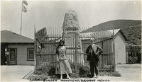
 Caption: "Border Monument, Tiajuana [sic] Mexico." William and Grace McCarthy standing in front of the monument placed at the U.S.-Mexico border in Tijuana, Mexico.