-
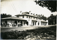
 McCarthy Album 02, Photograph 072
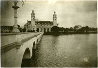
 No Caption: See also 96-07-08-alb08-158 with caption: "Government Building and Bridge of Nations, Portland Fair," Portland, Oregon, 1905. Shows the Government Building, Guild's Lake, and the Bridge of Nations, a long pedestrian bridge over the lake. Some of the more than 100,000 light bulbs used to outline the exposition's buildings can be seen along the arches and decorative molding of the bridge. The Lewis and Clark Centennial Exposition was held in Portland, Oregon from June 1st to October 15th, 1905. It celebrated the one-hundred year anniversary of the exploratory expedition of the Louisiana Purchase and what became the northwestern part of the United States, led by Meriwether Lewis and William Clark. Some 1.6 million people visited the fair, viewing exhibits from twenty-one countries.
-
 McCarthy Album 02, Photograph 071
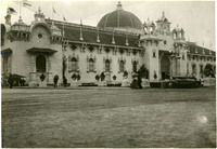
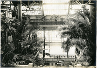
 No Caption: See also 96-07-08-alb08-156 with caption: "Agricultural Building, Portland Fair, 1905." View of the Agriculture and Horticulture Building at the Lewis and Clark Centennial Exposition. The exposition was held in Portland, Oregon from June 1st to October 15th, 1905. It celebrated the one-hundred year anniversary of the exploratory expedition of the Louisiana Purchase and what became the northwestern part of the United States, led by Meriwether Lewis and William Clark. Some 1.6 million people visited the fair, viewing exhibits from twenty-one countries.
-
 McCarthy Album 02, Photograph 070
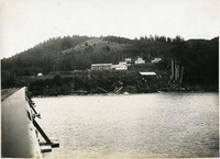
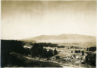
 No Caption: See also 96-07-08-alb08-140 with caption: "Fort Columbia, Wash." c. 1910. Fort Columbia, built between 1896 and 1904, sits on Chinook Point overlooking the Columbia River. It is part of the Three Fort Harbor Defense System protecting the mouth of the river from enemy incursion or attack (the other forts being Oregon's Fort Stevens and Washington's Fort Canby). Fort Columbia was decomissioned after World War II, and is now the site of a Washington State Park.
-
 McCarthy Album 02, Photograph 069
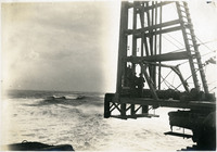
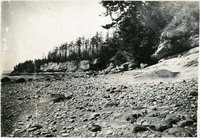
 No Caption: See also 96-07-08-alb08-145 with caption: "Pile Driver in the Breakers, Columbia River Jetty," c. 1910. View of a large pile driver used in the construction of the jetty system at the mouth of the Columbia River. This is likely at the end of the so-called South Jetty, extending more than six miles into the ocean from Point Adams on the Oregon side of the river mouth. The jetty system at the mouth of the Columbia River was constructed between 1885 and 1917. Designed to funnel water from the Columbia River in a more concentrated fashion into the Pacific Ocean, the jetty system helped create a deeper, more stable shipping channel.
-
 McCarthy Album 02, Photograph 068
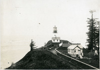
 No Caption: See also 96-07-08-alb08-153 with caption: "Fort Canby Light House, Wash." c. 1910. View of the Cape Disappointment Lighthouse on a rocky point overlooking the mouth of the Columbia River. Cannons and cannon balls are stored on the lighthouse property. Built in the 1850s, the lighthouse was electrified in 1934 and automated in 1973. The lighthouse is now part of the Cape Disappointment State Park (formerly Fort Canby State Park).
-
 McCarthy Album 02, Photograph 067
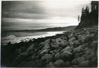
 No Caption: See also 96-07-08-alb08-147 with caption: "Seaside Beach, Or." c. 1908.
-
 McCarthy Album 02, Photograph 066
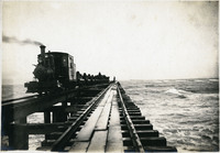
 No Caption: See also 97-07-08-alb08-143 with caption: "Columbia River Jetty, Or.," c. 1910. View of a jetty built at the mouth of the Columbia River, carrying a railroad trestle. A train hauling cars loaded with large rocks is visible at the left side of the photograph. This is likely the so-called South Jetty, extending more than six miles into the ocean from Point Adams on the Oregon side of the river mouth. The jetty system at the mouth of the Columbia River was constructed between 1885 and 1917. Designed to funnel water from the Columbia River in a more concentrated fashion into the Pacific Ocean, the jetty system helped create a deeper, more stable shipping channel.
-
 McCarthy Album 02, Photograph 065
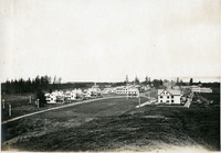
 No Caption: See also 96-07-08-alb08-139 with caption: "Fort Stevens, Or," c. 1910. A view of buildings at Fort Stevens, part of the Three Fort Harbor Defense System protecting the mouth of the Columbia River from enemy incursion or attack (the other forts being Fort Columbia and Fort Canby, both in Washington). Built during the Civil War, the fort remained active until after World War II. In June 1942, Fort Stevens gained the dubious distinction of being the only military installation in the continental United States to come under enemy fire when a Japanese submarine surfaced off the coast and fired seventeen missiles at the fort. The missiles destroyed the backstop to the fort's baseball field, but otherwise did little harm. Fort Stevens was decommissioned in 1947. It was later turned over to the Oregon Parks and Recreation Department, and currently is the site of an Oregon State Park.
-
 McCarthy Album 02, Photograph 064
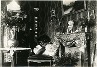
 No Caption: See also 96-07-08-alb08-053 with caption: "Port Townsend Parlor Scene," Washington, c. 1908.
-
 McCarthy Album 02, Photograph 063
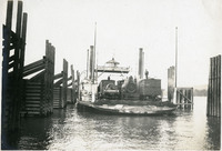
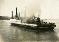
 No Caption: See also 96-07-08-alb08-114 with caption: "Ferry Boat Tacoma on the Columbia River," Pacific Northwest, c. 1905. View of the railroad ferry Tacoma, with a train on board. The Tacoma operated from 1884 until 1908, when a railroad bridge was constructed across the Columbia River, connecting Portland, Oregon, with points north of the river.
-
 McCarthy Album 02, Photograph 062
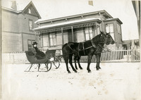
 No Caption: See also 96-07-08-alb08-051 with caption: "Sleighing - Port Townsend." William and Grace McCarthy are seen sitting in a sleigh drawn by two horses at Port Townsend, Washington, c. 1908.
-
 McCarthy Album 02, Photograph 061
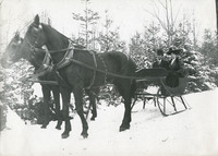
 No Caption: See also 96-07-08-alb08-049 with caption: "Sleighing - Port Townsend." Grace McCarthy is seen sitting in a sleigh drawn by two horses at Port Townsend, Washington, c. 1908.
-
 McCarthy Album 02, Photograph 060
 No Caption: See also 96-07-08-alb08-045 with caption: "Fort Flagler Beach," c. 1908.
-
 McCarthy Album 02, Photograph 059
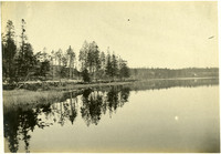
 No Caption: See also 96-07-08-alb08-021 with caption: "Fort Casey Lake, Reflections." Landscape at Crockett Lake, near Fort Casey, c. 1908.
-
 McCarthy Album 02, Photograph 058
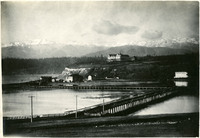
 No Caption: See also 96-07-08-alb08-082 with caption: "The Olympic Snow-capped Mountains," Washington, c. 1908. Vista of the Olympic Mountains in the distance. In the middle distance to the right can be seen the Eisenbeis Castle (now known as the Manresa Castle Restaurant and Lounge), built in 1892 by Charles Eisenbeis, a businessman and Port Townsend's first mayor. The photograph is centered around what appears to be a resort hotel situated a short distance from the Eisenbeis Castle.
-
 McCarthy Album 02, Photograph 057
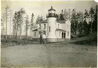
 No Caption: See also 96-07-08-alb03-065 with caption: "Fort Casey Lighthouse, Washington," c. 1910. Fort Casey was part of the "triangle of fire," three coastal defense fortifications (Fort Casey, Fort Worden, and Fort Flagler) guarding the entrance to Puget Sound. Construction began on the fort in 1897, and the U.S. Army used the facility until the 1950s, when the fort was decommissioned. The area is now a state park.
-
 McCarthy Album 02, Photograph 056
 No Caption: See also 96-07-08-alb08-024 with caption: Ordnance Avenue, Fort Casey," Washington, c. 1908. Fort Casey was part of the "triangle of fire," three coastal defense fortifications (Fort Casey, Fort Worden, and Fort Flagler) guarding the entrance to Puget Sound. Construction began on the fort in 1897, and the U.S. Army used the facility until the 1950s, when the fort was decommissioned. The area is now a state park.
-
 McCarthy Album 02, Photograph 055
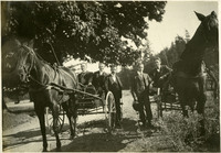
 No Caption: See also 96-07-08-alb08-066 with caption: "In Victoria, B.C." Five men (William McCarthy in the center) sitting in and standing near horse-drawn buggies in Victoria, British Columbia, c. 1906.
-
 McCarthy Album 02, Photograph 054
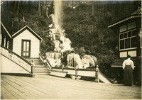
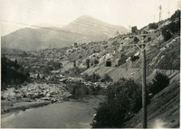
 No Caption: See also 96-07-08-alb03-070 with caption: "Shasta Springs." Waterfall, hillside, and buildings at Shasta Springs, c. 1910. Shasta Springs, just north of Dunsmuir, California, in the Trinity Mountains, was a resort area in the late nineteenth and early twentieth centuries. It centered around natural springs, which became a featured stop on the Southern Pacific Railroad's Shasta Route. The resort operated until the 1950s, when it was purchased by private interests.
-
 McCarthy Album 02, Photograph 053
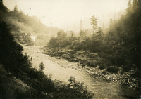
 No Caption: See also 96-07-08-alb08-169 with caption:"On the Shasta Route, Cal," c. 1910. Photograph likely taken from an observation car, showing a train running along a creek or river in a mountainous area. Given the caption, this is likely in the Siskiyou Mountains, Trinity Mountains, or the Cascade Range, but the specific location is unidentified.
-
 McCarthy Album 02, Photograph 052
 No Caption: See also 96-07-08-alb06-115 with caption: "On the Sacramento River," unidentified location, c. 1906.
-
 McCarthy Album 02, Photograph 051
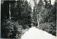
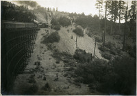
 No Caption: See also 96-07-08-alb08-155 with caption: "Trestle in Oregon, Taken from Observation Car Platform," c. 1906.
-
 McCarthy Album 02, Photograph 050
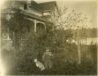
 No Caption: See also 96-07-08-alb06-078 with caption: "Harrold and Buff," c. 1906. A young child with a dog is seen standing near a fence at the McCarthy home in Watsonville.
-
 McCarthy Album 02, Photograph 049
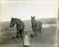
 No Caption: See also 96-07-08-alb06-080 with caption: "Young Hostler, Harrold," c. 1906. Shows a young child with two horses on the McCarthy property in Watsonville.
-
 McCarthy Album 02, Photograph 047
 No Caption: See also 96-07-08-alb06-193, with caption: "Fillmore St. Dec. 10, 1906." A view of a flooded Fillmore Street in San Francisco during the winter of 1906.
-
 McCarthy Album 02, Photograph 046
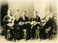
 No Caption: See also 96-07-08-alb06-108, with caption: "Crockett Mandolin Club," c. 1906. William McCarthy is seen strumming the mandolin, second from left.
-
 McCarthy Album 02, Photograph 045
 No Caption: A front page Seattle Daily Times article and photographs reporting on the April 18, 1906 San Francisco earthquake, with the headline: "City Wiped Out! Fire Still Raging!" April 20, 1906.
-
 McCarthy Album 02, Photograph 044
 No Caption: A view of the ferryboat, Solano, in Contra Costa County, California, c. 1906.
-
 McCarthy Album 02, Photograph 043
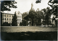
 No Caption: c. 1906. The Stockton Insane Asylum was established in 1851, completed in 1853, and was the first public mental health hospital in California. It remained a functioning state hospital until 1995.
-
 McCarthy Album 02, Photograph 042
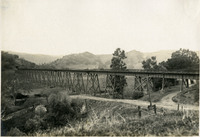
 No Caption: Santa Fe Railroad Trestle, Martinez, California, c. 1906.
-
 McCarthy Album 02, Photograph 041
 No Caption: Santa Fe Depot, Stockton, California, c. 1906. The Santa Fe Depot (William Benson Storey, architect) was completed in 1899 for the Atchison, Topeka, and Santa Fe Railway. Added to the National Register of Historic Places in 1976, the depot was renovated and restored it to its original design and reopened in 2005.
-
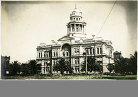 McCarthy Album 02, Photograph 040
 No Caption: San Joaquin County Courthouse (E.E. Myers, architect), Stockton, California, c. 1906. The neoclassical building was completed in 1890 and demolished in 1961 to make way for a new courthouse.
-
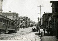 McCarthy Album 02, Photograph 039
 No Caption: See also 96-07-08-alb06-203 with caption: "Fillmore, the new Market Street," c. 1907. A view of a busy Fillmore Street indicating that much of the city's business has moved from Market Street during reconstruction after the earthquake.
-
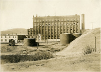 McCarthy Album 02, Photograph 038
 No Caption: The Californian and Hawaiian Sugar Refining Company Building in Crockett, Contra Costa County, California, c. 1906.
-
 McCarthy Album 02, Photograph 037
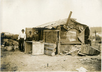
 No Caption: See also 96-07-08-alb05-018 with caption: "Italian Refugee Hut S.F. 1906." Makeshift hut with four unidentified men standing in doorway. After the earthquake and fire that destroyed much of San Francisco in April 1906, hundreds of thousands of people were left homeless. Many of these people established temporary refugee camps, using debris from the destruction to cobble together shelters.
-
 McCarthy Album 02, Photograph 036
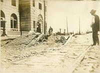
 No Caption: See also 96-07-08-alb06-168 with caption: "Mission Street After the Quake." A view of Mission Street damage resulting from the San Francisco earthquake.
-
 McCarthy Album 02, Photograph 035
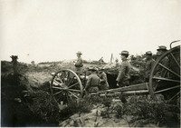
 No Caption: See also 96-07-08-alb06-227, with caption: "Field Piece in Action." Unidentified location, c. 1905.
-
 McCarthy Album 02, Photograph 034
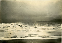
 No Caption: See also 96-07-08-alb03-097 with caption: "Wave on Bakers Beach Presidio," San Francisco, California, c. 1906.
-
 McCarthy Album 02, Photograph 033
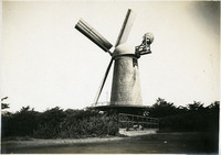
 No Caption: The Dutch Windmill at the western edge of Golden Gate Park, San Francisco, c. 1906.
-
 McCarthy Album 02, Photograph 032
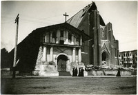
 No Caption: Mission Delores, the oldest intact building still standing in San Francisco today, suffered little damage from the 1906 earthquake. The parish church next to it was greatly damaged and rebuilt as the Mission Dolores Basilica, opened in 1918.
-
 McCarthy Album 02, Photograph 031
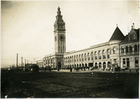
 No Caption: A view of the Ferry Building, located at the end of Market Street along the San Francisco Embarcadero, which survived the 1906 earthquake and fires with little damage.
-
 McCarthy Album 02, Photograph 030
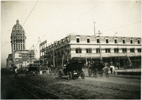
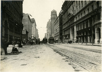
 No Caption: A view of the reconstruction on Market Street after the 1906 earthquake and fires, c. 1907.
-
 McCarthy Album 02, Photograph 029
 No Caption: A view of the reconstruction on Market Street after the 1906 earthquake and fires, c. 1907.
-
 McCarthy Album 02, Photograph 028
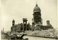
 No Caption: The San Francisco City Hall in ruins after the 1906 earthquake and resulting fires.
-
 McCarthy Album 02, Photograph 027
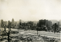
 No Caption: A view of San Francisco in ruins after the 1906 earthquake and fires devastated the city.
-
 McCarthy Album 02, Photograph 026
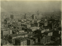
 No Caption: See also 96-07-08-alb08-182, with caption: "San Francsico April 17, 1906. Center of Town." Bird's eye view of the center of San Francisco before the 1906 earthquake and fire. The Call Building (built in the 1890s to house the San Francisco Call newspaper) is the tallest building in the photograph, just to the right of center.
-
 McCarthy Album 02, Photograph 025
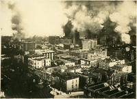
 No Caption: See also 96-07-08-alb08-183, with caption: "San Francisco April 18, 1906. Center of Town. The Awful Fire after the Shake." Fire engulfing buildings in San Francisco's city center after the 1906 earthquake. Great plumes of smoke dominate the photograph.
-
 McCarthy Album 02, Photograph 024
 No Caption: A bird's eye view of the Presidio at San Francisco, California, c. 1906. See also 96-07-08-alb08-178.
-
 McCarthy Album 02, Photograph 023
 No Caption: Interior shot of the Sutro Baths, north of the Cliff House, c. 1910. Designed by Adolph Sutro in 1894, the bathhouses at one time covered three oceanfront acres just north of Ocean Beach and the Cliff House. Eventually, the Sutro Baths fell into disrepair and what was left of them burned down in 1966. Since 1973, the concrete ruins have been part of the Golden Gate National Recreation Area.
-
 McCarthy Album 02, Photograph 022
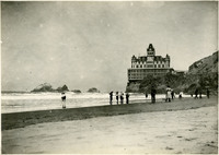
 No Caption: The Cliff House, overlooking bathers at Ocean Beach, San Francisco, California, c. 1905. Unidentified people enjoying the surf and beach at Ocean Beach, overlooked by the iconic San Francisco Cliff House. The Victorian structure shown here is the third iteration of the Cliff House, constructed in 1896. It was later destroyed by a fire, in 1907.