-
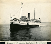 McCarthy Album 08, Photograph 063
 Caption: "Steamer, Princess Beatrice, Seattle.," c. 1908-1912. View of the Princess Beatrice, a steamship operated by the Canadian Pacific Railway (CPR) between Seattle, Washington, and Victoria, British Columbia. Built in 1903, she made her first trip in January 1904. The CPR operated several ships in the Pacific Northwest, all of which were christened with "Princess" in the name. As a result, the CPR naval fleet was often referred to as "The Pacific Princesses" or the "Princess Fleet."
-
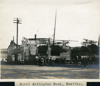 McCarthy Album 08, Photograph 062
 Caption: "Burnt Arlington Dock, Seattle." This photograph shows the result of a fire at Seattle's Arlington Dock on May 7, 1906. Heavy fire damage can be seen on the building pictured. Its roof and the central portion of the façade collapsed, and burn marks appear at all windows. Thousands of dollars' worth of supplies were destroyed in the fire. At the time, Arlington Dock was the primary shipping facility for the city.
-
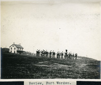 McCarthy Album 08, Photograph 061
 Caption: "Review, Fort Worden.," c. 1908-1912. Shows a military band playing or preparing to play, with rows of troops assembled in the background on the right side of the photograph. Fort Worden is located in Port Townsend, Washington, on Admiralty Inlet of Puget Sound. Construction began on the fort in 1898, and by 1902 it was serving as an active U.S. Army base. Fort Worden was part of the "triangle of fire," three coastal defense fortifications (Fort Casey, Fort Worden, and Fort Flagler) guarding the entrance to Puget Sound. The U.S. sold the property to the State of Washington in 1957. In 1973, the fort and surrounding area opened as Fort Worden State Park.
-
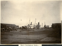 McCarthy Album 08, Photograph 060
 Caption: "Port Townsend Dock," c. 1908-1912. View of wharf facilities at Port Townsend, including several ships (one of which may be a ferry) and miscellaneous outbuildings.
-
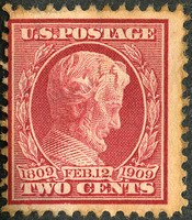 McCarthy Album 08, Photograph 059a
 No Caption: U.S. two-cent postage stamp issued in 1909 featuring Abraham Lincoln's profile. The stamp marked the centennial of Lincoln's birth on February 12, 1809.
-
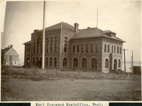 McCarthy Album 08, Photograph 059
 Caption: "Port Townsend Postoffice [sic], Wash.," c. 1908-1912. View from the rear of the Port Townsend U.S. Customs Office and Post Office. The oldest federally-constructed post office in the state of Washington, the Richardson Romanesque-style building was completed in 1893.
-
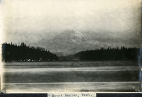 McCarthy Album 08, Photograph 058
 Caption: "Mount Ranier [sic], Wash.," c. 1908-1912. View of Mount Rainier, the highest peak in the Cascade Range and in the state of Washington, and part of the eastern rim of the Pacific Ring of Fire. Although it is now dormant, it is considered to be a high-risk volcano.
-
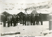 McCarthy Album 08, Photograph 057
 Caption: "Snow Scene -- Port Townsend.," c. 1908-1912. Group of unidentified men standing in two groups in the snow.
-
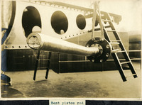 McCarthy Album 08, Photograph 056
 Caption: "Bent piston rod," c. 1908-1912. View of a damaged piston rod, that appears to be part of a disappearing carriage for a heavy artillery gun, most likely at Fort Flagler.
-
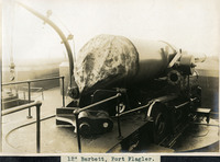 McCarthy Album 08, Photograph 055
 Caption: "12" Barbett [sic], Fort Flagler.," c. 1908-1912. View of a 12" disappearing gun at Fort Flagler. The coastal artillery fortification Fort Flagler was established in 1897 and activated in 1899. Most of the fort's buildings and batteries had been completed by 1907. Fort Flagler was part of the "triangle of fire," three coastal defense fortifications (Fort Casey, Fort Worden, and Fort Flagler) guarding the entrance to Puget Sound. Fort Flagler was decommissioned in 1953, and purchased by the State of Washington in 1955 for use as a state park.
-
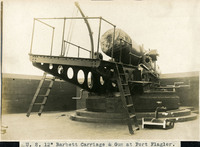 McCarthy Album 08, Photograph 054
 Caption: "U. S. 12" Barbett [sic] Carriage & Gun at Fort Flagler.," c. 1908-1912. View of a 12" disappearing gun installed at Fort Flagler. The coastal artillery fortification Fort Flagler was established in 1897 and activated in 1899. Most of the fort's buildings and batteries had been completed by 1907. Fort Flagler was part of the "triangle of fire," three coastal defense fortifications (Fort Casey, Fort Worden, and Fort Flagler) guarding the entrance to Puget Sound. Fort Flagler was decommissioned in 1953, and purchased by the State of Washington in 1955 for use as a state park.
-
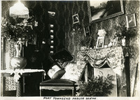 McCarthy Album 08, Photograph 053
 Caption: "Port Townsend Parlor Scene.," c. 1908-1912. View of a parlor in a Port Townsend residence.
-
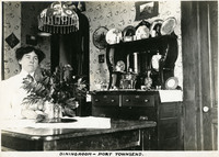 McCarthy Album 08, Photograph 052
 Caption: "Diningroom [sic] -- Port Townsend.," c. 1908-1912. Grace McCarthy seated at a desk in a parlor or dining room of a residence in Port Townsend.
-
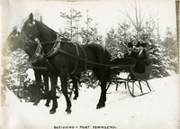 McCarthy Album 08, Photograph 051
 Caption: "Sleighing -- Port Townsend.," c. 1908-1912. William and Grace McCarthy sitting in a sleigh pulled by two horses, in a snowy landscape.
-
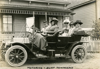 McCarthy Album 08, Photograph 050
 Caption: "Motoring -- Port Townsend," c. 1908-1912. Grace McCarthy (farthest to the right in backseat) and group of unidentified friends and/or family posing in an automobile in front of a Port Townsend residence.
-
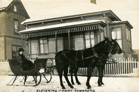 McCarthy Album 08, Photograph 049
 Caption: "Sleighing -- Port Townsend," c. 1910. Grace McCarthy sitting in horse-drawn sleigh in front of a snow-covered residence in Port Townsend, Washington. See also 96-07-08-alb05-114.
-
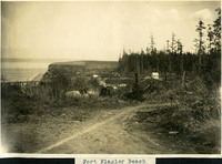 McCarthy Album 08, Photograph 048
 Caption: "Fort Flagler Beach," c. 1908-1912. This photograph features a dirt track in the foreground, with various buildings in the middle distance and a headlands and body of water, possibly Puget Sound, in the far distance.
-
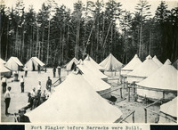 McCarthy Album 08, Photograph 047
 Caption: "Fort Flagler before Barracks were Built.," c. 1899-1906. The coastal artillery fortification Fort Flagler was established in 1897 and activated in 1899. Most of the fort's buildings and batteries had been completed by 1907. Fort Flagler was part of the "triangle of fire," three coastal defense fortifications (Fort Casey, Fort Worden, and Fort Flagler) guarding the entrance to Puget Sound. Fort Flagler was decommissioned in 1953, and purchased by the State of Washington in 1955 for use as a state park.
-
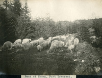 McCarthy Album 08, Photograph 046
 Caption: "Band of Sheep, Port Townsend.," c. 1908-1912. This photograph shows a herd of sheep grazing in a wooded area near Port Townsend, Washington.
-
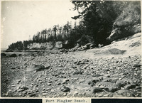 McCarthy Album 08, Photograph 045
 Caption: "Fort Flagler Beach.," c. 1908-1912. Shows a rocky beach with a small cliff in the distance.
-
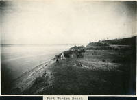
 McCarthy Album 08, Photograph 044
 Caption: "Port Townsend Beach.," c. 1908-1912. Tree on edge of cliff, with beach in the distance.
-
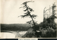
 McCarthy Album 08, Photograph 043
 Caption: "Fort Worden Beach.," c. 1908-1912. Ocean shore scene at Fort Worden, near Port Townsend. Construction began on the fort in 1898, and by 1902 it was serving as an active U.S. Army base. Fort Worden was part of the "triangle of fire," three coastal defense fortifications (Fort Casey, Fort Worden, and Fort Flagler) guarding the entrance to Puget Sound. The U.S. sold the property to the state of Washington in 1957. In 1973, the fort and surrounding area opened as Fort Worden State Park.
-
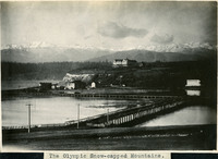 McCarthy Album 08, Photograph 042
 Caption: "The Olympic Snow-capped Mountains.," c. 1908-1912. View of a coastal inlet or tideland with raised roads, a large building (probably a resort hotel) in the middle distance, and the white-capped Olympic Mountains in the far distance.
-
 McCarthy Album 08, Photograph 041
 No Caption: c. 1910. Unidentified young girl posing with chicken, likely somewhere in Washington.
-
 McCarthy Album 08, Photograph 040
 No Caption: c. 1910. Woman posing with young girl, both of whom are unidentified, likely somewhere in Washington.
-
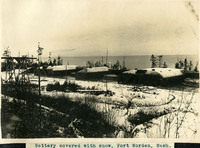 McCarthy Album 08, Photograph 039
 Caption: "Battery covered with snow, Fort Worden, Wash.," c. 1908-1912. Shows the three batteries at Fort Worden covered in a blanket of snow, with the ocean or Puget Sound in the distance. Construction began on the fort in 1898, and by 1902 it was serving as an active U.S. Army base. Fort Worden was part of the "triangle of fire," three coastal defense fortifications (Fort Casey, Fort Worden, and Fort Flagler) guarding the entrance to Puget Sound. The U.S. sold the property to the state of Washington in 1957. In 1973, the fort and surrounding area opened as Fort Worden State Park.
-
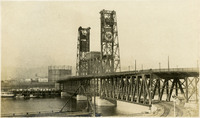 McCarthy Album 08, Photograph 038
 Caption: "Union Pacific Bridge -- Portland, OR.," c. 1915. Built in 1912, this through-truss, double-decker vertical lift bridge crosses the Willamette River in Portland, Oregon. See also 96-07-08-alb05-182.
-
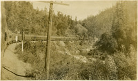 McCarthy Album 08, Photograph 037
 Caption: "Sacramento River Scene," c. 1910. Train running along Sacramento River in foothills or mountains. See also 96-07-08-alb08-037.
-
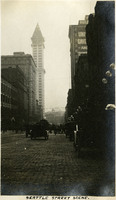 McCarthy Album 08, Photograph 036
 Caption: "Seattle Street Scene." Street view in Seattle, with Smith Tower in background. See also 96-07-08-alb05-178.
-
 McCarthy Album 08, Photograph 035
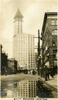
 Caption: "Smith Building -- Seattle." View of the neoclassical Smith Tower in Seattle, built by industrialist Lyman Cornelius Smith. At the time of its completion in 1914, the Smith Tower was the tallest building on the West Coast, until being superseded by the Space Needle in 1962. See also 96-07-08-alb05-177.
-
 McCarthy Album 08, Photograph 034
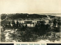
 Caption: "Snow scenery, Fort Worden, Wash.," c. 1908. Overview of Fort Worden in Port Townsend, Washington, on Admiralty Inlet of Puget Sound. Construction began on the fort in 1898. By 1902 it was serving as an active U.S. Army base. Fort Worden was part of the so-called "triangle of fire," three coastal defense fortifications (Fort Casey, Fort Worden, and Fort Flagler) guarding the entrance to Puget Sound. The U.S. sold the property to the State of Washington in 1957. In 1973, the fort and surrounding area opened as Fort Worden State Park.
-
 McCarthy Album 08, Photograph 033
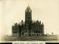
 Caption: "Court House, Port Townsend, Wash.," c. 1908-1912. View of the Jefferson County Courthouse in Port Townsend, Washington. Built the early 1890s and designed by W. A. Ritchie, the Romanesque-style building features a 124-foot clock tower, red bricks from St. Louis, and sandstone from Alaska.
-
 McCarthy Album 08, Photograph 032
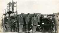
 No Caption: c. 1908-1912. Group of men posing around a 12-inch disappearing gun. Retracting or disappearing guns were a form of artillery developed in the nineteenth century in which heavy artillery guns were placed on rotating carriages that allowed retraction of the weapon after firing, to enable reloading while under enemy fire. Such guns were often used in coastal fortifications.
-
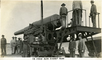 McCarthy Album 08, Photograph 031
 Caption: "12 Inch Sea Coast Gun," c. 1908-1912. Group of men operating or maintaining a 12-inch disappearing gun. Retracting or disappearing guns were a form of artillery developed in the nineteenth century in which heavy artillery guns were placed on rotating carriages that allowed retraction of the weapon after firing, to enable reloading while under enemy fire. Such guns were often used in coastal fortifications.
-
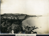 McCarthy Album 08, Photograph 030
 Caption: "Fort Worden Wash.," c. 1908. Overview of Fort Worden in Port Townsend, Washington, on Admiralty Inlet of Puget Sound. Construction began on the fort in 1898, and by 1902 it was serving as an active U.S. Army base. Fort Worden was part of the "triangle of fire," three coastal defense fortifications (Fort Casey, Fort Worden, and Fort Flagler) guarding the entrance to Puget Sound. The U.S. sold the property to the state of Washington in 1957. In 1973, the fort and surrounding area opened as Fort Worden State Park.
-
 McCarthy Album 08, Photograph 029
 Caption: "Target Practice," c. 1908. This postcard shows a plume of seawater thrown up by a mortar shell during target practice at Fort Point. The facilities at Fort Point were part of an effort by the U.S. government to protect the Golden Gate, entrance to the San Francisco Bay. Built between 1853-1861, the fort included emplacements for 141 guns but never fired a weapon in defense of the Bay. Its name was officially changed in 1882 to Fort Winfield Scott, but in 1886 the fort was officially downgraded to a sub-post of the San Francisco Presidio and the name discontinued. It was resurrected in 1912, with the establishment of a coastal artillery fortification at the Presidio, called, once again, Fort Winfield Scott. See also 96-07-08-alb05-322.
-
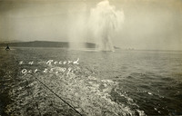 McCarthy Album 08, Photograph 028
 Caption: "#4 -- Record Oct 25, 09." This postcard shows plume of seawater thrown up by a mortar shell during target practice at Fort Point. The facilities at Fort Point were part of an effort by the U.S. government to protect the Golden Gate, entrance to the San Francisco Bay. Built between 1853-1861, the fort included emplacements for 141 guns but never fired a weapon in defense of the Bay. Its name was officially changed in 1882 to Fort Winfield Scott, but in 1886 the fort was officially downgraded to a sub-post of the San Francisco Presidio and the name discontinued. It was resurrected in 1912, with the establishment of a coastal artillery fortification at the Presidio, called, once again, Fort Winfield Scott.
-
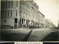 McCarthy Album 08, Photograph 027
 Caption: "Main Street, Port Townsend.," c. 1908-1912. Street scene in Washington's Port Townsend, on the tip of the Olympic Peninsula on the shores of Puget Sound.
-
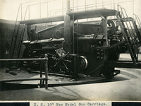 McCarthy Album 08, Photograph 026
 Caption: "U. S. 10" New Model Gun Carriage.," c. 1908-1912. Side view of a coastal defense disappearing gun carriage, without the gun barrel installed. Retracting or disappearing guns were a form of artillery developed in the nineteenth century in which heavy artillery guns were placed on rotating carriages that allowed retraction of the weapon after firing, to enable reloading while under enemy fire.
-
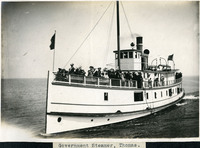 McCarthy Album 08, Photograph 025
 Caption: "Government Steamer, Thomas.," c. 1980-1912. Shows a small steamship or ferry, its deck occupied by a group of unidentified people.
-
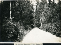 McCarthy Album 08, Photograph 024
 Caption: "Ordnance Avenue, Fort Casey." C. 1908-1912. Rural road lined with thick vegetation and trees.
-
 McCarthy Album 08, Photograph 023
 Caption: "Clife [sic] House S.F.," c. 1908-1912. View of San Francisco's Cliff House overlooking Ocean Beach. The building shown here is the fourth iteration of the Cliff House, a neo-classical design built after a fire destroyed the Victorian structure previously at the site in 1907. Reconstruction of the iconic restaurant began in 1908, and a new Cliff House opened in 1909 (the building in this photograph). This neo-classical building was extensively remodeled in the 1930s.
-
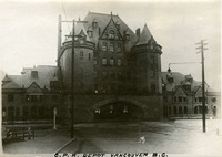 McCarthy Album 08, Photograph 022
 Caption: "C.P.R. Depot Vancouver B.C.," c. 1908-1912. View of the imposing, gothic chateau-like Vancouver Station, serving the Canadian Pacific Railway. Built in 1899, this station only stood until 1914, when it was replaced with a newer facility and subsequently demolished.
-
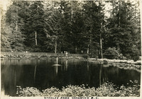
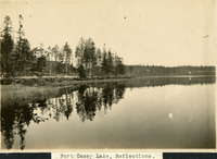 McCarthy Album 08, Photograph 021
 Caption: "Fort Casey Lake, Reflections.," c. 1908-1912. Peaceful scene at Crocket Lake near Fort Casey, the water so still that the trees and surrounding hills are clearly reflected in the lake's waters.
-
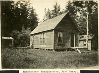 McCarthy Album 08, Photograph 020
 Caption: "Machinists' Headquarters, Fort Casey.," c. 1908-1912. View of building with gabled roof and sides sheathed in wood planks, with a small shed to the left and another small building to the right. Fort Casey was part of the "triangle of fire," three coastal defense fortifications (Fort Casey, Fort Worden, and Fort Flagler) guarding the entrance to Puget Sound. Construction began on the fort in 1897, and the U.S. Army used the facility until the 1950s, when the fort was decommissioned. The area is now a state park.
-
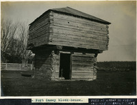 McCarthy Album 08, Photograph 019
 Caption: "Fort Casey block-house." and "USED AS A FORT TO FIGHT INDIANS IN EARLY DAYS," c. 1908-1912. View of a blockhouse, a timber structure built by European settlers to guard against attack during the Indian Wars of 1855-1857. See also 96-07-08-alb08-067.
-
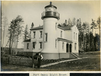 McCarthy Album 08, Photograph 018
 Caption: "Fort Casey Light House [sic]," c. 1905. Located on Whidbey Island in Puget Sound, the Admiralty Head Lighthouse was built overlooking Admiralty Inlet in 1903. It replaced an earlier structure that had to be moved in 1890 to accommodate the construction of Fort Casey. The second lighthouse, shown here, was built with thick walls in order to withstand earthquakes and the concussion of guns at Fort Casey. The man shown in the photograph is likely Charles H. Davis, who was appointed keeper of the lighthouse in 1900 and served until his death in 1914. The lighthouse, deactivated in 1922, has since been restored by Washington State Parks, and is part of the Fort Casey State Park. See also 96-07-08-alb03-065.
-
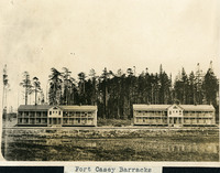 McCarthy Album 08, Photograph 017
 Caption: "Fort Casey Barracks," c. 1908-1912. View of two barracks buildings at Fort Casey, located on Whidbey Island in Puget Sound. Construction began on the fort in 1897. Fort Casey was part of the "triangle of fire," three coastal defense fortifications (Fort Casey, Fort Worden, and Fort Flagler) guarding the entrance to Puget Sound. The U.S. Army used the facility until the 1950s, when the fort was decommissioned. The area is now a state park.
-
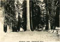 McCarthy Album 08, Photograph 016
 Caption: "Stanley Park Vancouver B.C.," c. 1908-1912. View of what may be a campsite, surrounded by tall trees and featuring a small gazebo and bench. The City of Vancouver opened Stanley Park in 1888. The 405-hectare park is even now thickly forested, and remains Vancouver's largest park. It is located on the northern edge of the city, surrounded on three sides by Vancouver Harbor and English Bay.
-
 McCarthy Album 08, Photograph 015
 Caption: "Stanley Park Vancouver B.C.," c. 1908-1912. Shows a pond with central fountain, surrounded by lush vegetation including evergreen trees. A group of people stands at the pond's edge in the distance. The City of Vancouver opened Stanley Park in 1888. The 405-hectare park is even now thickly forested, and remains Vancouver's largest park. It is located on the northern edge of the city, surrounded on three sides by Vancouver Harbor and English Bay.