-
 McCarthy Album 08, Photograph 159
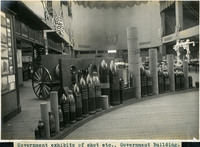
 Caption: "Government exhibits of shot etc., Government Building." Exhibit of various types of heavy ordnance shells, including armor piercing shells as well as torpedoes. The exhibit was located in the Government Building of the Lewis and Clark Centennial Exposition, held in Portland, Oregon from June 1st to October 15th, 1905. It celebrated the one-hundred year anniversary of the exploratory expedition of the Louisiana Purchase and what became the northwestern part of the United States, led by Meriwether Lewis and William Clark. Some 1.6 million people visited the fair, viewing exhibits from twenty-one countries. See also 96-07-08-alb05-206.
-
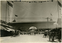
 McCarthy Album 08, Photograph 158
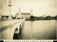
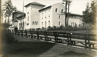
 Caption: "Government Building & Bridge of Nations, Portland Fair." Shows the Government Building, Guild's Lake, and the Bridge of Nations, a long pedestrian bridge over the lake. Some of the more than 100,000 light bulbs used to outline the exposition's buildings can be seen along the arches and decorative molding of the bridge. The Lewis and Clark Centennial Exposition was held in Portland, Oregon from June 1st to October 15th, 1905. It celebrated the one-hundred year anniversary of the exploratory expedition of the Louisiana Purchase and what became the northwestern part of the United States, led by Meriwether Lewis and William Clark. Some 1.6 million people visited the fair, viewing exhibits from twenty-one countries. See also 96-07-08-alb05-206.
-
 McCarthy Album 08, Photograph 157a
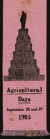
 No Caption: Pink ribbon commemorating Agricultural Days at the Lewis and Clark Centennial Exposition (September 28 and 29, 1905). Held in Portland, Oregon, from June 1st to October 15th, 1905, the international exposition celebrated the one-hundred year anniversary of the exploratory expedition of the Louisiana Purchase and what became the northwestern part of the United States, led by Meriwether Lewis and William Clark. Some 1.6 million people visited the fair, viewing exhibits from twenty-one countries.
-
 McCarthy Album 08, Photograph 157
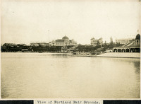
 Caption: "View of Portland Fair Grounds." This photograph shows a panoramic view of the fair grounds where the Lewis and Clark Centennial Exposition was held in Portland, Oregon, from June 1st to October 15th, 1905. The international exposition celebrated the one-hundred year anniversary of the exploratory expedition of the Louisiana Purchase and what became the northwestern part of the United States, led by Meriwether Lewis and William Clark. Some 1.6 million people visited the fair, viewing exhibits from twenty-one countries.
-
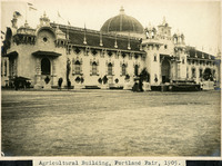 McCarthy Album 08, Photograph 156
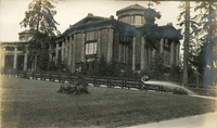
 Caption: "Agricultural Building, Portland Fair, 1905." View of the Agriculture and Horticulture Building at the Lewis and Clark Centennial Exposition. The exposition was held in Portland, Oregon from June 1st to October 15th, 1905. It celebrated the one-hundred year anniversary of the exploratory expedition of the Louisiana Purchase and what became the northwestern part of the United States, led by Meriwether Lewis and William Clark. Some 1.6 million people visited the fair, viewing exhibits from twenty-one countries.
-
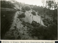 McCarthy Album 08, Photograph 155
 Caption: "Trestle in Oregon, Taken from Observation Car Platform," c. 1910. View of a train crossing a trestle in the Siskiyou Mountains of southern Oregon.
-
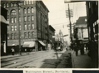 McCarthy Album 08, Photograph 154
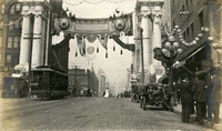
 Caption: "Washington Street, Portland.," c. 1910. Scene on Washington Street in Portland, Oregon, featuring pedestrians, an electric trolley, and a banner noting "Republican Headquarters."
-
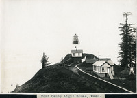 McCarthy Album 08, Photograph 153
 Caption: "Fort Canby Lighthouse, Wash.," c. 1910. View of the Cape Disappointment Lighthouse on a rocky point overlooking the mouth of the Columbia River. Cannons and cannon balls are stored on the lighthouse property. Built in the 1850s, the lighthouse was electrified in 1934 and automated in 1973. The lighthouse is now part of the Cape Disappointment State Park (formerly Fort Canby State Park).
-
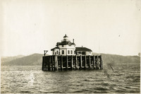 McCarthy Album 08, Photograph 152
 No Caption: c. 1910. View of the Desdemona Lighthouse, constructed in 1901 or 1902 on wood pilings over a group of shoals at the mouth of the Columbia River. The shoals carry the same name as the lighthouse, both of which are named for the bark Desdemona which ran aground and was destroyed by the shoals in 1857. The lighthouse was automated in 1934, and its light eventually removed in 1965.
-
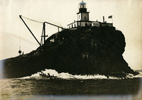 McCarthy Album 08, Photograph 151
 No Caption: c. 1898. View of Tillamook Rock Lighthouse and the small basalt rock upon which it sits, over one mile into the ocean from Tillamook Head. Built between 1880-1881, the treacherous ocean currents and often inclement weather associated with the area earned the lighthouse its nickname "Terrible Tillie" or "Tillie." This photograph was taken before the roof of the lighthouse was raised by five feet in 1898, to help prevent damage to the roof and the interior by crashing waves. The lighthouse was decommissioned in 1957.
-
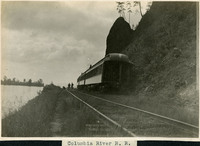 McCarthy Album 08, Photograph 150
 Caption: "Columbia River R. R.," c. 1910. View of railroad tracks along the Columbia River, with some train cars next to a high bank or cliff.
-
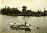 McCarthy Album 08, Photograph 149
 No Caption: c. 1910. View of the Point Adams Lifesaving Station near Hammond, Oregon, including a rowboat ("Point Adams") manned by eight rowers, with one man at the rudder. The Point Adams Lifesaving Station was established in 1889 by the federal government, in response to growing numbers of merchant, fishing, and other sailing vessels along the Columbia River. The stationhouse, visible in the center of the photograph, was demolished in 1939 to make way for a new building. The two-bay boathouse visible at the right had to be moved in 1913-1915 due to erosion of the bank upon which it stood. The U.S. Coastguard took over operation of the station in 1915. The station remained operational until 1967. The remaining buildings now house the Point Adams Research Facility of the Northwest Fisheries Science Center.
-
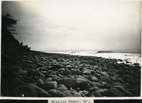 McCarthy Album 08, Photograph 148
 Caption: "Seaside Beach, Or.," undated. View of a rocky ocean beach and ocean breakers.
-
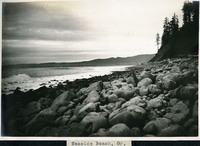 McCarthy Album 08, Photograph 147
 Caption: "Seaside Beach, Or.," undated. View of a rocky ocean beach, with hills in the distance across a small bay. Piles of driftwood appear at the right side of the photograph.
-
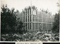 McCarthy Album 08, Photograph 146
 Caption: "Old Landmark, Seaside, Or.," c. 1910. Shows a picket fence erected around what a sign calls "Remains of Cairn where Lewis & Clark made salt from the ocean water Jan. & Feb. 1806." When the famous expedition led by Merriweather Lewis and William Clark reached the Pacific Ocean in late 1805, their supplies had run dangerously low, including their salt supply. Salt, used not only to flavor meat but also to preserve it, was extremely important to the health of the expedition. Three of Lewis and Clark's men traveled to a site on the coast near present-day Seaside, Oregon to set up a small salt-works, boiling ocean water in a series of large kettles and then scraping the resulting salt crust off of the sides. In this manner, the men eventually collected about twenty gallons of salt before Lewis and Clark decided the supply was sufficient for the return journey. In 1910, the property containing the remains of the cairns was deeded to the Oregon Historical Society. In 1955, replica salt cairns were built at the site by the Lions Club to commemorate the expedition's activities.
-
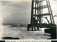 McCarthy Album 08, Photograph 145
 Caption: "Pile Driver in the Breakers, Columbia River Jetty.," c. 1910. View of a large pile driver used in the construction of the jetty system at the mouth of the Columbia River. This is likely at the end of the so-called South Jetty, extending more than six miles into the ocean from Point Adams on the Oregon side of the river mouth. The jetty system at the mouth of the Columbia River was constructed between 1885 and 1917. Designed to funnel water from the Columbia River in a more concentrated fashion into the Pacific Ocean, the jetty system helped create a deeper, more stable shipping channel.
-
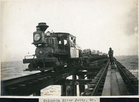 McCarthy Album 08, Photograph 144
 Caption: "Columbia River Jetty, Or.," c. 1910. View of a jetty built at the mouth of the Columbia River, carrying a railroad trestle. A train and its operators, hauling cars loaded with large rocks, dominates the photograph. This is likely the so-called South Jetty, extending more than six miles into the ocean from Point Adams on the Oregon side of the river mouth. The jetty system at the mouth of the Columbia River was constructed between 1885 and 1917. Designed to funnel water from the Columbia River in a more concentrated fashion into the Pacific Ocean, the jetty system helped create a deeper, more stable shipping channel.
-
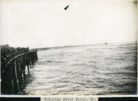
 McCarthy Album 08, Photograph 143
 Caption: "Columbia River Jetty, Or.," c. 1910. View of a jetty built at the mouth of the Columbia River, carrying a railroad trestle. A train hauling cars loaded with large rocks is visible at the left side of the photograph. This is likely the so-called South Jetty, extending more than six miles into the ocean from Point Adams on the Oregon side of the river mouth. The jetty system at the mouth of the Columbia River was constructed between 1885 and 1917. Designed to funnel water from the Columbia River in a more concentrated fashion into the Pacific Ocean, the jetty system helped create a deeper, more stable shipping channel.
-
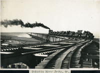
 McCarthy Album 08, Photograph 142
 Caption: "Columbia River Jetty, Or.," c. 1910. View of a jetty built at the mouth of the Columbia River, carrying a railroad trestle. Train cars loaded with large rocks are visible at the left side of the photograph. This is likely the so-called South Jetty, extending more than six miles into the ocean from Point Adams on the Oregon side of the river mouth. The jetty system at the mouth of the Columbia River was constructed between 1885 and 1917. Designed to funnel water from the Columbia River in a more concentrated fashion into the Pacific Ocean, the jetty system helped create a deeper, more stable shipping channel.
-
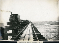
 McCarthy Album 08, Photograph 141
 Caption: "Columbia River Jetty, Or.," c. 1910. View of a jetty built at the mouth of the Columbia River, carrying a railroad trestle. A train hauling cars loaded with large rocks is steaming away from the photographer. This is likely the so-called South Jetty, extending more than six miles into the ocean from Point Adams on the Oregon side of the river mouth. The jetty system at the mouth of the Columbia River was constructed between 1885 and 1917. Designed to funnel water from the Columbia River in a more concentrated fashion into the Pacific Ocean, the jetty system helped create a deeper, more stable shipping channel.
-
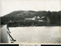 McCarthy Album 08, Photograph 140
 Caption: "Fort Columbia, Wash.," c. 1910. Fort Columbia, built between 1896 and 1904, sits on Chinook Point overlooking the Columbia River. It is part of the Three Fort Harbor Defense System protecting the mouth of the river from enemy incursion or attack (the other forts being Oregon's Fort Stevens and Washington's Fort Canby). Fort Columbia was decommissioned after World War II, and is now the site of a Washington State Park.
-
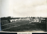 McCarthy Album 08, Photograph 139
 Caption: "Fort Stevens, Or.," c. 1910. View of buildings at Fort Stevens, part of the Three Fort Harbor Defense System protecting the mouth of the Columbia River from enemy incursion or attack (the other forts being Fort Columbia and Fort Canby, both in Washington). Built during the Civil War, the fort remained active until after World War II. In June 1942, Fort Stevens gained the dubious distinction of being the only military installation in the continental United States to come under enemy fire when a Japanese submarine surfaced off the coast and fired seventeen missiles at the fort. The missiles destroyed the backstop to the fort's baseball field, but otherwise did little harm. Fort Stevens was decommissioned in 1947. It was later turned over to the Oregon Parks and Recreation Department, and currently is the site of an Oregon State Park.
-
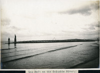 McCarthy Album 08, Photograph 138
 Caption: "Log Raft on the Columbia River.," c. 1909. View of a long raft transporting logs on the Columbia River.
-
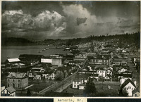 McCarthy Album 08, Photograph 137
 Caption: "Astoria, Or.," c. 1909. Bird's eye view of Astoria, a port city near the mouth of the Columbia River in Oregon.
-
 McCarthy Album 08, Photograph 136
 No Caption: Seattle street scene dominated by a banner welcoming fairgoers to the Alaska-Yukon-Pacific Exposition. Held in Seattle to celebrate the development of the Pacific Northwest, the fair attracted 3.7 million visitors over the course of its run from June to October 1909. Although most of the fair's buildings have since been destroyed, several of them now serve as part of the University of Washington campus.
-
 McCarthy Album 08, Photograph 135
 No Caption: View of the Forestry Building at the Alaska-Yukon-Pacific Exposition. Made out of unpeeled logs, the Forestry Building was demolished in the 1930s. Held in Seattle to celebrate the development of the Pacific Northwest, the fair attracted 3.7 million visitors over the course of its run from June to October 1909. Although most of the fair's buildings have since been destroyed, several of them now serve as part of the University of Washington campus.
-
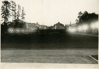
 McCarthy Album 08, Photograph 134
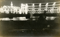
 No Caption: This postcard shows several buildings of the Alaska-Yukon-Pacific Exposition at night, outlined by electric lights. More than 20,000 electric lights were installed on the buildings for the fair. Held in Seattle to celebrate the development of the Pacific Northwest, the fair attracted 3.7 million visitors over the course of its run from June to October 1909. Although most of the fair's buildings have since been destroyed, several of them now serve as part of the University of Washington campus.
-
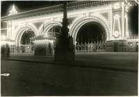
 McCarthy Album 08, Photograph 133
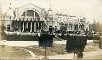
 No Caption: This postcard shows a view of the façade of the Government Building at the Alaska-Yukon-Pacific Exposition. Held in Seattle to celebrate the development of the Pacific Northwest, the fair attracted 3.7 million visitors over the course of its run from June to October 1909. Although most of the fair's buildings have since been destroyed, several of them now serve as part of the University of Washington campus.
-
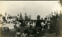 McCarthy Album 08, Photograph 132
 No Caption: View of a portion of the fairgrounds of the Alaska-Yukon-Pacific Exposition in Seattle, showing elegantly attired fairgoers strolling pathways and resting on benches. Held in Seattle to celebrate the development of the Pacific Northwest, the fair attracted 3.7 million visitors over the course of its run from June to October 1909. Although most of the fair's buildings have since been destroyed, several of them now serve as part of the University of Washington campus.
-
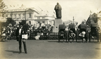 McCarthy Album 08, Photograph 131
 No Caption: A statue of George Washington (Lorado Taft, artist) dominates this photograph of fair-goers at the Alaska-Yukon-Pacific Exposition. Rickshaws and their drivers rest near the statue while waiting for their next fare. Held in Seattle to celebrate the development of the Pacific Northwest, the fair attracted 3.7 million visitors over the course of its run from June to October 1909. Although most of the fair's buildings have since been destroyed, several of them now serve as part of the University of Washington campus.
-
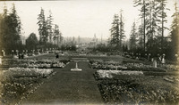 McCarthy Album 08, Photograph 130
 No Caption: View of a garden at the Alaska-Yukon-Pacific Exposition. Held in Seattle to celebrate the development of the Pacific Northwest, the fair attracted 3.7 million visitors over the course of its run from June to October 1909. Although most of the fair's buildings have since been destroyed, several of them now serve as part of the University of Washington campus.
-
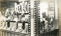 McCarthy Album 08, Photograph 129
 No Caption: Photograph of a display of lemons at the Alaska-Yukon-Pacific Exposition. Held in Seattle to celebrate the development of the Pacific Northwest, the fair attracted 3.7 million visitors over the course of its run from June to October 1909. Although most of the fair's buildings have since been destroyed, several of them now serve as part of the University of Washington campus.
-
 McCarthy Album 08, Photograph 128
 No Caption: View of the California Building at the Alaska-Yukon-Pacific Exposition. Held in Seattle to celebrate the development of the Pacific Northwest, the fair attracted 3.7 million visitors over the course of its run from June to October 1909. Although most of the fair's buildings have since been destroyed, several of them now serve as part of the University of Washington campus. See also 96-07-08-alb05-214.
-
 McCarthy Album 08, Photograph 127
 No Caption: View of the Forestry Building at the Alaska-Yukon-Pacific Exposition. Grace McCarthy is seated on a bench in front of the building, in a light-colored dress and hat. Made out of unpeeled logs, the Forestry Building was demolished in the 1930s. Held in Seattle to celebrate the development of the Pacific Northwest, the fair attracted 3.7 million visitors over the course of its run from June to October 1909. Although most of the fair's buildings have since been destroyed, several of them now serve as part of the University of Washington campus.
-
 McCarthy Album 08, Photograph 126
 No Caption: View of the Manufacturing Building at the Alaska-Yukon-Pacific Exposition. Held in Seattle to celebrate the development of the Pacific Northwest, the fair attracted 3.7 million visitors over the course of its run from June to October 1909. Although most of the fair's buildings have since been destroyed, several of them now serve as part of the University of Washington campus.
-
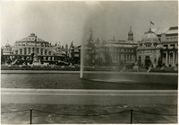
 McCarthy Album 08, Photograph 125
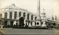
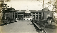
 No Caption: This postcard shows a view of the Government Building and the Cascades (a terraced fountain leading up to the building), part of the Alaska-Yukon-Pacific Exposition. Held in Seattle to celebrate the development of the Pacific Northwest, the fair attracted 3.7 million visitors over the course of its run from June to October 1909. Although most of the fair's buildings have since been destroyed, several of them now serve as part of the University of Washington campus. See also 96-07-08-alb05-212.
-
 McCarthy Album 08, Photograph 124
 No Caption: View of the Alaska-Yukon-Pacific Exposition at dusk, with pathways defined by globe lights. The Government Building can be seen in the center of the photograph. Held in Seattle to celebrate the development of the Pacific Northwest, the fair attracted 3.7 million visitors over the course of its run from June to October 1909. Although most of the fair's buildings have since been destroyed, several of them now serve as part of the University of Washington campus.
-
 McCarthy Album 08, Photograph 123a
 No Caption: White ribbon commemorating Seattle Day at the Alaska-Yukon-Pacific Exposition. Held in Seattle to celebrate the development of the Pacific Northwest, the fair attracted 3.7 million visitors over the course of its run from June to October 1909. Several buildings constructed for the exposition now serve as part of the University of Washington campus.
-
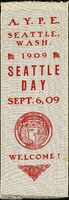
 McCarthy Album 08, Photograph 123
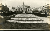
 No Caption: View of the Government Building, neighboring buildings, and Geyser Basin at the Alaska-Yukon-Pacific Exposition. Held in Seattle to celebrate the development of the Pacific Northwest, the fair attracted 3.7 million visitors over the course of its run from June to October 1909. Although most of the fair's buildings have since been destroyed, several of them now serve as part of the University of Washington campus. For instance, Geyser Basin became Drumheller Fountain, now at a slightly different location.
-
 McCarthy Album 08, Photograph 122
 No Caption: Entryway to the Alaska-Yukon-Pacific Exposition as seen at night. Held in Seattle to celebrate the development of the Pacific Northwest, the fair attracted 3.7 million visitors over the course of its run from June to October 1909. Although most of the fair's buildings have since been destroyed, several of them now serve as part of the University of Washington campus.
-
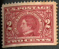 McCarthy Album 08, Photograph 121b
 No Caption: Commemorative U.S. two-cent postage stamp issued for the Alaska-Yukon-Pacific Exposition. The stamp features a portrait of William H. Seward, U.S. Secretary of State (1861-1869), U.S. Senator (1849-1861), and twelfth governor of New York (1839-1842). Seward negotiated the purchase of the Alaskan territory from Russia in 1867.
-
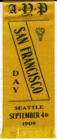 McCarthy Album 08, Photograph 121a
 No Caption: Yellow ribbon commemorating "San Francisco Day" at the Alaska-Yukon-Pacific Exposition. Held in Seattle to celebrate the development of the Pacific Northwest, the fair attracted 3.7 million visitors over the course of its run from June to October 1909. Although most of the fair's buildings have since been destroyed, several of them now serve as part of the University of Washington campus.
-
 McCarthy Album 08, Photograph 121
 No Caption: View of the entryway to the Alaska-Yukon-Pacific Exposition. Held in Seattle to celebrate the development of the Pacific Northwest, the fair attracted 3.7 million visitors over the course of its run from June to October 1909. Although most of the fair's buildings have since been destroyed, several of them now serve as part of the University of Washington campus.
-
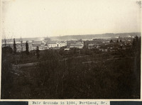 McCarthy Album 08, Photograph 120
 Caption: "Fair Grounds in 1904, Portland, Or." Bird's eye view of the fair grounds in Portland, Oregon.
-
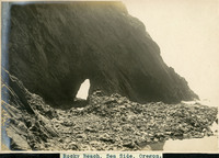 McCarthy Album 08, Photograph 119
 Caption: "Rocky Beach, Sea Side, Oregon.," undated. View of a rocky cliff along a beach in Oregon, with a tunnel carved out by wave action and rubble at the base of the cliff.
-
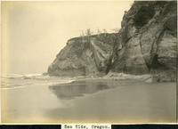 McCarthy Album 08, Photograph 118
 Caption: "Sea Side, Oregon.," undated. View of a beach along the Oregon coastline, with a rocky cliffs and ocean waves breaking.
-
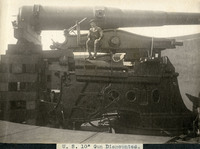 McCarthy Album 08, Photograph 117
 Caption: "U.S. 10" Gun Dismounted.," c. 1905. View from the side of a 10" disappearing gun, a heavy coastal artillery weapon. It has been dismounted from its carriage, with one end held up by timbers. An unidentified man is seated near the barrel of the gun.
-
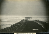 McCarthy Album 08, Photograph 116
 Caption: "Columbia River Jetty, Or.," c. 1905. View of a dilapidated jetty that once carried railroad tracks. Portions of the jetty appear to have been destroyed or washed away.
-
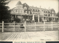 McCarthy Album 08, Photograph 115
 Caption: "Flavel Hotel, Columbia River, Or.," c. 1909. Built at the turn of the century, the Flavel Hotel housed passengers waiting to board steamships of the Great Northern Pacific Steamship Company bound for San Francisco and other ports. The Flavel family constructed the hotel as part of an effort to establish the town of Flavel on Tansy Point along the Columbia River. The town failed to attract sufficient residents, however, and was annexed into Warrenton by 1918. By the time this photograph was taken, the hotel appears to have been abandoned.
-
 McCarthy Album 08, Photograph 114
 Caption: "Ferry Boat Tacoma on the Columbia River.," c. 1905. View of the railroad ferry Tacoma, with a train on board. The Tacoma operated from 1884 until 1908, when a railroad bridge was constructed across the Columbia connecting Portland, Oregon with points north of the river.