-
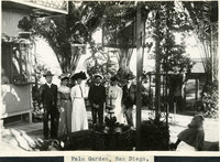 McCarthy Album 08, Photograph 208
 Caption: "Palm Garden, San Diego,," c. 1905. William McCarthy (far right, with moustache) and several unidentified friends or family posing in a garden featuring palm trees and birdcages.
-
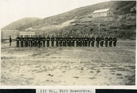 McCarthy Album 08, Photograph 207
 Caption: "115 Co., Fort Rosecrans.," c. 1905. View of the 115th Company of the U.S. Army Coast Artillery Corps, standing in formation. The 115th was formed at the San Diego Barracks in 1901 and subsequently moved to Fort Rosecrans on Point Loma near San Diego. They remained at the fort until 1924 when the company was moved to Puget Sound in Washington.
-
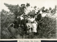 McCarthy Album 08, Photograph 206
 Caption: "Torrey Pines, San Diego.," c. 1905. William McCarthy stands with a group of unidentified friends or family in this photograph, framed within the branches of what appears to be a Torrey pine tree. William is far to the left, sporting a moustache.
-
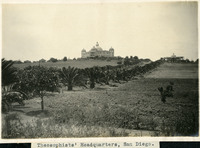 McCarthy Album 08, Photograph 205
 Caption: "Theosophists' Headquarters, San Diego.," c. 1905. Palm-lined driveway leading to two large buildings. The Raja Yoga Academy is visible in the center of the photograph, featuring a domed roof and domed turrets at each of the building's corners. At the right stands the Temple of Peace. Both are buildings within the Theosophist complex called Lomaland. The complex housed Theosophists from 1900 to 1942. The area is now part of Point Loma Nazarene University.
-
 McCarthy Album 08, Photograph 204
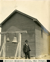
 Caption: "Ancient Mission Bells, San Diego.," c. 1905. In this photograph, William McCarthy stands before “Ancient Mission Bells” at Mission Basilica San Diego de Alcalá (Mission San Diego). Dated 1802, the bells were forged by order of the Spanish King. During the heyday of the missions, the bells were extremely important for signifying when it was time to eat, pray, work, or rest.
-
 McCarthy Album 08, Photograph 203
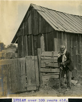
 Caption: "INDIAN over 100 years old," c. 1905. Elderly man, possibly of Native American ethnicity, standing in front of a barn. Taken around 1905 in San Diego near the Old Mission, If William McCarthy's description is accurate, this person was born while California was under Spanish rule. Possibly of the Kumeyaay tribe, whose members had lived in the area long before the Spanish arrived, he may have lived and worked at Mission Basilica San Diego de Alcalá (Mission San Diego) or at a nearby Indian village.
-
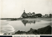
 McCarthy Album 08, Photograph 202
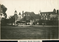
 Caption: "Coronado Hotel Grounds.," c. 1910. View of the Coronado Hotel, with landscaped grounds in the foreground. At the time it opened in 1888, this hotel was the largest beach resort in the world. The Ballroom Tower, the highest point of the building, is 120 feet tall.
-
 McCarthy Album 08, Photograph 201
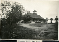
 Caption: "Mission Cliff, San Diego.," c. 1905. View of the pavilion in San Diego's Mission Cliff Gardens. Originally opened in the 1880s as the "Bluffs" by the San Diego Cable Railway Company, the owners hoped to entice people to ride the cable cars by providing a recreational destination. The pavilion seen in the photograph was constructed in 1890. A few years later, the Citizens' Traction Company purchased the park and changed its name to Mission Cliff Park. In 1898, the property was sold yet again, this time to J.D. Spreckels and the San Diego Electric Railway Company. Spreckels hoped to transform the property into a quiet, restful, public botanical garden. The name changed again, to Mission Cliff Gardens, to reflect this change in direction for the park. The botanical gardens developed at the park became world-renowned before closing to the public in 1929. The property was subdivided in 1942, into residential lots.
-
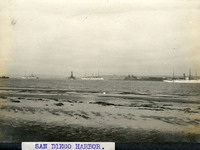 McCarthy Album 08, Photograph 200
 Caption: "SAN DIEGO HARBOR.," c. 1905. View of several ships in San Diego Harbor.
-
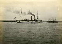 McCarthy Album 08, Photograph 199
 No Caption: c. 1905. View of several ships in San Diego Harbor.
-
 McCarthy Album 08, Photograph 198
 Caption: "Coronado Hotel, San Diego, Cal.," c. 1910-1913. View of the Coronado Hotel, with beach in the foreground. At the time it opened in 1888, this hotel was the largest beach resort in the world. The Ballroom Tower, the highest point of the building, is 120 feet tall. See also 96-07-08-alb05-201.
-
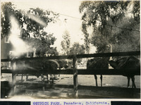 McCarthy Album 08, Photograph 197
 Caption: "OSTRICH FARM, Pasadena, California.," c. 1905. View of several ostriches in a corral at the Caswston Ostrich Farm in Pasadena. Opened by Edward Cawston in 1886, this was the first ostrich farm in the U.S. It became a popular tourist stop along the Pasadena and Los Angeles Electric Railway in the early twentieth century, where visitors could ride an ostrich, or be pulled by one in a light card. They could also buy merchandise made out of ostrich feathers, such as hats and boas. The farm closed in the mid-1930s.
-
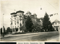 McCarthy Album 08, Photograph 196
 Caption: "Green Hotel, Pasadena, Cal.," c. 1905. View of Castle Green, built as an annex to the Hotel Green in 1899. The original Hotel Green opened for business as a lavish resort in 1894. Its success prompted owner George Gill Green to expand the hotel and build the additional facility shown here, connected to the original hotel by an elaborate enclosed pedestrian bridge (seen at the far right of this photograph). This second building, designed by architect Frederick I. Roehrig with Spanish, Moorish, and Victorian elements, became known as "Castle Green." Business declined in the 1910s, and the complex was sold to a series of investors. In the mid-1920s, Castle Green was subdivided into fifty residential apartments. It remains a residential complex today.
-
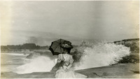 McCarthy Album 08, Photograph 195
 No Caption: c. 1910. Grace McCarthy seated on a rock with crashing surf in the background, at the Vue de L'eau in Santa Cruz. See also 96-07-08-alb07-198.
-
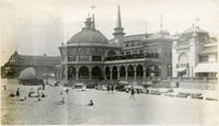 McCarthy Album 08, Photograph 194
 No Caption: c. 1910. View of beach and casino building in Santa Cruz. The casino, designed by William Weeks, was constructed in 1907, replacing a previous casino building that burned down in 1906.
-
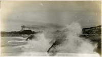
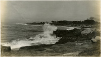 McCarthy Album 08, Photograph 193
 No Caption: c. 1910. Ocean shore scene with waves and high spray, with a promontory in the distance featuring several buildings. The Vue de L'eau (View of the Water) was a station on the Santa Cruz, Garfield Park and Capitola Electric Railway electric streetcar line. Built in 1891, the station was located at the very end of the line, on a promontory overlooking the Pacific Ocean. It featured an observatory on the top story. The same company also built a casino, ballroom, and restaurant nearby. The station burned down in 1925. See also 96-07-08-alb05-159.
-
 McCarthy Album 08, Photograph 192
 No Caption: c. 1910. Ocean shore scene with waves and high spray. The Vue de L'eau (View of the Water) was a station on the Santa Cruz, Garfield Park and Capitola Electric Railway electric streetcar line. Built in 1891, the station was located at the very end of the line, on a promontory overlooking the Pacific Ocean. It featured an observatory on the top story. The same company also built a casino, ballroom, and restaurant nearby. The station burned down in 1925. See also 96-07-08-alb05-074.
-
 McCarthy Album 08, Photograph 191
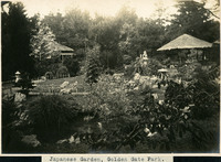
 Caption: "Japanese Garden, Golden Gate Park.," c. 1905. View of the five-acre Japanese Tea Garden in San Francisco's Golden Gate Park. Established in 1894 by George Turner Marsh for the Midwinter Exposition of that year, it is the oldest public Japanese Tea Garden in the U.S.
-
 McCarthy Album 08, Photograph 190
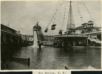
 Caption: "The Chutes, S. F.," c. 1905. View of the Fulton Street Chutes, a 350-foot water slide. Boats or toboggans careened down the slide into a man-made lake at the bottom. Such "chutes" were very popular throughout the U.S. and Europe at the turn of the century. The Fulton Street Chutes operated from 1902-1907 as part of an amusement park area that also featured the "Circle Swing Flying Machine" (also visible in the photograph), a theater, bar, merry-go-round, and a zoo.
-
 McCarthy Album 08, Photograph 189
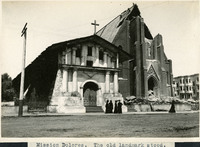
 Caption: "Mission Dolores. The old landmark stood." View of Mission San Francisco de Asís, also known as Mission Dolores. Dedicated in 1791, the adobe mission survived the 1906 earthquake and fire with minor damage, while the brick church right next door was destroyed.
-
 McCarthy Album 08, Photograph 188
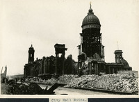
 Caption: "City Hall Ruins." Photograph of the former San Francisco City Hall building, destroyed in the 1906 earthquake and fire.
-
 McCarthy Album 08, Photograph 187
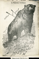
 Caption: "Examiner Cartoon." Photograph of a cartoon that appeared in the San Francisco Examiner in the aftermath of the 1906 earthquake and fire. The cartoon shows a defiant grizzly bear representing San Francisco, pierced by three arrows labeled "Earthquake," "Fire," and "Famine." The word "UNDAUNTED!" appears above the bear.
-
 McCarthy Album 08, Photograph 186
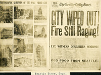
 Caption: "Seattle Times, Copy." Photograph of the front page and an additional page from the Seattle Daily Times, April 20, 1906, in regard to the earthquake and fire that destroyed much of San Francisco on April 18, 1906. The primary headline reads "CITY WIPED OUT! Fire Still Raging!" See also 96-07-08-alb05-020 and 021.
-
 McCarthy Album 08, Photograph 185
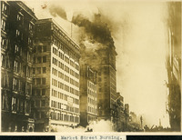
 Caption: "Market Street Burning." Fire engulfing buildings in San Francisco after the 1906 earthquake, including the Call Building.
-
 McCarthy Album 08, Photograph 184
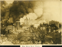
 Caption: "The Fire Down Town." Fire engulfing buildings in San Francisco after the 1906 earthquake. Smoke plumes fill half of the photograph.
-
 McCarthy Album 08, Photograph 183
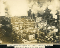
 Caption: "San Francisco April 18, 1906. Center of Town. The Awful Fire after the Shake." Fire engulfing buildings in San Francisco's city center after the 1906 earthquake. Great plumes of smoke dominate the photograph. See also 96-07-08-alb02-025.
-
 McCarthy Album 08, Photograph 182
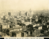
 Caption: "San Francisco April 17, 1906. Center of Town." Bird's eye view of the center of San Francisco before the 1906 earthquake and fire. The Call Building (built in the 1890s to house the San Francisco Call newspaper) is the tallest building in the photograph, just to the right of center. See also 96-07-08-alb02-026.
-
 McCarthy Album 08, Photograph 181
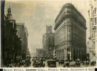
 Caption: "Market Street, Donohoe Bldg., Palace, Grand, Chronicle & Call," c. 1905. View of San Francisco's Market Street, with the Flood Building (built in 1904) prominent in the right side of the photograph.
-
 McCarthy Album 08, Photograph 180
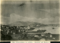
 Caption: "San Francisco in 1849. Center of Town." This photograph shows the central portion of an 1886 lithograph by Henry Firks, depicting San Francisco as it appeared in 1849.
-
 McCarthy Album 08, Photograph 179
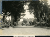
 Caption: "The Alameda of Presidio," c. 1906. View of a dirt or graveled drive, lined by cannonballs, leading to a small roundabout. The Alameda served as the principle gateway into the Presidio of San Francisco from the 1860s to 1895.
-
 McCarthy Album 08, Photograph 178
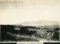
 Caption: "Presidio and Golden Gate.," c. 1906. A birds eye view of the Presidio at San Francisco, California, c. 1906. See also 96-07-08-alb02-024.
-
 McCarthy Album 08, Photograph 177
 Caption: "Presidio Nursery." Image of flower and plant beds at San Francisco's Presidio. One of the beds uses plants and flowers to spell out the word "Presidio."
-
 McCarthy Album 08, Photograph 176
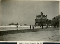
 Caption: "Cliff House Beach, S.F.," c. 1906. Unidentified people enjoying the surf and beach at Ocean Beach, overlooked by the iconic San Francisco Cliff House. The Victorian structure shown here is the third iteration of the Cliff House, constructed in 1896. It was later destroyed by a fire, in 1907.
-
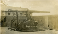
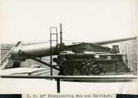 McCarthy Album 08, Photograph 175
 Caption: "U.S. 10" Disappearing Gun and Carriage.," c. 1910. Side view of a coastal defense disappearing gun and its carriage. Retracting or disappearing guns were a form of artillery developed in the nineteenth century in which heavy artillery guns were placed on rotating carriages that allowed retraction of the weapon after firing, to enable reloading while under enemy fire.
-
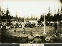 McCarthy Album 08, Photograph 174
 Caption: "R U N N I N G J U M P.," c. 1917. Image of an early high jumper in mid-leap, with men clad in military uniforms watching, as well as civilian men and women. In the high jump, athletes attempt to leap over a horizontal bar without the benefit of a pole (as in pole vaulting). The technique shown here is an early one with the jumper upright rather than in the "Fosbury Flop" position, developed later in the century. The uniforms and surrounding vegetation in the photograph suggest that that event may have taken place at Camp Lewis, Washington.
-
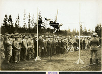 McCarthy Album 08, Photograph 173
 Caption: "SPORTS," c. 1917. Image of a pole vaulter attempting to clear a jump, with rows of men clad in military uniforms observing. The uniforms and the surrounding vegetation suggest that this may have taken place at Camp Lewis, Washington.
-
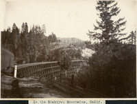 McCarthy Album 08, Photograph 172
 Caption: "In the Siskiyou Mountains, Calif.," c. 1910. View of a train trestle, with the last car of a train passing over it.
-
 McCarthy Album 08, Photograph 171
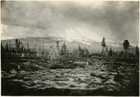
 No Caption: c. 1910. View of Mount Shasta, at the southern end of the Cascade Range, looking east. Mount Shasta has an elevation of 14,179 feet, making it the fifth-highest peak in California. It is also rated as a potential high-risk volcano by the U.S. Geological Survey, and is part of the eastern rim of the Pacific Ring of Fire.
-
 McCarthy Album 08, Photograph 170
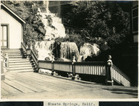
 Caption: "Shasta Springs, Calif.," c. 1910. View of a waterfall behind a small gabled building and attached patio. Shasta Springs, just north of Dunsmuir, California, in the Trinity Mountains, was a resort area in the late nineteenth and early twentieth centuries. It centered around natural springs, which became a featured stop on the Southern Pacific Railroad's Shasta Route. The resort operated until the 1950s, when it was purchased by private interests.
-
 McCarthy Album 08, Photograph 169
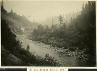
 Caption: "On the Shasta Route, Cal.," c. 1910. Photograph likely taken from an observation car, showing a train running along a creek or river in a mountainous area. Given the caption, this is likely in the Siskiyou Mountains, Trinity Mountains, or the Cascade Range, but the specific location is unidentified.
-
 McCarthy Album 08, Photograph 168
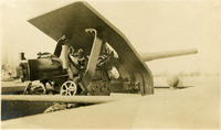
 No Caption: c. 1910. View of a heavy coastal defense artillery gun with a shield protecting the operator of the rotating carriage in which the gun sits.
-
 McCarthy Album 08, Photograph 167
 No Caption: c. 1910. Side view of a heavy coastal defense disappearing gun. Retracting or disappearing guns were a form of artillery developed in the nineteenth century in which heavy artillery guns were placed on rotating carriages that allowed retraction of the weapon after firing, to enable reloading while under enemy fire.
-
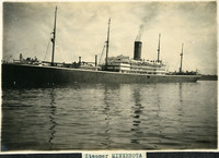 McCarthy Album 08, Photograph 166
 Caption: "Steamer MINNESOTA," c. 1909. View of the steamship Minnesota II, built in 1903. She was said to be the largest U.S. merchant ship afloat at the time. Operated by the Great Northern Steamship Company, she sailed between the U.S. and markets in Asia until 1915. In 1917 the Minnesota II began operating in the Atlantic between the U.S. and the United Kingdom. The U.S. Navy commissioned her as a troop ship in 1919, changing her name to Troy. She brought over 14,000 U.S. troops home from war-torn Europe. She never resumed active service after this, being scrapped in 1923. See also 96-07-08-alb08-111.
-
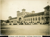 McCarthy Album 08, Photograph 165
 Caption: "Liberal Arts Building, Portland Exposition." View of the Manufactures, Liberal Arts, and Varied Industries Building at the Lewis and Clark Centennial Exposition. The exposition was held in Portland, Oregon from June 1st to October 15th, 1905. It celebrated the one-hundred year anniversary of the exploratory expedition of the Louisiana Purchase and what became the northwestern part of the United States, led by Meriwether Lewis and William Clark. Some 1.6 million people visited the fair, viewing exhibits from twenty-one countries.
-
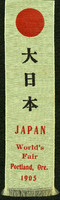 McCarthy Album 08, Photograph 164a
 No Caption: Pale green ribbon with red circle at the top, commemorating the participation of Japan in the Lewis and Clark Centennial Exposition. The exposition was held in Portland, Oregon from June 1st to October 15th, 1905. It celebrated the one-hundred year anniversary of the exploratory expedition of the Louisiana Purchase and what became the northwestern part of the United States, led by Meriwether Lewis and William Clark. Some 1.6 million people visited the fair, viewing exhibits from twenty-one countries.
-
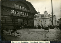 McCarthy Album 08, Photograph 164
 Caption: "Forrestry [sic] Building, Portland Exposition." View of the Forestry Building of the Lewis and Clark Centennial Exposition. Constructed of approximately one million board feet of lumber, including dozens of unpeeled, old-growth tree trunks, the building was purchased by the City of Portland after the Exposition. The building was later destroyed by fire, in 1964. The Lewis and Clark Centennial Exposition was held in Portland, Oregon from June 1st to October 15th, 1905. It celebrated the one-hundred year anniversary of the exploratory expedition of the Louisiana Purchase and what became the northwestern part of the United States, led by Meriwether Lewis and William Clark. Some 1.6 million people visited the fair, viewing exhibits from twenty-one countries.
-
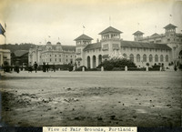 McCarthy Album 08, Photograph 163
 Caption: "View of Fair Grounds, Portland." This photograph shows several buildings of the Lewis and Clark Centennial Exposition, including the Foreign Palace (foreground), the Oriental Palace to its left, and the darkly-colored Forestry Building at the far left. The exposition was held in Portland, Oregon from June 1st to October 15th, 1905. It celebrated the one-hundred year anniversary of the exploratory expedition of the Louisiana Purchase and what became the northwestern part of the United States, led by Meriwether Lewis and William Clark. Some 1.6 million people visited the fair, viewing exhibits from twenty-one countries.
-
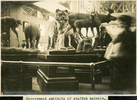 McCarthy Album 08, Photograph 162
 Caption: "Government exhibits of stuffed animals." Various mammals stuffed for display, including a tiger, moose, deer, and antelope, exhibited in the Government Building of the Lewis and Clark Centennial Exposition. The exposition was held in Portland, Oregon from June 1st to October 15th, 1905. It celebrated the one-hundred year anniversary of the exploratory expedition of the Louisiana Purchase and what became the northwestern part of the United States, led by Meriwether Lewis and William Clark. Some 1.6 million people visited the fair, viewing exhibits from twenty-one countries.
-
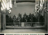 McCarthy Album 08, Photograph 161
 Caption: "Government exhibits of clothing, Government Building." This exhibit demonstrates a variety of military uniforms, displayed on mannequins. It was located in the Government Building of the Lewis and Clark Centennial Exposition, held in Portland, Oregon from June 1st to October 15th, 1905. It celebrated the one-hundred year anniversary of the exploratory expedition of the Louisiana Purchase and what became the northwestern part of the United States, led by Meriwether Lewis and William Clark. Some 1.6 million people visited the fair, viewing exhibits from twenty-one countries.
-
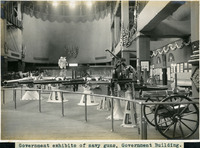 McCarthy Album 08, Photograph 160
 Caption: "Government exhibits of navy guns, Government Building." Shows a variety of naval weaponry. The exhibit was located in the Government Building of the Lewis and Clark Centennial Exposition, held in Portland, Oregon from June 1st to October 15th, 1905. The exposition celebrated the one-hundred year anniversary of the exploratory expedition of the Louisiana Purchase and what became the northwestern part of the United States, led by Meriwether Lewis and William Clark. Some 1.6 million people visited the fair, viewing exhibits from twenty-one countries.