-
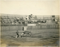
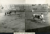 McCarthy Album 08, Photograph 258
 Caption: "Placing the Bandarillias [sic]." Two images pasted into the photograph album next to each other, both showing bulls in a bullring. In both photographs, banderilleros are attempting to place banderillas (short barbed sticks) in each bull's shoulders.
-
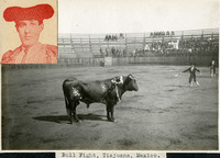 McCarthy Album 08, Photograph 257
 Caption: "Bull Fight, Tiajuana [sic], Mexico." Image is dominated by bull in foreground, with several banderillas (short, barbed sticks) in place on his shoulders. Spectators watch from a ring of seats. A paper image of an unidentified matador is also placed in the album at this location.
-
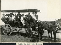 McCarthy Album 08, Photograph 256
 Caption: "Tally Ho Ride, San Diego.," c. 1905. Group of unidentified people in a horse-drawn wagon, with fringed cover. The wagon has "Kelly's Tally-Ho, Cor. 3rd & F Sts." written on one corner.
-
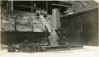
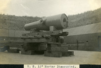 McCarthy Album 08, Photograph 255
 Caption: "U. S. 12" Mortar Dismounted." View of the barrel of a 12-inch mortar, dismounted from its carriage and set upon a tower made of lumber.
-
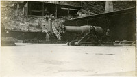
 McCarthy Album 08, Photograph 254
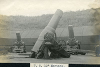
 Caption: "U. S. 12" Mortars." View of three 12-inch mortars in firing position behind an earth and concrete embankment. Caps cover the barrel openings.
-
 McCarthy Album 08, Photograph 253
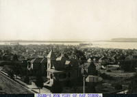
 Caption: "BIRD'S EYE VIEW OF SAN DIEGO," c. 1905. Residences dominate the front portion of this bird's eye view photograph of San Diego, with the harbor in the distance.
-
 McCarthy Album 08, Photograph 252
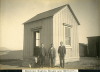
 Caption: "Mexican Custom House and Officer.," c. 1905. William McCarthy (far right) standing in front of a customs house in Mexico, with two other unidentified men. One of the men appears to be of Hispanic ethnicity, and is likely the "Officer" mentioned in the caption.
-
 McCarthy Album 08, Photograph 251
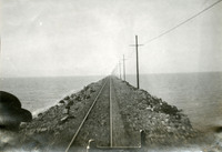
 No Caption: undated. View of train tracks, carried on a levee or jetty, disappearing into the distance, with water on either side.
-
 McCarthy Album 08, Photograph 250
 No Caption: c. 1906. Grace McCarthy posing with an unidentified woman, possibly at a photography studio.
-
 McCarthy Album 08, Photograph 249
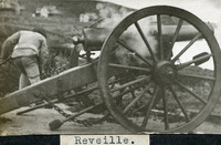
 Caption: "Reveille." Image of a man firing a cannon on a carriage. Given the buildings in the background, this photograph could have been taken at Fort Casey in Washington.
-
 McCarthy Album 08, Photograph 248
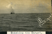
 Caption: "Smashing the Target." and "(8) June 19 -- [illegible]." Image of a plume of water presumably caused by an artillery shell during target practice on an ocean or lake. The date is illegible (mostly cut off).
-
 McCarthy Album 08, Photograph 247
 No Caption: c. 1906. Grace McCarthy posing with an unidentified woman, possibly at a photography studio.
-
 McCarthy Album 08, Photograph 246
 No Caption: undated. View of a heavy artillery coastal defense gun and its carriage. The carriage may be damaged, or in the midst of being constructed.
-
 McCarthy Album 08, Photograph 245
 No Caption: undated. View of two heavy artillery coastal defense guns.
-
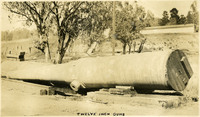 McCarthy Album 08, Photograph 244
 Caption: "Twelve Inch Guns," undated. View of the barrel of a 12-inch heavy artillery gun.
-
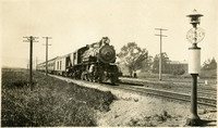 McCarthy Album 08, Photograph 243
 No Caption: undated. View of a locomotive pulling a passenger train in an unidentified location.
-
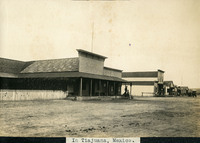 McCarthy Album 08, Photograph 242
 Caption: "In Tiajuana [sic], Mexico.," c. 1905. Street scene in Tijuana, showing several buildings with false fronts along a dirt road.
-
 McCarthy Album 08, Photograph 241
 No Caption: Photograph shows a female bullfighter dodging a bull in a bullring, in Tijuana, Mexico.
-
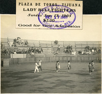 McCarthy Album 08, Photograph 240
 No Caption: Photograph shows five female bullfighters entering a bullring in Tijuana, Mexico. A ticket is pasted in the album above and slightly on top of the photograph, reading "Plaza De Toros, Tijuana, Lady Bullfighters, Sunday Sep 17 1905, $2.00, Good for One Admission."
-
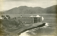 McCarthy Album 08, Photograph 239
 Caption: "Fort Point," c. 1910. This postcard shows a view of Fort Point, at the entrance to San Francisco Bay. The facilities at Fort Point were part of an effort by the U.S. government to protect the Golden Gate, entrance to the San Francisco Bay. Built between 1853-1861, the fort included emplacements for 141 guns but never fired a weapon in defense of the Bay. Its name was officially changed in 1882 to Fort Winfield Scott, but in 1886 the fort was officially downgraded to a sub-post of the San Francisco Presidio and the name discontinued. It was resurrected in 1912, with the establishment of a coastal artillery fortification at the Presidio, called, once again, Fort Winfield Scott.
-
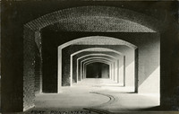 McCarthy Album 08, Photograph 238
 Caption: "Fort Point -- Interior," c. 1910. Postcard showing a view of an interior hall or walkway featuring several arches at Fort Point. The facilities at Fort Point were part of an effort by the U.S. government to protect the Golden Gate, entrance to the San Francisco Bay. Built between 1853-1861, the fort included emplacements for 141 guns but never fired a weapon in defense of the Bay. Its name was officially changed in 1882 to Fort Winfield Scott, but in 1886 the fort was officially downgraded to a sub-post of the San Francisco Presidio and the name discontinued. It was resurrected in 1912, with the establishment of a coastal artillery fortification at the Presidio, called, once again, Fort Winfield Scott.
-
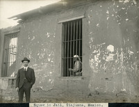 McCarthy Album 08, Photograph 237
 Caption: "Squaw in Jail, Tiajuana [sic], Mexico.," c. 1910. View of a jail in Tijuana, Mexico. An elderly woman is seated behind the bars of one of the windows.
-
 McCarthy Album 08, Photograph 236
 No Caption: c. 1910. Grace McCarthy posing with parasol in garden. See also 96-07-08-alb05-161.
-
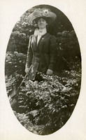
 McCarthy Album 08, Photograph 235
 No Caption: c. 1910. William McCarthy in suit and bowler hat, posing in a garden or park. See also 96-07-08-alb05-155.
-
 McCarthy Album 08, Photograph 234
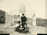
 Caption: "Boundary Monument, Mexican Border." William McCarthy (middle row, far right) and several unidentified people posing in front of an obelisk, one of many Boundary Monuments marking the border between the U.S. and Mexico.
-
 McCarthy Album 08, Photograph 233
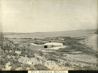
 Caption: "Fort Rosecrans Battery." View of several coastal defense batteries equipped with heavy artillery guns, at Fort Rosecrans near San Diego.
-
 McCarthy Album 08, Photograph 232
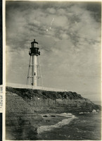
 Caption: "San Diego." View of Point Loma Light. First lit in 1891, this light replaced the "Old Point Loma Lighthouse" that had been constructed in 1855 (see 96-07-08-alb08-225). The old lighthouse was often obscured by fog, so a new lighthouse was built at a lower elevation much closer to sea level, as can be seen in this photograph. The light was automated in 1973. See also 96-07-08-alb05-226.
-
 McCarthy Album 08, Photograph 231
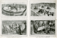
 No Caption: Photograph of part of a print from the Illustrated London News, regarding placement and operation of coastal artillery defense methods. See also 96-07-08-alb05-095.
-
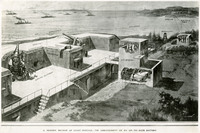 McCarthy Album 08, Photograph 230
 No Caption: Photograph of part of a print from the Illustrated London News, titled "A Modern Method of Coast Defense: The Arrangement of an Up-To-Date Battery." See also 96-07-08-alb05-094.
-
 McCarthy Album 08, Photograph 229
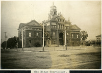
 Caption: "San Diego Courthouse.," c. 1905. View of the second courthouse built by San Diego County, completed in 1889. Designed by architectural firm Cornstock & Trotsche of San Francisco, this elaborate building featured a bell and clock tower, statues of four presidents, and 42 stained-glass windows honoring each state in the Union at the time of installation. The tower was removed in 1939. Twenty years later, the entire building was demolished in favor of a newer facility.
-
 McCarthy Album 08, Photograph 228
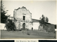
 Caption: "Old Mission, San Diego." William McCarthy standing next to the dilapidated church building of Mission Basilica San Diego de Alcalá (Mission San Diego). The first mission established in the U.S., Mission San Diego was founded by Father Junipero Serra in 1769.
-
 McCarthy Album 08, Photograph 227
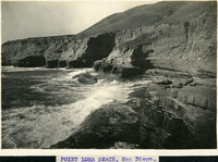
 Caption: "POINT LOMA BEACH, San Diego." View of rocky cliffs and narrow, rocky beach at their base, with surf swirling just offshore.
-
 McCarthy Album 08, Photograph 226
 No Caption: View of Point Loma Light. First lit in 1891, this light replaced the "Old Point Loma Lighthouse" that had been constructed in 1855 (see 96-07-08-alb08-225). The old lighthouse was often obscured by fog, so a new lighthouse was built at a lower elevation much closer to sea level, as can be seen in this photograph. The light was automated in 1973. See also 96-07-08-alb05-232.
-
 McCarthy Album 08, Photograph 225
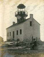
 No Caption: View of the dilapidated Old Point Loma Lighthouse. An unidentified man sits in front of it. Lighted for the first time in 1855, this lighthouse sat on a high cliff above Point Loma near San Diego. Unfortunately, its high elevation resulted in fog or low-lying clouds often obscuring the light. The lighthouse was replaced by a new facility (Point Loma Light -- see 96-07-08-alb08-211 and 226) in 1891. The old lighthouse deteriorated over the years, until being restored in the early 1930s. It is now a museum.
-
 McCarthy Album 08, Photograph 224
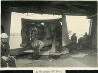
 Caption: "A Chicago 8" Gun." View of an 8" gun on the USS Chicago. Several crew members are visible in the photograph as well.
-
 McCarthy Album 08, Photograph 223
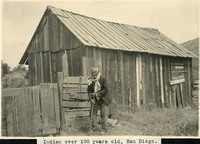
 Caption: "Indian over 100 years old," c. 1905. Elderly man, possibly of Native American ethnicity, standing in front of a barn. Taken around 1905 in San Diego near the Old Mission, If William McCarthy's description is accurate, this person was born while California was under Spanish rule. Possibly of the Kumeyaay tribe, whose members had lived in the area long before the Spanish arrived, he may have lived and worked at Mission Basilica San Diego de Alcalá (Mission San Diego) or at a nearby Indian village.
-
 McCarthy Album 08, Photograph 222
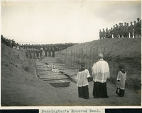
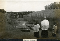
 Caption: "Bennington's Honored Dead." Shows a grave site with dozens of caskets ready for burial. A priest and two altar boys stand at one side of the caskets, while a large group of U.S. Navy sailors looks on from the other side. While sailing from port in San Diego on the morning of July 21, 1905, the boiler of the USS Bennington exploded, killing sixty-six of her crew. The victims were laid to rest in the cemetery at Fort Rosecrans. See also 96-07-08-alb05-142 and 96-07-08-alb08-217.
-
 McCarthy Album 08, Photograph 221
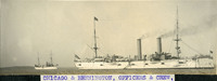
 Caption: "CHICAGO AND BENNINGTON, OFFICERS & CREW." View of the USS Chicago. The flagship of the US fleet in the Pacific at the time, the USS Chicago was called to the fort after a boiler explosion on the USS Bennington killed sixty-six and wounded dozens more. A board of inquiry into the cause of the explosion was convened on board the Chicago. The board found that no error on the part of the Bennington's crew contributed to the explosion.
-
 McCarthy Album 08, Photograph 220
 No Caption: U.S. Naval officers and sailors at the memorial for the victims of the USS Bennington's boiler explosion. The hump of a large mass grave dominates the foreground.
-
 McCarthy Album 08, Photograph 219
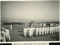
 Caption: "Bennington Memorial, Fort Rosecrans." This photograph shows lines of U.S. Navy sailors in dress uniform at a memorial service for the victims of the USS Bennington's boiler explosion. The hump of a large mass grave can be seen to the left of center.
-
 McCarthy Album 08, Photograph 218
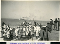
 Caption: "CHICAGO BOYS LANDING AT FORT ROSECRANS." View of US Navy sailors coming ashore at Fort Rosecrans. The flagship of the US fleet in the Pacific at the time, the USS Chicago was called to the fort after a boiler explosion on the USS Bennington killed sixty-six and wounded dozens more. A board of inquiry into the cause of the explosion was convened on board the Chicago. The board found that no error on the part of the Bennington's crew contributed to the explosion.
-
 McCarthy Album 08, Photograph 217
 Caption: "Last Rites." Shows a grave site with dozens of caskets ready for burial. A priest and two altar boys stand at one side of the caskets, while a large group of U.S. Navy sailors looks on from the other side. While sailing from port in San Diego on the morning of July 21, 1905, the boiler of the USS Bennington exploded, killing sixty-six of her crew. The victims were laid to rest in the cemetery at Fort Rosecrans. See also 96-07-08-alb05-142 and 96-07-08-alb08-222.
-
 McCarthy Album 08, Photograph 216
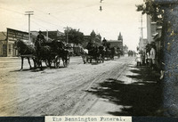
 Caption: "The Bennington Funeral." Shows several wagons loaded with caskets covered with American flags. This was the funeral procession for the victims of the USS Bennington's boiler explosion, which killed 66 of her crew on July 21, 1905. Solemn citizens line the roadway.
-
 McCarthy Album 08, Photograph 215
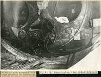
 Caption: "U. S. S. Bennington (Exploded Boiler)" and "on July 21, boiler B exploded, being forced aft against the bulkhead between the fore and aft compartments." View of the exploded boiler of the USS Bennington. On July 21, 1905, while in San Diego Harbor, the Bennington's boiler exploded, killing sixty-six men and injuring many more.
-
 McCarthy Album 08, Photograph 214
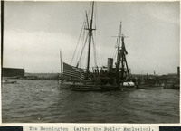
 Caption: "The Bennington (after the Boiler Explosion)." View of the USS Bennington, a U.S. Navy gunboat, Yorktown class, launched in 1890. She had tours of duty in South America, the Mediterranean, North and Central America, Hawaii, and the Philippines. On July 21, 1905, while in San Diego Harbor, the Bennington's boiler exploded, killing sixty-six men and injuring many more. Taken after the explosion, in this photograph the Bennington sits low in the water.
-
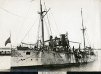 McCarthy Album 08, Photograph 213
 Caption: "The Bennington." View of the USS Bennington, a U.S. Navy gunboat, Yorktown class, launched in 1890. She had tours of duty in South America, the Mediterranean, North and Central America, Hawaii, and the Philippines. On July 21, 1905, while in San Diego Harbor, the Bennington's boiler exploded, killing sixty-six men and injuring many more. This photograph appears to have been taken after the explosion.
-
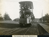 McCarthy Album 08, Photograph 212
 Caption: "Coronado Double Decker.," c. 1905. View of Car #41, a two-level trolley car operated by the San Diego Electric Railway in Coronado.
-
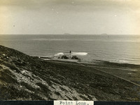 McCarthy Album 08, Photograph 211
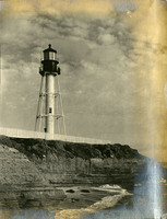
 Caption: "Point Loma.," c. 1905. View of Point Loma and the so-called "New Point Loma Lighthouse" in the center. The lighthouse, first lit in 1891, replaced the "Old Point Loma Lighthouse" that had been constructed in 1855. The old lighthouse was often obscured by fog, so a new lighthouse was built at a much lower elevation much closer to sea level. The light was automated in 1973.
-
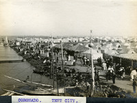 McCarthy Album 08, Photograph 210
 Caption: "CORONADO. TENT CITY.," c. 1910. View of rows of tents and sheds thatched in palm fronds along the coast near Coronado Hotel, with people strolling along the roadways. Established in 1900 for travelers who could not afford to stay in the resort hotel, the Coronado Tent City consisted of a grid of streets lined with furnished tents, near the sea shore. It also featured restaurants, a library, soda fountain, theater, bandstand, and other recreational facilities. See also 96-07-08-alb05-202 and 96-07-08-alb08-263.
-
 McCarthy Album 08, Photograph 209
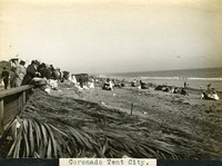
 Caption: "Coronado Tent City.," c. 1910. Beach scene near the Coronado Hotel, showing groups of people enjoying a day at the sea shore. Established in 1900 for travelers who could not afford to stay in the resort hotel, the Coronado Tent City consisted of a grid of streets lined with furnished tents, near the sea shore. It also featured restaurants, a library, soda fountain, theater, bandstand, and other recreational facilities.