-
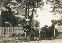 McCarthy Album 06, Photograph 038
 No caption. Grace McCarthy siting in a horse-drawn buggy in front of the McCarthy home in Watsonville, c. 1906.
-
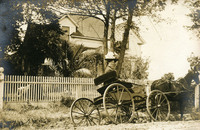 McCarthy Album 06, Photograph 037
 No caption. Grace McCarthy siting in a horse-drawn buggy in front of the McCarthy home in Watsonville, c. 1906.
-
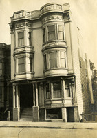 McCarthy Album 06, Photograph 036
 No caption. The façade of an Italianate building that appears to be of mixed residential and commercial use in San Francisco. The sign on the building reads "The Kinriu Co. Wholesale Baskets and Matting Import Silk & Tea," c. 1906.
-
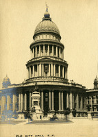 McCarthy Album 06, Photograph 035
 Caption: "Old City Hall S.F." c. 1906. Pictured is the San Francisco City Hall just days before it was destroyed by the 1906 earthquake and fires.
-
 McCarthy Album 06, Photograph 034
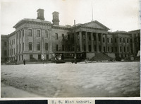
 Caption: "U.S. Mint unhurt," c. 1906. Pictured is the U.S. Mint building in San Francisco, which opened in 1874, after the original 1854 building was outgrown, which had been established to serve the gold mines during the California Gold Rush. The building suffered little damage after the 1906 earthquake. The facility served as the San Francisco U.S. Mint until 1937, when workers moved to a larger and more modern building. In 1961, the old U.S. Mint, known as the "Granite Lady," was designated a National Historic Landmark.
-
 McCarthy Album 06, Photograph 033
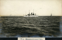
 Caption: "The Massachusetts," c. 1910, was a large ship designed for coastal defense.
-
 McCarthy Album 06, Photograph 032
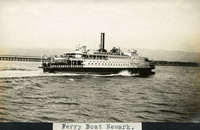
 Caption: "Ferry Boat Newark." c. 1910, shows the Southern Pacific's ferryboat Newark in the San Francisco Bay.
-
 McCarthy Album 06, Photograph 031
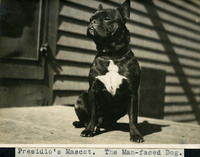
 Caption: "Presidio's Mascot. The Man-faced Dog.," c. 1910, shows a small black and white dog sitting on a porch at the Presidio in San Francisco.
-
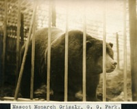 McCarthy Album 06, Photograph 030
 Caption: "Mascot Monarch Grizzly, G. G. Park," c. 1910. Captured in 1889, by a man hired by William Randolph Hearst as a publicity stunt, Monarch was one of the last known Grizzly bears in California. He lived in captivity for the last 22 years of his life, mostly in an enclosure in Golden Gate Park, before he died in 1911.
-
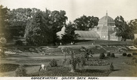 McCarthy Album 06, Photograph 029
 Caption: "Conservatory Golden Gate Park," c. 1910. Built in 1879, the Conservatory is the oldest building in Golden Gate Park, and the oldest municipal wooden conservatory in the country.
-
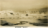 McCarthy Album 06, Photograph 028
 Caption: "Bakers [sic] Beach," c. 1906. Baker Beach begins just south of Golden Gate Point and extends approximately one half-mile southward to Seacliff Peninsula.
-
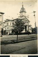 McCarthy Album 06, Photograph 027
 Caption: "Oakland City Hall," c. 1906. Pictured is Oakland's old City Hall at 14th and Broadway. Upon the completion of the new and current city hall in 1914, the old city hall was demolished to make way for City Hall Plaza, now Frank H. Ogawa Plaza.
-
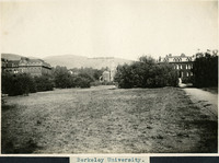 McCarthy Album 06, Photograph 026
 Caption: "Berkeley University," c. 1906. Founded in 1868, the University of California at Berkeley was the first of the University of California campuses. This image shows a field of grass and trees in the foreground, three unidentified university buildings in the background, and the Berkeley Hills in the distance.
-
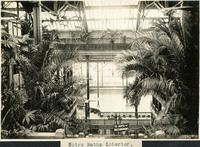 McCarthy Album 06, Photograph 025
 Caption: "Sutro Baths Interior," c. 1906. Designed by Adolph Sutro in 1894, the bathhouses at one time covered three oceanfront acres just north of Ocean Beach and the Cliff House. Eventually, the Sutro Baths fell into disrepair and what was left of them burned down in 1966. Since 1973, the concrete ruins have been part of the Golden Gate National Recreation Area.
-
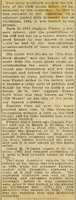 McCarthy Album 06, Photograph 024a
 No Caption. An unidentified newspaper article detailing a brief history of the Cliff House the day after it was destroyed by fire in 1907.
-
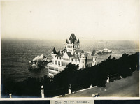 McCarthy Album 06, Photograph 024
 Caption: "The Cliff House," c. 1906 view of San Francisco's Cliff House from Sutro Heights Park. The Victorian structure shown here is the third building on the site, constructed in 1896. It was destroyed by fire in 1907.
-
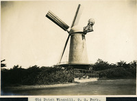 McCarthy Album 06, Photograph 023
 Caption: "Old Dutch Windmill, G.G. Park," c. 1910. Image of the Dutch Windmill in Golden Gate Park, built in 1903 to pump ground water within the park for irrigation purposes.
-
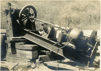
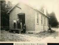 McCarthy Album 06, Photograph 022
 Caption: "Ordnance Machine Shop. Presidio," c. 1906. William McCarthy (far right) and two unidentified men standing in front of the ordnance machine shop at the Presidio.
-
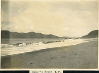 McCarthy Album 06, Photograph 021
 Caption: "Baker's [sic] Beach S.F.," c. 1906. Baker Beach begins just south of Golden Gate Point and extends approximately one half-mile southward to Seacliff Peninsula.
-
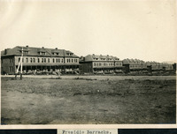 McCarthy Album 06, Photograph 020
 Caption: "Presidio Barracks," c. 1906. Five barrack structures of the Presidio. Established in 1776 by Spanish explorers, the Presidio is a fortified location overlooking the Golden Gate, the entrance into San Francisco Bay. It was closed as a military structure in 1995, and is now a park within the Golden Gate National Recreation Area.
-
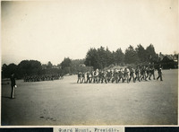 McCarthy Album 06, Photograph 019
 Caption: "Guard Mount. Presidio," c. 1906, shows two groups of men in formation on the Presidio grounds. One group of men is playing musical instruments, while the other group is carrying firearms. Established in 1776 by Spanish explorers, the Presidio is a fortified location overlooking the Golden Gate, the entrance into San Francisco Bay. It was closed as a military structure in 1995, and is now a park within the Golden Gate National Recreation Area.
-
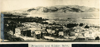
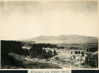 McCarthy Album 06, Photograph 018
 Caption: "Presidio and Golden Gate," c. 1906. A high vantage point view of the Presidio and Golden Gate. Established in 1776 by Spanish explorers, the Presidio is a fortified location overlooking the Golden Gate, the entrance into San Francisco Bay. It was closed as a military structure in 1995, and is now a park within the Golden Gate National Recreation Area.
-
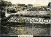 McCarthy Album 06, Photograph 017
 Caption: "Presidio Nursery," c. 1906, shows the gardens at the Presidio, with blooming flowers planted to spell "PRESIDIO."
-
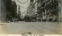 McCarthy Album 06, Photograph 016
 Caption: "Market St. S.F. Calif." See also 96-07-08-alb05-136, with caption: "Market St. Sept 9. 1910 S.F." Market Street in San Francisco, decked with bunting and flags for California's Admissions Day, the anniversary of the Golden State's entry as a state in the U.S.
-
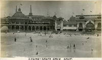 McCarthy Album 06, Photograph 015
 Caption: "Casino-Santa Cruz Calif.," c. 1910. View of beach and casino building in Santa Cruz. The casino, designed by William Weeks, was constructed in 1907, replacing a previous casino building that burned down in 1906.
-
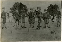 McCarthy Album 06, Photograph 014
 Caption: "Guard mount of the 2nd Squadron, 8th Cavalry, at Fort Huachuca, Aug -- Taken from life, McNally, 1909." A photograph of a drawing of seven men of the 2nd Squadron, 8th Cavalry at Fort Huachuca in Arizona, apparently conducting military maneuvers.
-
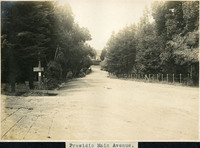 McCarthy Album 06, Photograph 013
 Caption: "Presidio Main Avenue," c. 1906, shows a tree lined dirt road in the Presidio. Established in 1776 by Spanish explorers, the Presidio is a fortified location overlooking the Golden Gate, the entrance into San Francisco Bay. It was closed as a military structure in 1995, and is now a park within the Golden Gate National Recreation Area.
-
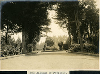 McCarthy Album 06, Photograph 012
 Caption: "The Alameda of Presidio," c. 1906, shows the entryway to the Presidio, lined with cannonballs. Established in 1776 by Spanish explorers, the Presidio is a fortified location overlooking the Golden Gate, the entrance into San Francisco Bay. It was closed as a military structure in 1995, and is now a park within the Golden Gate National Recreation Area.
-
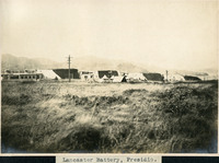 McCarthy Album 06, Photograph 011
 Caption: "Lancaster Battery, Presidio," c. 1906, shows a distant view of Lancaster Battery. Established in 1776 by Spanish explorers, the Presidio is a fortified location overlooking the Golden Gate, the entrance into San Francisco Bay. It was closed as a military structure in 1995, and is now a park within the Golden Gate National Recreation Area.
-
 McCarthy Album 06, Photograph 010
 Caption: "Presidio and Golden Gate," c. 1906, shows many Presidio buildings pictured in the foreground, with ships in the bay. Established in 1776 by Spanish explorers, the Presidio is a fortified location overlooking the Golden Gate, the entrance into San Francisco Bay. It was closed as a military structure in 1995, and is now a park within the Golden Gate National Recreation Area.
-
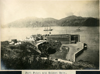 McCarthy Album 06, Photograph 009
 Caption: "Fort Point and Golden Gate," c. 1906. Fort Point in the foreground, with ships in the bay. Fort Point was part of an effort by the U.S. government to protect the Golden Gate, entrance to the San Francisco Bay. Built between 1853-1861 of brick and mortar, the fort included emplacements for 141 guns but never fired a weapon in defense of the Bay.
-
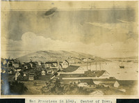
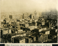 McCarthy Album 06, Photograph 008
 Caption: "San Francisco April 17, 1906. Center of Town," shows a view of the center of San Francisco from a high vantage point, taken on April 17, 1906, the day before the 1906 earthquake and fires devastated the city.
-
 McCarthy Album 06, Photograph 007
 Caption: "San Francisco in 1849. Center of Town." A photograph of a drawing or painting of early San Francisco by an unidentified artist.
-
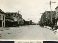 McCarthy Album 06, Photograph 006
 Caption: "Main Street, Watsonville," c. 1906. A view of a sparsely populated Main Street, with buggies and people in the distance.
-
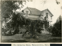 McCarthy Album 06, Photograph 005
 Caption: "The McCarthy Home, Watsonville, Cal," c. 1906. A view of the façade of the crossed-gabled McCarthy home, with large front porch and lush vegetation.
-
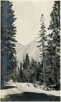
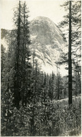 McCarthy Album 06, Photograph 004
 No caption. Photograph of a forest in the foreground and a granite mountain in the distance, at an unidentified location.
-
 McCarthy Album 06, Photograph 003
 No caption. Photograph of a waterfall in a mountainous, unidentified location.
-
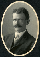 McCarthy Album 06, Photograph 002
 No caption, c. 1910. Portrait photograph of William McCarthy.
-
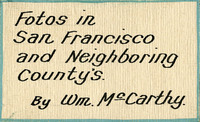 McCarthy Album 06, Photograph 001a
 Caption: "Fotos in San Francisco and Neighboring County's [sic] By Wm. McCarthy." A handwritten label mounted on the first page of the photograph album.
-
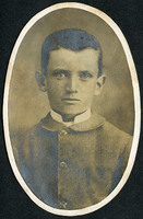 McCarthy Album 06, Photograph 001
 No caption, c. 1890. Photograph portrait of William McCarthy as a young boy.
-
 McCarthy Album 08, Photograph 268
 No Caption: undated. Photograph shows what appears to be part of the carriage of a heavy coastal artillery gun.
-
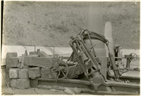 McCarthy Album 08, Photograph 267
 No Caption: undated. Photograph shows the base of what appears to be a 12" mortar, and part of its carriage.
-
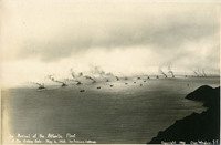 McCarthy Album 08, Photograph 266
 Caption: "The Arrival of the Atlantic Fleet at the Golden Gate -- May 6, 1908. San Francisco, California." and "Copyright 1908, Chas. Weidner, S.F." This photograph, by Charles Weidner, shows the U.S. Navy's Atlantic Fleet, consisting of sixteen battle cruisers and various support vessels, steaming toward the Golden Gate and San Francisco Bay. President Theodore Roosevelt ordered the Atlantic Fleet (later called the "Great White Fleet" because the ships were painted white with gold trim) on a tour around the world, beginning in December 1907, to show American goodwill and also demonstrate the power of the U.S. Navy. The Fleet reached the Golden Gate, entrance to San Francisco Bay, on May 6, 1908.
-
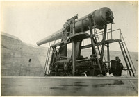 McCarthy Album 08, Photograph 265
 No Caption: undated. Photograph shows what appears to be a 12" disappearing coastal artillery gun, mounted on a rotating carriage.
-
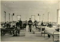 McCarthy Album 08, Photograph 264
 No Caption: c. 1905. Military barracks with two rows of beds, several of which are occupied by unidentified men in uniforms. Other unidentified, uniformed men sit or stand around the beds.
-
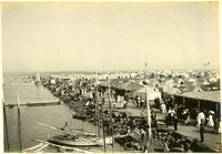 McCarthy Album 08, Photograph 263
 No Caption: c. 1910. View of rows of tents and sheds thatched in palm fronds along the coast near Coronado Hotel, with people strolling along the roadways. Established in 1900 for travelers who could not afford to stay in the resort hotel, the Coronado Tent City consisted of a grid of streets lined with furnished tents, near the sea shore. It also featured restaurants, a library, soda fountain, theater, bandstand, and other recreational facilities. See also 96-07-08-alb05-202 and 96-07-08-alb08-210.
-
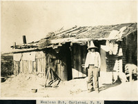 McCarthy Album 08, Photograph 262
 Caption: "Mexican Hut, Carlsbad, N. M.," c. 1905. Shack made out of wood boards and miscellaneous other items, with an unidentified man, possibly of Hispanic ethnicity, standing in front.
-
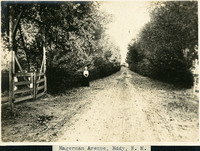 McCarthy Album 08, Photograph 261
 Caption: "Hagerman Avenue, Eddy, N. M.," c. 1905. view of a country road lined with bushes or trees, in Eddy County, New Mexico. An unidentified woman stands in the center of the photograph in the middle distance.
-
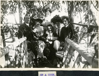 McCarthy Album 08, Photograph 260
 Caption: "UP A TREE,," c. 1905. William McCarthy (center) posing with several unidentified friends and/or family members in a small patio or treehouse.
-
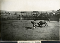 McCarthy Album 08, Photograph 259
 Caption: "Sidestepping the Bull." In this photograph, a bull attempts to gore a matador holding a cape, observed by dozens of people in the surrounding stands.