-
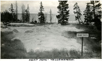 McCarthy Album 09, Photograph 028
 Caption: "Paint Pots - Yellowstone," c. 1923. View of bubbling pools of mud known as mudpots or "paint pots" at Yellowstone National Park.
-
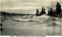 McCarthy Album 09, Photograph 027
 Caption: "Paint Pots or Boiling Clay - Yellowstone," c. 1923. Several unidentified park-goers view bubbling pools of mud known as mudpots or "paint pots" at Yellowstone National Park.
-
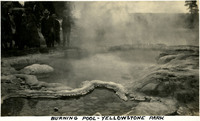 McCarthy Album 09, Photograph 026
 Caption: "Burning Pool - Yellowstone Park," c. 1923. An unidentified group of people walk past Burning Pool at Yellowstone National Park, a thermally active spring in the park's Upper Basin.
-
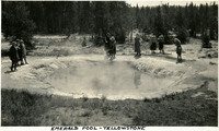 McCarthy Album 09, Photograph 025
 Caption: "Emerald Pool Yellowstone," c. 1923. Grace McCarthy (fourth from the right) and several unidentified people admire Emerald Pool in Yellowstone National Park. The pool, sometimes called Emerald Spring, is located in the park's Black Sand Basin. Yellow sulphur deposits, combined with the blue of the water, give the pool a vivid green color.
-
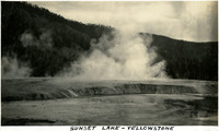 McCarthy Album 09, Photograph 024
 Caption: "Sunset Lake - Yellowstone," c. 1923. Yellowstone National Park's Sunset Lake is a shallow thermal pool in the Black Sand Basin. Its name is derived from the yellow and orange bands of bacteria and algae at its edges.
-
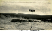 McCarthy Album 09, Photograph 023
 Caption: "Tea Kettle - Yellowstone," c. 1923. Teakettle Spring is a thermally active site in Yellowstone National Park's Upper Geyser Basin.
-
 McCarthy Album 09, Photograph 022
 Caption: "Rocket Geyser," c. 1923. The Rocket Geyser in Yellowstone National Park is part of the Grotto Geyser group, along with Grotto Fountain Geyser (which can also be seen at the right in this photograph), South Grotto Fountain Geyser, Indicator Spring, and Spa Geyser.
-
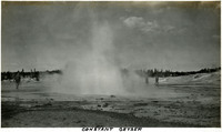 McCarthy Album 09, Photograph 021
 Caption: "Constant Geyser," c. 1923. Three unidentified people circle Constant Geyser in Yellowstone National Park, so named for its frequent eruptions.
-
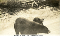 McCarthy Album 09, Photograph 020
 Caption: "Bear & Cub - In Yellowstone," c. 1923. A bear and her cub cross a road or trail in Yellowstone National Park.
-
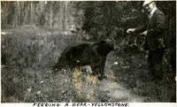 McCarthy Album 09, Photograph 019
 Caption: "Feeding a Bear - Yellowstone," c. 1923. William McCarthy feeding a bear at Yellowstone National Park.
-
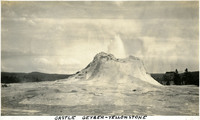 McCarthy Album 09, Photograph 018
 Caption: "Castle Geyser - Yellowstone," c. 1923. Castle Geyser erupting in Yellowstone National Park. The geyser's name refers to the shape of the cone around the vent.
-
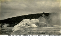 McCarthy Album 09, Photograph 017
 Caption: "Old Faithful Geyser After Eruption - Yellowstone," c. 1923. Grace McCarthy stands behind the vent of Old Faithful, a cone geyser at Yellowstone National Park.
-
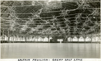 McCarthy Album 09, Photograph 016
 Caption: "Saltair Pavilion - Great Salt Lake," c.1923. Interior of the Saltair Pavilion on Utah's Great Salt Lake. Constructed in 1893 and designed by Richard K.A. Kletting, the Saltair resort set out to be the Western counterpart of Coney Island. The resort was a popular spot for Mormon families, only fifteen miles from Salt Lake City and overseen by Church leaders. The Church sold the building in 1906. It was later destroyed by fire in 1925, but a second pavilion was quickly built.
-
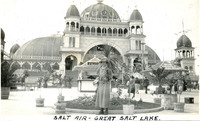 McCarthy Album 09, Photograph 015
 Caption: "Salt Air - Great Salt Lake," c.1923. Grace McCarthy poses in front of the Saltair resort complex on Utah's Great Salt Lake. Constructed in 1893 and designed by Richard K.A. Kletting, the Saltair set out to be the Western counterpart of Coney Island. The resort was a popular spot for Mormon families, only fifteen miles from Salt Lake City and overseen by Church leaders. The Church sold the building in 1906. It was later destroyed by fire in 1925, but a second pavilion was quickly built.
-
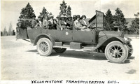 McCarthy Album 09, Photograph 014
 Caption: "Yellowstone Transportation Bus," c. 1923. William and Grace McCarthy (second row from the back, middle and right-hand seats) and a group of unidentified people stop for a photograph while sitting in an eleven-passenger, open-roofed touring bus in Yellowstone National Park. The touring bus, likely made by White Motor Company, was one of a fleet of such vehicles maintained by the Yellowstone Park Transportation Company.
-
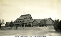 McCarthy Album 09, Photograph 013
 Caption: "Old Faithful Inn - Yellowstone," c. 1923. View of the massive Old Faithful Inn in Yellowstone National Park. Designed by Robert C. Reamer and completed in 1904, the hotel is one of the largest log buildings in the world.
-
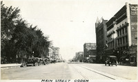 McCarthy Album 09, Photograph 012
 Caption: "Main Street Ogden," c. 1923. Street scene in Ogden, showing a broad roadway used by pedestrians and automobiles, flanked by trees on the left and businesses on the right.
-
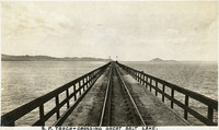 McCarthy Album 09, Photograph 011
 Caption: "S.P. Track - Crossing Great Salt Lake.," c. 1923. The Southern Pacific Railroad constructed the trestle shown in this photograph, known as the Lucin Cutoff, between 1902 to 1904. It crosses the Great Salt Lake, between Ogden and Lucin. The trestle was replaced by a causeway of dirt and rock in the 1950s.
-
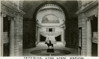 McCarthy Album 09, Photograph 010
 Caption: "Interior Utah State Capitol," c. 1923. This photograph shows part of the main corridor of Utah's State Capitol Building, featuring an equestrian statue of Chief Washakie, leader of the eastern Shoshone (artist unknown). Visible above the entrance to the chambers of the House of Representatives is a mural painted by Gerard Hale and Gilbert White entitled Reclaiming the Desert for Irrigation.
-
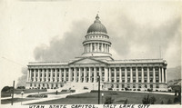 McCarthy Album 09, Photograph 009
 Caption: "Utah State Capitol. Salt Lake City." c. 1923. View of Utah's State Capitol Building, designed by Richard K.A. Kletting and built between 1912 and 1916.
-
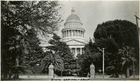 McCarthy Album 09, Photograph 008
 Caption: "State Capitol - Calif, " c. 1920. View of the California State Capitol Building. Much of the building is obscured by trees, but the dome is visible. Designed by M.F. Butler, California's State Capitol Building experienced significant delays while under construction. Crews broke ground on December 4, 1856, but the Legislature did not occupy the building until 1869, and the building was not fully completed until 1874.
-
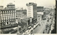 McCarthy Album 09, Photograph 007
 Caption: "Market Street S.F," c. 1935. A bustling Market Street scene with many people, cars and trollies. San Francisco's Ferry Building can be seen in the distance at the far right.
-
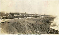 McCarthy Album 09, Photograph 006
 Caption: "Ocean Beach, San Francisco," c. 1925. Panorama of Ocean Beach, showing crowds not only at the beach but also at San Francisco's Playland, a series of seaside attractions and rides including a carousel, Fun House, and the Big Dipper rollercoaster. Entrepreneurs began erecting concessions and "thrill" rides at the location in the late nineteenth century. By 1913 the area was known as Chutes at the Beach. In 1923, brothers George and Leo Whitney began to purchase the attractions, eventually coming to own the entirety of what became known as Playland. The amusement park was torn down in 1972.
-
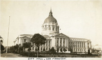 McCarthy Album 09, Photograph 005
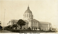
 Caption: "City Hall, San Francisco.," c. 1925. View of the Beaux Arts-style building that replaced San Francisco's City Hall after the original building was destroyed in the 1906 earthquake and fire. Designed by architect Arthur Brown, Jr., the building occupies two full city blocks. See also 96-07-08-alb09-003, 96-07-08-alb10-001, and 96-07-08-alb11-001.
-
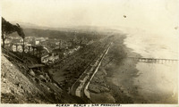 McCarthy Album 09, Photograph 004
 Caption: "Ocean Beach, San Francisco," c. 1925. Panorama of Ocean Beach, showing crowds not only at the beach but also at San Francisco's Playland, a series of seaside attractions and rides including a carousel, Fun House, and the Big Dipper rollercoaster. Entrepreneurs began erecting concessions and "thrill" rides at the location in the late nineteenth century. By 1913 the area was known as Chutes at the Beach. In 1923, brothers George and Leo Whitney began to purchase the attractions, eventually coming to own the entirety of what became known as Playland. The amusement park was torn down in 1972.
-
 McCarthy Album 09, Photograph 003
 Caption: "City Hall, San Francisco.," c. 1925. View of the Beaux Arts-style building that replaced San Francisco's City Hall after the original building was destroyed in the 1906 earthquake and fire. Designed by architect Arthur Brown, Jr., the building occupies two full city blocks. See also 96-07-08-alb09-005, 96-07-08-alb10-001, and 96-07-08-alb11-001.
-
 McCarthy Album 09, Photograph 002
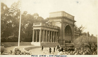
 Caption: "Music Stand, San Francisco." View of the Spreckels Temple of Music in San Francisco's Golden Gate Park, commonly known as the Music Stand or the Bandshell. The Temple was built in 1899-1900 at the west end of the park's Music Concourse. A gift to the City of San Francisco from sugar magnate Claus Spreckels, the Temple has been extensively renovated over the years to repair earthquake damage.
-
 McCarthy Album 09, Photograph 001
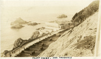
 Caption: "Cliff House, San Francisco," c. 1920. The building shown here is the fourth iteration of the Cliff House, a neo-classical design built after a fire destroyed the Victorian structure previously at the site in 1907. Reconstruction of the iconic restaurant began in 1908, and a new Cliff House opened in 1909 (the building in this photograph). The building was extensively remodeled in the 1930s.
-
 McCarthy Album 09, Photograph 000
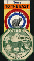
 Caption: "Tours to the East." Two National Park decals for Yellowstone Park (with handwritten date of Aug. 14, 23, featuring a bear) and Yosemite National Park in 1920 (with handwritten date of July 4, featuring a mountain lion).
-
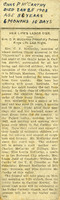 McCarthy Album 06, Photograph 303
 No Caption: An unidentified newspaper clipping of an obituary for the Mother of William McCarthy, Mrs. C.P. McCarthy. Hand written on the top of the page: "Chas P McCarthy Died Jan 25 1903, Age 56 years 6 Months 10 Days."
-
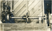 McCarthy Album 06, Photograph 302
 No caption. An unidentified piece of machinery at unidentified location.
-
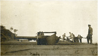 McCarthy Album 06, Photograph 301
 No caption. Several unidentified men and a piece of heavy artillery at an unidentified location.
-
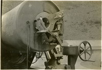 McCarthy Album 06, Photograph 300
 No caption. A close-up view of a piece of unidentified heavy artillery.
-
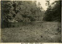 McCarthy Album 06, Photograph 299
 Caption: "Big Tree Grove - Santa Cruz," c. 1910.
-
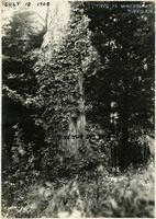 McCarthy Album 06, Photograph 298
 Caption: "The Yum Um Tree, This is Where it Began, July 12, 1908." A view of a large tree with a dense vine wrapped around its bark.
-
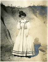 McCarthy Album 06, Photograph 297
 No caption. Grace McCarthy poses for photograph, wearing a man's hat, at an unidentified location, c. 1910.
-
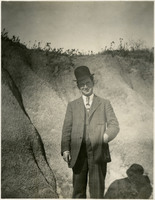 McCarthy Album 06, Photograph 296
 No caption. William McCarthy poses for a photograph at an unidentified location, c. 1910.
-
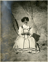 McCarthy Album 06, Photograph 295
 No caption. A smiling Grace McCarthy is seen sitting at the foot of a hillside, possibly a beach, c. 1910.
-
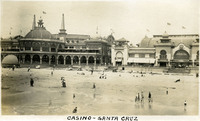 McCarthy Album 06, Photograph 294
 Caption: "Casino-Santa Cruz," c. 1910. A view of the beachside casino resort with many beachgoers enjoying the sand and water. The casino, designed by William Weeks, was constructed in 1907, replacing a previous casino building that burned down in 1906. See also 96-07-08-alb05-075.
-
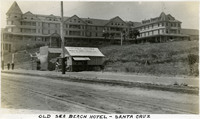 McCarthy Album 06, Photograph 293
 Caption: "Old Sea Beach Hotel - Santa Cruz," c. 1910. The Sea Beach Hotel, located on Beach Hill in Santa Cruz, was built in the 1870s by S.A. Hall. Originally called the Ocean View House, it was sold in the 1880s. Its new owner dubbed the building the Sea Beach Hotel. The resort hotel operated until burning down in 1912, never to be reconstructed.
-
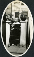 McCarthy Album 06, Photograph 292
 No caption. A portrait of an unidentified baby sitting in a high chair in an outdoor location, c. 1908.
-
 McCarthy Album 06, Photograph 291a
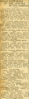
 No caption. An undated and unidentified newspaper article titled, "What Ships Make Up the Armada in the Harbor." c.1908. The article describes the forty-three battleships, cruisers, torpedo boats, torpedo boat destroyers, and auxiliary ships in the San Francisco Bay under the Flag of Rear Admiral Evans.
-
 McCarthy Album 06, Photograph 291
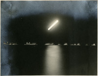
 No caption. A view of numerous and well-lit ships at night in the San Francisco Bay, during a visit by the Atlantic Fleet in 1908.
-
 McCarthy Album 06, Photograph 290
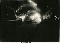
 Caption: "Fillmore St," c. 1908. A view of San Francisco's Fillmore Street at night, which has been decorated with garlands of electric lights along the length of the street.
-
 McCarthy Album 06, Photograph 289
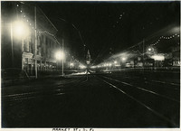
 Caption: "Market St, S.F," c. 1908. A view of San Francisco's Market Street at night. Electric lights are strung along the length of the street, ending at the Ferry Building, which is also decorated with electric lights.
-
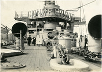 McCarthy Album 06, Photograph 288
 No caption. A view of the deck of the USS Connecticut, c. 1908. The Connecticut was commissioned on September 29, 1906 as the most advanced ship in the U.S. Navy. Because the provisions of the Washington Naval Treaty of 1922 stipulated that older battleships would be disposed of, the USS Connecticut was decommissioned and sold for scrap in 1923.
-
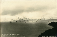 McCarthy Album 06, Photograph 287
 Inscribed on photograph: "The Arrival of the Atlantic Fleet at the Golden Gate - May 6, 1908. San Francisco, California. Copyright Charles Weidner, S.F." This photograph, by Charles Weidner, shows the U.S. Navy's Atlantic Fleet, consisting of sixteen battle cruisers and various support vessels, steaming toward the Golden Gate and San Francisco Bay. President Theodore Roosevelt ordered the Atlantic Fleet (later called the "Great White Fleet" because the ships were painted white with gold trim) on a tour around the world, beginning in December 1907, to show American goodwill and also demonstrate the power of the U.S. Navy. The Fleet reached the Golden Gate, entrance to San Francisco Bay, on May 6, 1908.
-
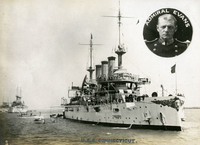 McCarthy Album 06, Photograph 286
 Caption: "USS Connecticut, Admiral Evans," c. 1908. View of the USS Connecticut, with an inset circular photograph of Admiral Evans. The USS Connecticut was commissioned on September 29, 1906 as the most advanced ship in the U.S. Navy. Because the provisions of the Washington Naval Treaty of 1922 stipulated that older battleships would be disposed of, the Connecticut was decommissioned and sold for scrap in 1923.
-
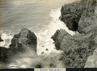 McCarthy Album 06, Photograph 285
 Caption: "Lands End S.F." Lands End is a rocky shoreline at the mouth of the Golden Gate in San Francisco. Today it is a park within the Golden Gate National Recreation Area
-
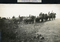 McCarthy Album 06, Photograph 284
 Caption: "Soldier Life," c. 1910. A view of soldiers on horseback, pulling heavy artillery up an embankment, at an unidentified location.