-
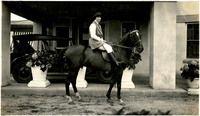 McCarthy Album 09, Photograph 177
 No caption. An unidentified woman seated on a horse saddled in English tack at the John Shields house in the Daybreak Estates area of Long Island.
-
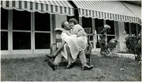 McCarthy Album 09, Photograph 176
 No caption. William and unidentified woman embrace while sitting in a wicker chair in front of the John Shields residence in the Daybreak Estate area of Long Island.
-
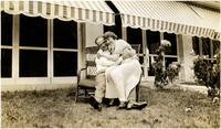 McCarthy Album 09, Photograph 175
 No caption. William McCarthy and unidentified woman embrace while sitting in a wicker chair in front of the John Shields residence in the Daybreak Estate area of Long Island.
-
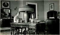 McCarthy Album 09, Photograph 174
 No caption: Grace McCarthy seated at a desk reading a book, in the guest room of a residence in the Daybreak Estate area of Long Island. See also 96-07-08-alb11-222.
-
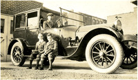 McCarthy Album 09, Photograph 173
 No caption. An unidentified man poses in the drivers seat of an automobile while two unidentified boys sit on the car's running boards.
-
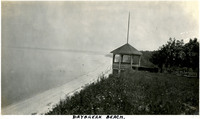 McCarthy Album 09, Photograph 172
 Caption: "Daybreak Beach." Beach scene in the Daybreak Estate area of Long Island. A gazebo stands at the edge of the cliff leading down to the beach.
-
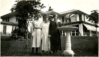 McCarthy Album 09, Photograph 171
 No caption: William (second from right) and Grace (far left) McCarthy pose with two unidentified people in front of the John Shields house in the Daybreak Estate area of Long Island.
-
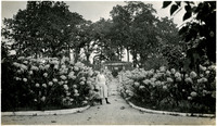 McCarthy Album 09, Photograph 170
 No caption. Grace McCarthy poses in a hydrangea garden, c. 1925. See also 96-07-08-alb09-160.
-
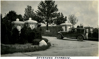 McCarthy Album 09, Photograph 169
 Caption: "Daybreak Entrance." A man pauses for a quick photo sitting in his car at the entrance to a private road leading to the Daybreak Estate area of Long Island.
-
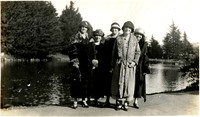
 McCarthy Album 09, Photograph 168
 No caption: William (middle) and Grace (far left) McCarthy posing with four unidentified women in front of a small body of water, c. 1925.
-
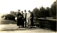
 McCarthy Album 09, Photograph 167
 No caption: Grace McCarthy (far left) poses with four unidentified women in front of a small body of water, c. 1925.
-
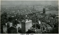
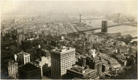 McCarthy Album 09, Photograph 166
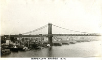
 No caption: Bird's eye view of New York City's Lower East Side and Two Bridges areas. The Brooklyn and Manhattan bridges span the East River in the right side of the photograph. See also 96-07-08-alb09-145.
-
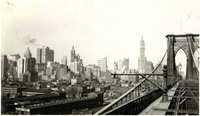 McCarthy Album 09, Photograph 165
 No caption: View of New York City's skyline, as seen from the Brooklyn Bridge, c. 1925. A portion of the bridge (designed by architect John Augustus Roebling and completed in 1883) can be seen in the right hand side of the photograph. See also 96-07-08-alb09-144.
-
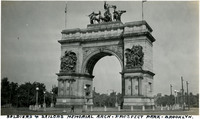 McCarthy Album 09, Photograph 164
 Caption: "Soldiers and Sailors Memorial Arch - Prospect Park - Brooklyn," c. 1925. (John H. Duncan, architect) The Soldiers' and Sailors' Arch was built between 1889 and 1892, and dedicated on October 21st, 1892 to honor the "Defenders of the Union, 1861-1865."
-
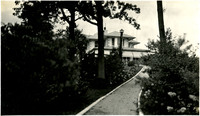 McCarthy Album 09, Photograph 163
 No caption: A path leading to the John Shields home on Long Island.
-
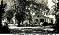 McCarthy Album 09, Photograph 162
 Caption: "Superintents [sic] Home On The J. Shields Home. Place. N.Y." A small home on the property of John Shields, on Long Island, secondary to the main residence on the property.
-
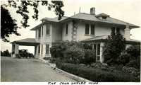 McCarthy Album 09, Photograph 161
 Caption: "The John Shields Home." Side view of the residence of John Shields on Long Island, with a car parked under a carport.
-
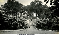 McCarthy Album 09, Photograph 160
 Caption: "Hydrangia [sic]Pathway." Grace McCarthy poses in a hydrangea garden. See also 96-07-08-alb09-170.
-
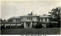 McCarthy Album 09, Photograph 159
 Caption: "The John Shields Home. N.Y." Residence of John Shields, on Long Island in the Daybreak Estate area. See also 96-07-08-alb11-221.
-
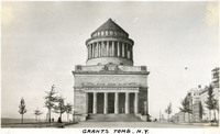 McCarthy Album 09, Photograph 158
 Caption: "Grants Tomb. N.Y." The remains of Ulysses S. Grant, 18th President of the U.S. and Commanding General of the Union Army during the last year of the Civil War, were laid to rest in this elaborate tomb, designed by architect John Duncan. Grant died in 1885, but construction on the granite and marble structure did not begin until 1891. Grant's remains were transferred to the tomb on April 27, 1897. The tomb is the largest mausoleum in North America. See also 96-07-08-alb11-209.
-
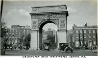 McCarthy Album 09, Photograph 157
 Caption: "Washington Arch - Washington Square. N.Y," c. 1925. The marble Washington Square Arch (Stanford White, architect) was built between 1890 and 1892 to replace the original wooden arch, which had been erected in 1889 to honor the centennial of President George Washington's inauguration.
-
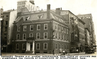 McCarthy Album 09, Photograph 156
 Caption: "Frances [sic] Tavern N.Y. Where Washington Took Leave Of Offices And Disbanded The Troops At Conclusion Of Revolutionery [sic] War." Built as a family home for Etienne "Stephen" DeLancey in 1719, this building was converted to use as a tavern in 1762. It served many important functions before, during, and after the Revolutionary War, but several fires in the nineteenth century erased the building's original appearance. The Sons of the Revolution purchased the property in 1904 and embarked upon extensive restoration plans in 1907, supervised by William Mersereau. The building is now used as a museum and art gallery. See also 96-07-08-alb11-203.
-
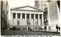 McCarthy Album 09, Photograph 155
 Caption: "Subtreasury - Wall Street - Washington Statue Marking Spot Where Washington Took His Oath of Office April 30 1789." The original building on this site, constructed in 1700, served as New York's city hall, then as the Capitol for the newly-created United States under the Constitution of 1789, and was the site of George Washington's inauguration as the first U.S. President. The original building was demolished in 1812, but a new building, designed to house the U.S. Custom House for the Port of New York, was opened in 1842. It is this building that is seen in the photograph. The new building subsequently housed one of six U.S. sub-treasuries between 1862 and 1920. A statue of George Washington (John Quincy Adams Ward, sculptor) was erected in front of the building in 1882, to commemorate the approximate site of Washington's inauguration. See also 96-07-08-alb11-204.
-
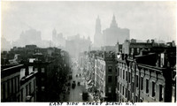 McCarthy Album 09, Photograph 154
 Caption: "East Side Street Scene. N.Y," c. 1925. Bird's eye view of a street in New York City's East Side. The city's skyline looms in the background.
-
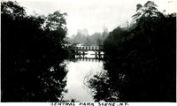 McCarthy Album 09, Photograph 153
 Caption: "Central Park Scene N.Y.," c. 1925. New York City's Central Park, established in 1857, was designed by landscape architect Frederick Law Olmsted and landscape designer and architect Calvert Vaux. This photograph shows one of the water features within the park, crossed by a pedestrian bridge.
-
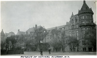 McCarthy Album 09, Photograph 152
 Caption: "Museum of Natural History N.Y.," c. 1925. View of the original building of the American Museum of Natural History in New York City. The Victorian Gothic-style building, often referred to as a "castle," was designed by J. Wrey Mould. It opened in 1877. Later expansions added to the complex around this building and have disguised much of it from view.
-
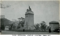 McCarthy Album 09, Photograph 151
 Caption: "Main [sic] Memorial Statue - Central Park N. Y." c. 1925. The monument was designed by Harold Van Buren Magonile, while the statuary was created by Attilio Piccirilli. The memorial, dedicated in New York City's Central Park in 1913, honors the more than 260 men killed aboard the USS Maine when the ship exploded in Havana's harbor during the Spanish-American War in 1898.
-
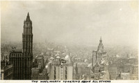 McCarthy Album 09, Photograph 150
 Caption: "The Woolworth Towering Above All Others," c. 1925. Constructed between 1910 and 1920 and designed by architect Cass Gilbert, the Neo-Gothic building was once the tallest in the world at 792 feet. It appears at the left side of this photograph.
-
 McCarthy Album 09, Photograph 149
 Caption: "Brooklyn Bridge N.Y.," c. 1925. Erroneously labeled, this photograph actually shows the Manhattan Bridge spanning the East River, just west of the Brooklyn Bridge. The Manhattan Bridge, designed by Leon Moisseiff, opened in 1909.
-
 McCarthy Album 09, Photograph 148
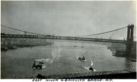
 Caption: "East River & Brooklyn Bridge N.Y," c. 1925. Three boats on the East River passing beneath the Manhattan Bridge. The photograph was taken from the Brooklyn Bridge (which is not seen in the photo). See also 96-07-08-alb09-199.
-
 McCarthy Album 09, Photograph 147
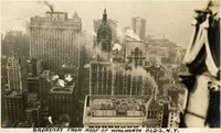
 Caption: "Broadyay [sic] from Roof of Woolworth Bldg N.Y.," c. 1925. Bird's eye view of New York City's Broadway, and surrounding skyscrapers.
-
 McCarthy Album 09, Photograph 146
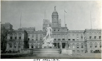
 Caption: "City Hall - N.Y," c. 1925. View of the façade of New York City's City Hall. The French Renaissance style building, designed by architect John McComb, Jr., was constructed between 1803 and 1811. The statue Civic Virtue Triumphant Over Unrighteousness (Frederick William MacMonnies, sculptor) stands in front of the building. The statue, unveiled in 1922, has subsequently been moved. It now stands in Brooklyn's Green-Wood Cemetery.
-
 McCarthy Album 09, Photograph 145
 Caption: "East Side New York." Bird's eye view of New York City's Lower East Side and Two Bridges areas. The Brooklyn and Manhattan bridges span the East River in the right side of the photograph. See also 96-07-08-alb09-166.
-
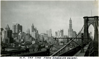 McCarthy Album 09, Photograph 144
 Caption: "N.Y. Sky Line From Brooklyn Bridge." View of New York City's skyline, as seen from the Brooklyn Bridge. A portion of the bridge (designed by architect John Augustus Roebling and completed in 1883) can be seen in the right hand side of the photograph. See also 96-07-08-alb09-165.
-
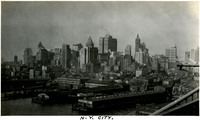 McCarthy Album 09, Photograph 143
 Caption: "N.Y. City." View of Manhattan's skyline as viewed from the Brooklyn Bridge in 1934. See also 96-07-08-alb11-205.
-
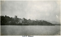 McCarthy Album 09, Photograph 142
 Caption: "West Point," c. 1925. The United States Military Academy, commonly referred to as West Point, as viewed from across the Hudson River.
-
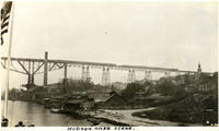 McCarthy Album 09, Photograph 141
 Caption: "Hudson River," c. 1925. A train crosses high above the Hudson River over the Poughkeepsie-Highland Railroad Bridge. Buildings of the C.N. Arnold Co., a lumber company, sit on the bank of the river in the foreground. The Poughkeepsie-Highland Railroad Bridge first began operation in 1889. The tracks were destroyed by a fire in 1974, but the bridge was subsequently rebuilt, opening as the Walkway Over the Hudson (a pedestrian bridge) in 2003.
-
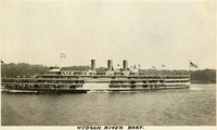 McCarthy Album 09, Photograph 140
 Caption: "Hudson River Boat," c. 1925. The Washington Irving, a three-stack steamer ship, is shown in this photograph. The ship was in operation from 1913 to 1926, when it collided with an oil barge and sank.
-
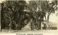 McCarthy Album 09, Photograph 139
 Caption: "Watervliet Arsenal Entrance," c. 1925. A tree-lined driveway to the Watervliet Arsenal Entrance. The Arsenal was founded in 1813 in Watervliet, New York, to support the War of 1812. Today the Arsenal houses the U.S. Army's Benét Laboratories, part of the Army's Armament Research, Development and Engineering Center.
-
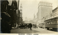 McCarthy Album 09, Photograph 138
 Caption: "Albany Street Scene," c. 1925. A street in Albany, lined with cars and trollies.
-
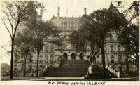 McCarthy Album 09, Photograph 137
 Caption: "N.Y. State Capitol - Albany." New York State's Capitol Building was constructed between 1867 and 1899. The initial architect, Thomas Fuller, designed the first floor in a Classical or Romanesque style. He was replaced by Leopold Eidlitz and Henry Hobson Richardson, who designed the next two floors in a Renaissance style. The final architect to preside over the project, Isaac G. Perry, completed the building in a Victorian-Romanesque style. See also 96-07-08-alb11-247.
-
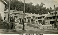 McCarthy Album 09, Photograph 136
 Caption: "Court Cottages - Montreal," c. 1925. View of several connected, multi-story apartments in Montreal.
-
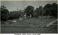 McCarthy Album 09, Photograph 135
 Caption: "Rangers Home - Mount Royal Park," c. 1930. The Smith House, seen in this photograph surrounded by trees and a beautifully manicured flower garden, is a residence in Montreal's Mount Royal Park. Built in 1858 and purchased by the city when the ground was bought for the park's creation, the Smith House has been used for a variety of functions. It currently houses an interpretive center for the park as well as operating as the headquarters for Les amis de la montagne (The Friends of the Mountain), a nonprofit organization dedicated to preserving the environment of Mount Royal.
-
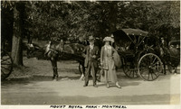 McCarthy Album 09, Photograph 134
 Caption: "Mount Royal Park - Montreal," c. 1925. William and Grace McCarthy pose in front of a horse and buggy at Montreal's Mount Royal Park.
-
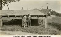 McCarthy Album 09, Photograph 133
 Caption: "Toboggan Slide - Mount Royal Park - Montreal," c. 1925. William and Grace McCarthy pose in front of a large toboggan slide, absent of snow, at Montreal's Mount Royal Park.
-
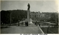 McCarthy Album 09, Photograph 132
 Caption: "St. Josephs Oratore [sic] - Montreal," c. 1925. William and Grace McCarthy pose in front of a bronze statue of St. Joseph placed at the base of the hill upon which St. Joseph's Oratory is under construction. The statue, created by Alfred Laliberté, was erected in 1923.
-
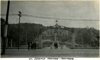 McCarthy Album 09, Photograph 131
 Caption: "St. Josephs Oratore [sic] - Montreal," c. 1925. William and Grace McCarthy beneath the entry arch to the complex containing St. Joseph's Oratory, a Roman Catholic basilica and shrine. Work on the building began in 1924, and continued until 1967. Only the first level of the building had been completed when this photograph was taken.
-
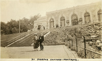 McCarthy Album 09, Photograph 130
 Caption: "St. Josephs Oratore [sic] - Montreal.," c. 1925. Unidentified man and Grace McCarthy pose in front of the St. Joseph's Oratory in Montreal, a Roman Catholic basilica and shrine. Work on the building began in 1924, and continued until 1967. Only the first level of the building had been completed when this photograph was taken.
-
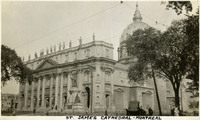 McCarthy Album 09, Photograph 129
 Caption: "St. James Cathedral - Montreal," c. 1925. The St. James Cathedral in Montreal was consecrated in 1894. At that time, it was the largest church in Quebec. Pope Pious XII rededicated the church in 1955 to Mary, Queen of the World. See also 96-07-08-alb04-092.
-
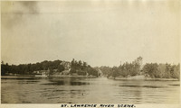 McCarthy Album 09, Photograph 128
 Caption: "St. Lawrence River Scene," c. 1925. This photograph looks across the Saint Lawrence River toward two large houses on the far bank. One of the houses may be on a small island.