-
 McCarthy Album 07, Photograph 003
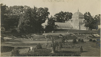
 Caption: "Conservatory Golden Gate Park," c. 1910. See also 96-07-08-alb03-006, and 96-07-08-alb02-014. The Conservatory of Flowers in Golden Gate Park, San Francisco, originally opened in 1879. After the most recent extensive rehabilitation, the conservatory reopened in 2003 and is a city, state, and national historic landmark.
-
 McCarthy Album 07, Photograph 002
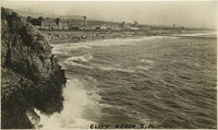
 Caption: "Cliff Beach." Shows views of Ocean Beach near the Cliff House in San Francisco, c. 1910.
-
 McCarthy Album 07, Photograph 001
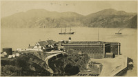
 Caption: "Fort Point." c. 1906. See also 96-07-08-alb06-009 with caption: "Fort Point and Golden Gate," and 96-07-08-alb03-118, San Francisco. Fort Point in the foreground, with ships in the bay. Fort Point was part of an effort by the U.S. government to protect the Golden Gate, entrance to the San Francisco Bay. Built between 1853-1861 of brick and mortar, the fort included emplacements for 141 guns but never fired a weapon in defense of the Bay.
-
 McCarthy Album 09, Photograph 321b
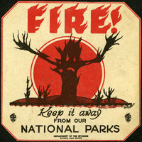
 This warning sticker advertises "FIRE! Keep it away form our National Parks." The silhouette of a skeletal tree stretches bare branches toward the viewer.
-
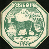 McCarthy Album 09, Photograph 321a
 A green and white decal commemorating a visit to Yosemite National Park in 1928, featuring a mountain lion against a stylized sketch of Half Dome.
-
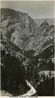
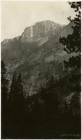 McCarthy Album 09, Photograph 321
 No Caption. Mountain scene at Yosemite National Park, c. 1917.
-
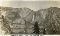 McCarthy Album 09, Photograph 320
 Caption: "Yosemite Falls - View From Glacier Point," c. 1917. Yosemite Falls in the distance, as seen from Glacier Point. The highest waterfall in Yosemite National Park, Yosemite Falls is made up of two successive cascades falling a total of 2,425 feet from the top of the Upper Fall to the base of the Lower Fall. The Upper Fall alone is 1,430 feet high, and is one of the top twenty highest waterfalls in the world.
-
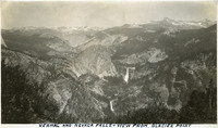 McCarthy Album 09, Photograph 319
 Caption: "Vernal and Nevada Falls - View From Glacier Point," c. 1917. Example of the spectacular views available from Glacier Point on the south wall of the Yosemite Valley. Vernal and Nevada Falls can be seen in the distance.
-
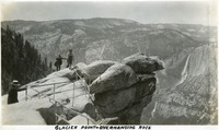 McCarthy Album 09, Photograph 318
 Caption: "Glacier Point - Overhanging Rock," c. 1935. Grace McCarthy poses for a photograph at Glacier Point's iconic overhanging rock. Glacier Point, on the south wall of the valley 3,200 feet above what is now known as Half Dome Village, provides panoramic views of the valley and many of its features. By the time this photograph was taken, safety railings had been installed at the Point to prevent visitors from tumbling over the cliff while trying to get the best views.
-
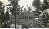 McCarthy Album 09, Photograph 317
 Caption: "Glacier Point Hotel," c. 1917. The 80-room chalet-style Glacier Point Hotel opened in 1918, located 3,218 feet above the floor of Yosemite Valley on Glacier Point. This photograph shows the back side of the building, with a viewing porch that looked out over the valley. The building was destroyed by an electrical fire in July 1969.
-
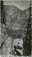 McCarthy Album 09, Photograph 316
 Caption: "Yosemite Falls - View From Ledge Trail," c. 1917. Yosemite Falls in the distance, as seen from across the valley on the Ledge Trail above Half Dome Village. The highest waterfall in Yosemite National Park, Yosemite Falls is made up of two successive cascades falling a total of 2,425 feet from the top of the Upper Fall to the base of the Lower Fall. The Upper Fall alone is 1,430 feet high, and is one of the top twenty highest waterfalls in the world.
-
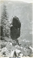 McCarthy Album 09, Photograph 315
 Caption: "Balance Rock," c. 1917. Grace McCarthy poses in front a massive boulder balanced on its tip, appearing ready to fall over at any moment.
-
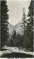
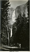
 McCarthy Album 09, Photograph 314
 Caption: "Bridal Veil Falls [sic]," c. 2017. The 617-foot-tall Bridalveil Fall, one of the iconic natural wonders of Yosemite National Park.
-
 McCarthy Album 09, Photograph 313
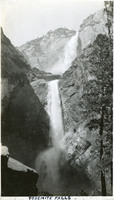
 Caption: "Yosemite Falls," c. 1917. Both Upper and Lower Yosemite Falls can be seen in this photograph, taken at a location near the base of Lower Yosemite Fall. The highest waterfall in Yosemite National Park, it is made up of two successive cascades falling a total of 2,425 feet from the top of the Upper Fall to the base of the Lower Fall. The Upper Fall alone is 1,430 feet high, and is one of the top twenty highest waterfalls in the world.
-
 McCarthy Album 09, Photograph 312
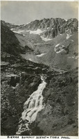
 Caption: "Sierra Summit Scene - Tioga Pass," c. 1917. Patches of snow litter the walls of Tioga Pass, while a small stream cascades down the hillside. California State Route 120 runs through the pass, providing an eastern entry into Yosemite National Park.
-
 McCarthy Album 09, Photograph 311
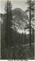
 Caption: "Scene On The Tioga Road," c. 1917. In a photograph taken from the Tioga Road, a massive granite dome rises above the trees in Yosemite National Park.
-
 McCarthy Album 09, Photograph 310
 Caption: "Bridal Veil [sic] Falls," c. 1917. A road winds through trees while Bridalveil Fall cascades down the south wall of Yosemite Valley in the distance.
-
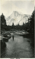 McCarthy Album 09, Photograph 309
 Caption: "Half Dome," c. 1917. The Merced River flows through the photograph in the foreground, while the iconic Half Dome looms in the background.
-
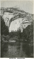 McCarthy Album 09, Photograph 308
 Caption: "Granite Formation," c. 1917. A granite wall towers above the Merced River in this photograph of a portion of the Yosemite Valley.
-
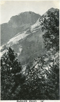 McCarthy Album 09, Photograph 307
 Caption: "Glacier Point (x)," c. 1917. In this photograph of the walls of Yosemite Valley, taken from the valley floor, William McCarthy has marked the location of Glacier Point with an "x." Glacier Point, on the south wall of the valley 3,200 feet above what is now known as Half Dome Village, provides panoramic views of the valley and many of its features.
-
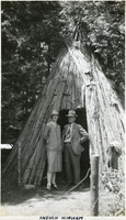 McCarthy Album 09, Photograph 306
 Caption: "Indian Wigwam," c. 1935. William and Grace McCarthy pose at the entrance to what William labeled a "wigwam," a dwelling of the Ahwahnechee people. The Ahwahnechee (a Native American tribe who traditionally occupied the Yosemite Valley) called the dwellings o-chum. Pine branches were arranged in a tee-pee-like shape and then covered with layered slabs of cedar bark.
-
 McCarthy Album 09, Photograph 305
 Caption: "Sunrise - Mirror Lake - Yosemite," c. 1917. A reflection of a sunrise on Mirror Lake. The lake, fed by Tenaya Creek, is the remains of a glacial lake that used to fill most of the valley. Its calm waters provide near-perfect reflections of the surrounding natural splendor.
-
 McCarthy Album 09, Photograph 304
 Caption: "Cascade Falls," c. 1917. Erroneously labeled as Cascade Falls, this photograph actually shows both the Upper and Lower Yosemite Falls as viewed from the floor of Yosemite Valley. The highest waterfall in Yosemite National Park, Yosemite Falls is made up of two successive cascades falling a total of 2,425 feet from the top of the Upper Fall to the base of the Lower Fall. The Upper Fall alone is 1,430 feet high, and is one of the top twenty highest waterfalls in the world.
-
 McCarthy Album 09, Photograph 303
 Caption: "Lilouette [sic] Falls," c. 1917. Illilouette Falls is a 370-foot waterfall in Yosemite located on the Illilouette Creek, a small tributary of the Merced River. The photograph was taken from a point above the summit of the falls.
-
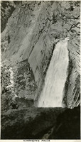
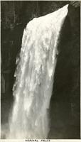 McCarthy Album 09, Photograph 302
 Caption: "Vernal Falls [sic]," c. 1917. Closeup view of Vernal Fall, a 317-foot waterfall on the Merced River, downstream of Nevada Fall.
-
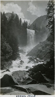 McCarthy Album 09, Photograph 301
 Caption: "Vernal Falls [sic]," c. 1917. The Merced River tumbles over boulders downstream of the 317-foot tall cascade of Vernal Fall.
-
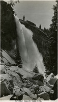 McCarthy Album 09, Photograph 300
 Caption: "Nevada Falls [sic] - Yosemite," c. 1917. Nevada Fall is a 594-foot high waterfall upstream of Vernal Fall on the Merced River, in the Little Yosemite Valley. This photograph, taken at a point next to the fall's path of descent, shows the upper portion of the fall.
-
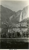
 McCarthy Album 09, Photograph 299
 Caption: "Yosemite Falls," c. 1917. Grace McCarthy two unidentified friends pose for a photograph on the trail to Yosemite Falls. Both Upper and Lower Fall can be seen in this photograph. The highest waterfall in Yosemite National Park, Yosemite Falls is made up of two successive cascades falling a total of 2,425 feet from the top of the Upper Fall to the base of the Lower Fall. The Upper Fall alone is 1,430 feet high, and is one of the top twenty highest waterfalls in the world.
-
 McCarthy Album 09, Photograph 298
 Caption: "Mountain Scene - Yosemite," c. 1917. Granite cliffs and evergreen trees dominate this photograph.
-
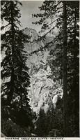 McCarthy Album 09, Photograph 297
 Caption: "Towering Trees and Cliffs - Yosemite," c. 1917. View of a granite mountain top as viewed through trees on a neighboring peak.
-
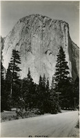 McCarthy Album 09, Photograph 296
 Caption: "El Capitan," c. 1917. El Capitan is a vertical granite rock formation in Yosemite Valley. It's sheer cliff face, rising almost 3,000 feet above the Valley, is a favorite rock climbing location.
-
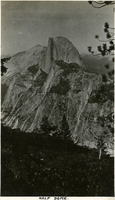 McCarthy Album 09, Photograph 295
 Caption: "Half Dome," c. 1917. The iconic granite Half Dome rises above the Yosemite Valley in this photograph, taken from a neighboring peak.
-
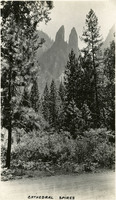 McCarthy Album 09, Photograph 294
 Caption: "Cathedral Spires," c. 1917. Rock formation known as Cathedral Spires in Yosemite National Park, as seen from the valley floor through trees.
-
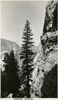 McCarthy Album 09, Photograph 293
 Caption: " Rugged Cliffs," c. 1917. View of a sheer cliff face with rocky, timbered mountains beyond.
-
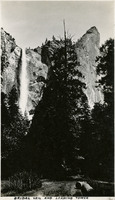 McCarthy Album 09, Photograph 292
 Caption: "Bridal Veil [sic] and Leaning Tower," c. 1917. Bridalveil Fall and the adjacent Leaning Tower, a popular rock climbing destination within Yosemite National Park.
-
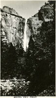 McCarthy Album 09, Photograph 291
 Caption: "Bridal Veil Falls [sic]," c. 2017. The 617-foot-tall Bridalveil Fall, one of the iconic natural wonders of Yosemite National Park.
-
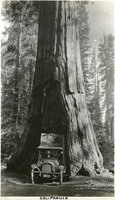 McCarthy Album 09, Photograph 290
 Caption: "California," c, 1917. The McCarthy's vehicle is squeezed into the tunnel carved through the California Tree, a Giant Sequoia in the Mariposa Grove of Yosemite National Park. The tunnel was cut through the tree in 1895 to facilitate travel on the road into the grove, and also as a tourist attraction. It is now the only living Giant Sequoia with a tunnel cut through it (so-called "tunnel trees"), the others having all fallen.
-
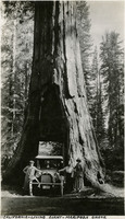 McCarthy Album 09, Photograph 289
 Caption: "California - Living Giant - Mariposa Grove," c. 1917. William and Grace McCarthy, with an unidentified friend, pose with their vehicle in the tunnel through the California Tree, a Giant Sequoia in the Mariposa Grove of Yosemite National Park. The tunnel was cut through the tree in 1895 to facilitate travel on the road into the grove, and also as a tourist attraction. It is now the only living Giant Sequoia with a tunnel cut through it (so-called "tunnel trees"), the others having all fallen.
-
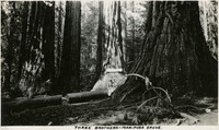 McCarthy Album 09, Photograph 288
 Caption: "Three Brothers - Mariposa Grove," c. 1917. Two unidentified people pose in the Mariposa Grove next to three Giant Sequoias.
-
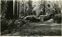 McCarthy Album 09, Photograph 287
 Caption: "Fallen Giant - Mariposa Grove," c. 1917. Grace McCarthy poses with two unidentified people next to the Fallen Monarch, the enormous trunk of a fallen Giant Sequoia in Maripose Grove. It is estimated that the tree fell more than 300 years ago, but the natural resistance of Giant Sequoias to rot has preserved the trunk to the present time.
-
 McCarthy Album 09, Photograph 286
 Caption: "Entrance - Mariposa Grove- Yosemite," c. 1917. Grace McCarthy stands with an automobile near the entrance to Maripose Grove in Yosemite National Park. The Mariposa Grove, near Wawona, is the largest grove of Giant Sequoia trees in Yellowstone National Park. It also includes two of the thirty largest Giant Sequoias in the world.
-
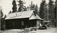 McCarthy Album 09, Photograph 285
 Caption: "Forest Ranger Station," c. 1917. Grace McCarthy (in the driver's seat of the automobile) and an unidentified man taking a break from driving by pausing next to a small plank house, identified as a forest ranger station by William McCarthy.
-
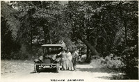
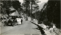 McCarthy Album 09, Photograph 284
 Caption: "Yosemite Driveways," c. 1917. Grace McCarthy and two unidentified people pose next to a vehicle on a dirt road in Yosemite National Park.
-
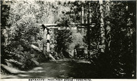
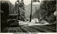 McCarthy Album 09, Photograph 283
 Caption: "Yosemite - El Portal Highway," c. 1917. Grace McCarthy and an unidentified man and woman sit at the side of the El Portal Road, now California State Route 140. Their automobile is parked across the road, and timbered, granite mountainsides provide the background.
-
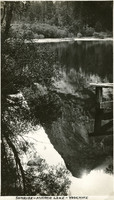
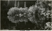 McCarthy Album 09, Photograph 282
 Caption: "Mirror Lake," c. 1917. Mirror Lake in Yosemite National Park, on Tenaya Creek, is the remains of a glacial lake that used to fill most of the valley. Its calm waters provide near-perfect reflections of the surrounding natural splendor.
-
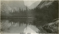 McCarthy Album 09, Photograph 281
 Caption: "Mirror Lake," c. 1917. Mirror Lake in Yosemite National Park, on Tenaya Creek, is the remains of a glacial lake that used to fill most of the valley. Its calm waters provide near-perfect reflections of the surrounding natural splendor.
-
 McCarthy Album 09, Photograph 280
 Caption: "Yosemite Driveways," c. 1917. William (right) and Grace (left, near vehicle) McCarthy pose with an unidentified woman next to an automobile on a dirt road in Yosemite National Park.
-
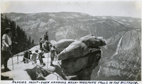 McCarthy Album 09, Photograph 279
 Caption: "Glacier Point - Over Hanging Rock - Yosemite Falls In The Distance," c. 1935. A group of unidentified people looking out from Glacier Point. Both Upper and Lower Yosemite Fall are visible across the valley at the right side of the photograph. Glacier Point, on the south wall of the valley 3,200 feet above what is now known as Half Dome Village, provides panoramic views of the valley and many of its features. By the time this photograph was taken, safety railings had been installed at the Point to prevent visitors from tumbling over the cliff while trying to get the best views.
-
 McCarthy Album 09, Photograph 278
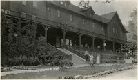
 Caption: "El Portal," c. 1917. Grace McCarthy poses with two unidentified people in front of the Hotel del Portal (or Del Portal Hotel) in El Portal, California. The resort hotel was constructed in 1908 by the Yosemite Terminal Company, a subsidiary of the Yosemite Valley Railroad Company, to provide accommodations for visitors to the park who arrived by train. The hotel burned to the ground in late October of 1917.
-
 McCarthy Album 09, Photograph 277
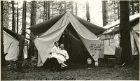
 Caption: "Life At Camp Curry," c. 1917. Two unidentified people pose in front of their tent at Camp Curry. An arrow points to an enameled pail just inside the tent, labeled "For Use in Case of Fire." Yosemite's Half Dome Village, established by David and Jennie Curry in 1899, was originally called Camp Curry, and then later Curry Village. It was designed to provide cheaper accommodations for Yosemite tourists than the resort hotels. The couple set up furnished tents and provided amenities such as a dining tent. As attendance at the park increased, the couple constructed more facilities with more modern amenities. In 2016, as a result of a legal dispute over trademarked names in the park, Curry Village changed its name to Half Dome Village.