-
 McCarthy Album 11, Photograph 077
 Caption: "In Memory of Florida Confederates, Memorial Monument -- Pensacola Florida, June 21, 34." Photograph of the pillar and statue erected in Pensacola's Lee Square in 1891, memorializing "the Uncrowned Heroes of the Southern Confederacy" and Confederate leaders such as Jefferson Davis. Two low pyramids made up of cannon balls bracket the monument. As of the time of this writing (November 2017), controversy swirls around efforts to remove the memorial.
-
 McCarthy Album 11, Photograph 076
 Caption: "Oklahawaha [sic] River at Silver Springs -- Florida, June 24, 34." View of a placid Ocklawaha River flowing by a lush park on the bank opposite the photographer.
-
 McCarthy Album 11, Photograph 075
 Caption: "Silver Springs -- Florida, June 24, 1934." Grace McCarthy seated in a gazebo with a conical roof sheathed in grass or brush. Silver Springs, a series of artesian springs in Marion County, was Florida's first tourist attraction. The area began to attract visitors after the Civil War, in the late 1860s. In the late 1870s, entrepreneurs started offering glass-bottom boat tours of the springs. The locale became popular in the 1930s with film producers: several of the original Tarzan movies were filmed here, as was the Creature from the Black Lagoon (1954).
-
 McCarthy Album 11, Photograph 074
 Caption: "Sugar Cane and Cotton Fields -- Florida, June 23, 34." A sugar cane field (at left) borders a cotton field (at right) in this photograph.
-
 McCarthy Album 11, Photograph 073
 Caption: "Suwannee River -- Florida, June 23, 1934." William and Grace McCarthy posing beneath a sign reading "'Way Down Upon The Suwannee River', Stephen Foster," referring to the minstrel song written by Foster in 1851. The Suwannee River flows by in the background.
-
 McCarthy Album 11, Photograph 072
 Caption: "Monroe St. Tallahassee -- Florida, June 23 1934." Street scene, showing Tallahassee's Monroe Street. Trees and residences line the roadway, with Spanish moss dripping from some of the trees.
-
 McCarthy Album 11, Photograph 071
 Caption: "State Capitol Tallahassee, Florida, June 23, 1934." View of the Florida State Capitol building, constructed in 1845. The dome, visible in the center of the photograph, was added in 1902. The building was altered and expanded several more times over the years, until a new State Capitol was built in the late 1970s. The old Capitol building was subsequently restored to its 1902 appearance and reopened to the public in 1982.
-
 McCarthy Album 11, Photograph 070
 Caption: "Mrs Eliza Smarts Home and Kin -- Chattahoochee, Florida, June 22, 34." Eliza Smart (standing, on the left), two unidentified women, and nine children posing on the porch of a house with wood siding. This is one of the few photographs in which the McCarthys identified some of the people who they met along their travels.
-
 McCarthy Album 11, Photograph 069
 Caption: "Mrs Eliza Smart and Family -- Chattahoochee, Florida, June 22, 34." Eliza Smart (standing in the back) and nine unidentified children, posing under a tree for the photograph. This is one of the few photographs in which the McCarthys identified the people who they met along their travels.
-
 McCarthy Album 11, Photograph 068
 Caption: "Florida Highway, June 21 34." A tree-lined, unidentified highway stretches into the distance in this photograph.
-
 McCarthy Album 11, Photograph 067
 Caption: "Palofax [sic] St. Pensacola, Florida, June 21, 34." Street scene on Palafox Street in Pensacola. In the foreground the street is lined with trees, while a city center is visible in the distance.
-
 McCarthy Album 11, Photograph 066
 Caption: "Mobile Bay, Mobile, Alabama, June 21, 34." The photograph provides a view of Mobile Bay, an inlet of the Gulf of Mexico in Alabama. The City of Mobile sits at its northwestern shore. Harbor facilities are evident in the photograph, and several small boats are docked at a wharf, including the tugboat Harry G. Lytle.
-
 McCarthy Album 11, Photograph 065
 Caption: "Great Southern Hotel -- Gulfport -- Mississippi -- June 19, 34." The Great Southern Hotel, built in 1902-1903 by entrepreneur Joseph T. Jones (also the founder of Gulfport), offered luxurious amenities such as telephones in each room, baths, hot and cold running water, billiards, gardens, and a tennis court. The hotel was hit hard by the Great Depression in the 1930s, even closing briefly. After a short-lived revival in the 1940s, the hotel was demolished in 1951 to make way for U.S. Highway 90.
-
 McCarthy Album 11, Photograph 064
 Caption: "Mothers War Memorial, Gulfport, Mississippi, June 19, 34." A columned memorial is visible at the left side of this photograph of Gulfport, Mississippi. Two multi-story buildings stand at the right.
-
 McCarthy Album 11, Photograph 063
 Caption: "Causeway Crossing Lake Pontchartrain -- New Orleans -- June 19, 34." The concrete deck of the Maestri Bridge (also called the Pontchartrain Bridge, the Five Mile Bridge, or the Watson-Williams Pontchartrain Bridge) stretches into the distance over Lake Pontchartrain in this photograph. Built in 1928 as the first permanent crossing of Lake Pontchartrain, it was also the longest concrete bridge in the world at the time of its construction. The bridge, almost five miles long, spans the lake between New Orleans and Slidell, Louisiana.
-
 McCarthy Album 11, Photograph 062
 Unidentified African-American woman, several children, and a dog posing on and around the porch of a wood-plank home. *Please Note:* Original caption removed due to sensitive content. To view the original photograph with caption, please contact the California State Archives Reference Desk.
-
 McCarthy Album 11, Photograph 061
 Unidentified African-American woman and several children posing on the porch of a wood-plank home. *Please Note:* Original caption removed due to sensitive content. To view the original photograph with caption, please contact the California State Archives Reference Desk.
-
 McCarthy Album 11, Photograph 060
 Unidentified African-American woman and several children posing on the porch of a wood-plank home. *Please Note:* Original caption removed due to sensitive content. To view the original photograph with caption, please contact the California State Archives Reference Desk.
-
 McCarthy Album 11, Photograph 059
 Unidentified African-American woman, several children, and a dog, posing on and around the porch of a wood-plank home. *Please note:* Original caption removed due to sensitive content. To view the original photograph with caption, please contact the California State Archives Reference Desk.
-
 McCarthy Album 11, Photograph 058
 Caption: "Home of Mary Clark -- Movie Star -- New Orleans, June 17, 1934." View of large, two-story residence in New Orleans. William McCarthy described this as the home of Helen Marguerite Clark, a silent film actress who married Louisiana businessman Harry Palmerston Williams. California State Archives staff were not able to confirm that this house was one of the New Orleans-area residences owned by the couple.
-
 McCarthy Album 11, Photograph 057
 Caption: "City Parkway -- New Orleans. June 16, 34." A row of palm trees interspersed with deciduous trees runs down the middle of this road in New Orleans.
-
 McCarthy Album 11, Photograph 056
 Caption: "Unloading Bananas from Steamer at New Orleans, June 16 34." Conveyor belt, and workers unloading bunches of bananas from a cargo ship.
-
 McCarthy Album 11, Photograph 055
 Caption: "First Apt. House in America -- New Orleans -- Jun 16, 34." One of the Pontalba Buildings occupies the right side of this photograph. These large, matching, red brick buildings, constructed in the late 1840s by Baroness Micaela Almonester Pontalba, form two sides of Jackson Square in New Orleans' French Quarter. Popular belief holds that these are the oldest continuously-rented apartment buildings in the U.S. However, that assertion has been challenged by historians who state that the buildings served as row houses for almost a century, not functioning as apartment buildings until the 1930s.
-
 McCarthy Album 11, Photograph 054
 Caption: "Cabildo or Old Spanish Jail and St. Louis Cathedral -- New Orleans, June 16, 34." The façade of the Cabildo dominates this photograph, while the corner of St. Louis Cathedral is visible at the right. The Cabildo was the seat of government for New Orleans while the area was under Spanish jurisdiction. The building was also the site of the transfer ceremonies when the U.S. purchased the Louisiana Territory from France in 1803. Although damaged by fire in 1988, the restored Cabildo survived Hurricane Katrina in 2005 with only minor damage.
-
 McCarthy Album 11, Photograph 053
 Caption: "New Orleans Iron Fence Made to Represent Corn. June 16, 34." The iron pickets and vertical rails of the fence in this photograph have been shaped to look like stalks of corn, complete with ears and leaves.
-
 McCarthy Album 11, Photograph 052
 Caption: "Saint Louis Cathedral, New Orleans, Louisiana. June 16, 1934." St. Louis Cathedral anchors one end of Jackson Square in New Orleans' French Quarter. The structure of the cathedral largely dates to the 1850 restoration and expansion of an older cathedral built on the site in 1793. Very little of the older church survived, although the central bell tower (added on to the older church in 1819) was reused in the new structure and is still extant today. A statue of Andrew Jackson mounted on a rearing horse (Clark Mills, sculptor) stands in the square in front of the cathedral. The sculpture was erected in 1856. See also 96-07-08-alb09-231.
-
 McCarthy Album 11, Photograph 051
 Caption: "Street Scene -- New Orleans, June 15, 34." Street scene with two lines of railroad tracks in the center of the photograph, running into the distance. Automobile traffic can be seen on the roads to either side of the tracks.
-
 McCarthy Album 11, Photograph 050
 Caption: "Spanish Court -- New Orleans, June 15, 34." William and Grace McCarthy posing in a courtyard lushly planted with vines, bushes, and trees.
-
 McCarthy Album 11, Photograph 049
 Caption: "New Orleans Ferry to Angiers [sic] June 15, 34." Ferry New Orleans getting ready for a trip to Algiers, on the west bank of the Mississippi River (now one of the oldest neighborhoods in New Orleans). Ferries were critical to the movement of people and freight between the east and west banks of the Mississippi River for more than a century. There are still several that serve the New Orleans area.
-
 McCarthy Album 11, Photograph 048
 Caption: "Canal Street -- New Orleans, June 14, 34." Street scene along Canal Street in New Orleans.
-
 McCarthy Album 11, Photograph 047
 Caption: "Mississippi River Ferry -- New Orleans, June 14, 34." A ferry owned by the Bisso family carrying automobiles and their owners across the Mississippi River near New Orleans. Ferries were extremely important to commerce and other activities along the Mississippi River before the construction of bridges capable of carrying automobile traffic.
-
 McCarthy Album 11, Photograph 046
 Caption: "Mississippi River Bridge Under Construction, New Orleans, June 14, 1934." View of the Huey P. Long Bridge while under construction. The cantilevered steel through truss bridge, designed by Ralph Modjeski, spans the Mississippi River between Elmwood and Bridge City. It opened to traffic in 1935.
-
 McCarthy Album 11, Photograph 045
 Caption: "Louisiana Negro Bungalows and Conveyance, June 14, 34." Three unidentified African-Americans drive a wagon pulled by a single horse in this photograph. The bungalows and family seen in Album 11, Photograph 043 are visible in the background.
-
 McCarthy Album 11, Photograph 044
 Caption: "Negro Woman and Son -- Morgan City -- Louisiana, June 13, 1934." Unidentified African-American woman and young man along a road in Morgan City. The woman is carrying a pail on her head, while the young man is carrying two wood planks.
-
 McCarthy Album 11, Photograph 043
 Caption: "Louisiana Negro Bungalows, June 14, 34." An unidentified African-American family sits on the front porch of a small home sided with wood planks. A row of similar structures can be seen to the right.
-
 McCarthy Album 11, Photograph 042
 Caption: "A Louisiana Plantation Home. June 13, 34." A single-story residence featuring a long porch with paired columns, set back from the road. Picturesque trees dripping with Spanish moss bracket the home.
-
 McCarthy Album 11, Photograph 041
 Caption: "Atchafalay [sic] River Bridge -- Morgan City, LA. June 13, 1934." The Long-Allen Bridge spans the Atchafalaya River between Morgan City and Berwick, in Louisiana. The through truss bridge opened in 1933.
-
 McCarthy Album 11, Photograph 040
 Caption: "Wild Hyacinths in River Bed -- Morgan City, Louisiana, June 13, 34." View of a riverbed choked with wild hyacinths, many of which are in bloom. No water is visible.
-
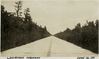 McCarthy Album 11, Photograph 039
 Caption: "Louisiana Highway, June 12, 34." A highway in Louisiana recedes into the distance, flanked by tall vegetation.
-
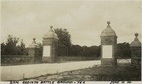 McCarthy Album 11, Photograph 038
 Caption: "San Jacinto Battle Ground -- Tex, June 11 34." View of the gated entry to the San Jacinto Battleground. The site was the location of the Battle of San Jacinto, in which the Texan Army (led by Sam Houston) defeated the Mexican army (led by General Antonio López de Santa Anna), paving the way for the formation of the Republic of Texas. A Texas Historic Site, the battleground was also declared a National Historic Landmark in 1960.
-
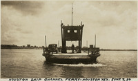 McCarthy Album 11, Photograph 037
 Caption: "Houston Ship Channel Ferry -- Houston Tex. June 9, 34." View of a ferry with a single vehicle on board, crossing the Houston Ship Channel. The dredged channel was opened in 1914 as part of the Port of Houston.
-
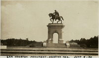 McCarthy Album 11, Photograph 036
 Caption: "Sam Houston Monument -- Houston Tex. June 8, 34." View of the San Houston Monument, a twenty-foot-tall bronze sculpture designed by Enrico Cerracchio and dedicated in 1925. The sculpture commemorates Sam Houston, a prominent soldier and politician who served as the first and third President of the Republic of Texas before its annexation to the U.S. Houston also served as Governor of Texas and as a U.S. Senator for both Texas and Tennessee.
-
 McCarthy Album 11, Photograph 035
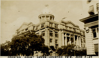
 Caption: "Houston Court House -- Houston Tex. June 7, 34." View of the Harris County Courthouse, a neoclassical building constructed in 1910 and designed by Dallas architectural firm Lang & Witchell. It was the fifth courthouse to be built on the site.
-
 McCarthy Album 11, Photograph 034
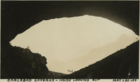
 Caption: "Carlsbad Caverns -- Inside Looking Out, May, 30, 34." View looking out of the mouth of Carlsbad Cavern, a series of natural underground chambers including the "Big Room," the fifth-largest such chamber in North America with a length of 1,000 feet, a width of 625 feet, and a maximum height of 255 feet. The site was named Carlsbad Cave National Monument in 1923, and declared Carlsbad Caverns National Park in 1930.
-
 McCarthy Album 11, Photograph 033b
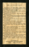
 One side of a flier handed out by the San Antonio Reptile Garden in the mid-1930s entitled "Reptile Facts." The Reptile Garden opened in the 1930s as a fundraising facility for the Witte Museum. The Garden featured turtle races, snake handling demonstrations, fried rattlesnake meat, and rattlesnake dinner fund raisers. It also became a research center for the use of antivenom. The Garden closed in the early 1940s, its live snakes donated to the San Antonio Zoo.
-
 McCarthy Album 11, Photograph 033a
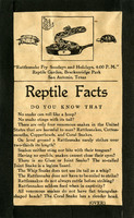
 One side of a flier handed out by the San Antonio Reptile Garden in the mid-1930s entitled "Reptile Facts." The Reptile Garden opened in the 1930s as a fundraising facility for the Witte Museum. The Garden featured turtle races, snake handling demonstrations, fried rattlesnake meat, and rattlesnake dinner fund raisers. It also became a research center for the use of antivenom. The Garden closed in the early 1940s, its live snakes donated to the San Antonio Zoo.
-
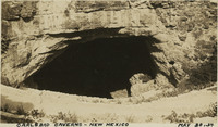 McCarthy Album 11, Photograph 033
 Caption: "Carlsbad Caverns -- New Mexico, May 30, 34." View looking into dark cave mouth of Carlsbad Cavern, a series of natural underground chambers including the "Big Room," the fifth-largest such chamber in North America with a length of 1,000 feet, a width of 625 feet, and a maximum height of 255 feet. The site was named Carlsbad Cave National Monument in 1923, and declared Carlsbad Caverns National Park in 1930.
-
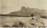 McCarthy Album 11, Photograph 032
 Caption: "Signal Peak -- Guadalupe Mts. 10,000 ft alt. New Mexico, May 29, 34." View of Guadalupe Peak (also known as Signal Peak), the highest natural point in Texas with an elevation of 8,751 feet above sea level.
-
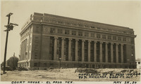 McCarthy Album 11, Photograph 031
 Caption: "Court House -- El Paso Tex. Population of El Paso 100,000, 80% Mexicans. 4000 ft. alt. May 28, 34." View of the El Paso County Courthouse, built in 1917 and designed by Henry Charles Trost. It is not known where William McCarthy got the statistics he quotes in the caption.
-
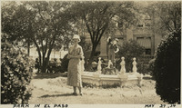 McCarthy Album 11, Photograph 030
 Caption: "Park in El Paso, May 27, 34." Grace McCarthy standing in a park, in front of statue of a young boy.