-
 McCarthy Album 11, Photograph 176
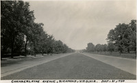
 Caption: "Chamberlayne Avenue, Richmond, Virginia. July, [sic] 21, 1934." View of a wide thoroughfare, with a grass median, lined by trees.
-
 McCarthy Album 11, Photograph 175
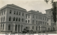
 Caption: "Post Office, Richmond, Virginia, July 21, 1934." View of the Richmond Custom House and Post Office. The Custom House, the first federal building in Richmond, was designed by Ammi Burnham Young in 1858. The post office was located on the first floor (for easy access by citizens), the custom house occupied the second floor, and the third floor held a federal courtroom. The building was expanded between 1887 and 1889 to include two short wings on either side of the facade. A story was added to the building in 1910, and wings added in 1910 and 1930, so that now the building occupies the entire block.
-
 McCarthy Album 11, Photograph 174
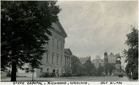
 Caption: "State Capitol, Richmond, Virginia. July 21, 1934." Virginia's State Capitol is visible in the left side of this photograph, while the Virginia Washington Monument can be seen at the right. The Capitol, designed largely by Thomas Jefferson and French architect Charles-Louis Clérisseau, was sufficiently complete by October 1792 for the Virginia General Assembly to meet within its walls. The building served as the capitol of the Confederacy during the Civil War. The Virginia Washington Monument, completed in 1869, features a 21-foot-tall statue of George Washington, mounted on a horse.
-
 McCarthy Album 11, Photograph 173
 Caption: "Jefferson Davis Highway. U.S. No. 1. Virginia. July 20, 34." Grace McCarthy is standing next to a U.S. Route 1 sign along a highway in Virginia. The Jefferson Davis Highway project was begun by the United Daughters of the Confederacy (UDC). As auto tourism increased across the U.S., so to did the need for roads on which to drive. Private interests such as the UDC began to develop routes across the country, but with no central administrating organization the routes were haphazard and confusing. The UDC planned a route that was to stretch from Virginia across the southern U.S. to San Diego, but the entire route never materialized. The federal government stepped in to impose a numbering system on various routes across the nation. That portion of the planned Jefferson Davis Highway through Virginia was numbered as U.S. Route 1.
-
 McCarthy Album 11, Photograph 172
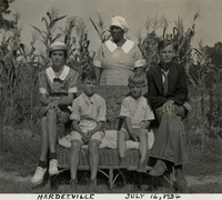
 Caption: "Hardeeville, July 16, 1934." Four unidentified white children posing with an unidentified African-American woman, possibly their nanny given the manner of dress of all parties.
-
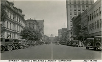 McCarthy Album 11, Photograph 171
 Caption: "Street Scene, Raleigh, North Carolina, July 19, 1934." Busy street in Raleigh, lined with parked cars. The dome and columned entryway of North Carolina's Capitol can be seen in the distance.
-
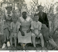 McCarthy Album 11, Photograph 170
 Caption: "Hardeeville, S.C. July 16, 1934." Four unidentified white children posing with an unidentified African-American woman, possibly their nanny, given the manner of dress of all parties.
-
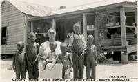 McCarthy Album 11, Photograph 169
 Caption: "Negro Home and Family, Hardeeville, South Carolina, July 16, 1934." Unidentified woman posing with several children in front of a small home. Another woman can be glimpsed seated on the porch of the home in the background.
-
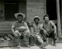 McCarthy Album 11, Photograph 168
 Two men, a woman, and a child, all unidentified, posing on a porch in Hardeeville. *PLEASE NOTE:* Original caption removed due to sensitive content. To view the original photograph with caption, please contact the California State Archives Reference Desk
-
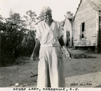 McCarthy Album 11, Photograph 167
 Caption: "Negro Lady, Hardeville [sic], S.C. July 16, 1934." Unidentified woman posing in front of a dilapidated home.
-
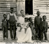 McCarthy Album 11, Photograph 166
 Caption: "Negro Family, Hardeeville, S.C. July 16, 1934." Unidentified woman posing with several children.
-
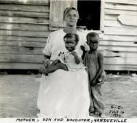 McCarthy Album 11, Photograph 165
 Caption: "Mother, Son and Daughter, Hardeeville, S.C., July 16, 1934." Unidentified woman posing with two small children.
-
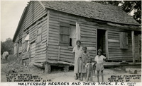 McCarthy Album 11, Photograph 164
 Caption: "Walterboro Negroes and Their Shack. If the Window Wont [sic] Stay Closed, Put a Stick Up to It, You Wont [sic] Break the Glass. House Foundation Gone But They Live Merrily On. July 17, 1934." Unidentified family posing in front of a dilapidated home in Walterboro.
-
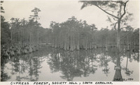 McCarthy Album 11, Photograph 163
 Caption: "Cypress Forest, Society Hill, South Carolina. July 16, 1934." A grove of cypress trees near the town of Society Hill.
-
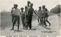 McCarthy Album 11, Photograph 162
 Caption: "Negro Boys Dancing, Savannah, Georgia. Savannah Population is 50% Negroes, July 15, 34." A group of young boys of various ages show off their dancing skills along a country road. According to census information available online, the population of Savannah in 1930 consisted of 54.2% white, 45.7% black.
-
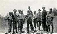 McCarthy Album 11, Photograph 161
 Caption: "Negro Boys Singing, Savannah, Georgia. July 15, 34." A group of young boys of various ages pose for a photograph along a country road.
-
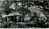 McCarthy Album 11, Photograph 160
 Caption: "Slave Dwellings at the Old Hermitage, Savannah, Ga. July 15, 1934." A row of small brick houses surrounded by trees. The Old Hermitage was a 400-acre plantation on the Savannah River, owned by Henry McAlpin. McAlpin not only conducted farming operations at the plantation, but also manufactured bricks, barrels, cast iron products, and lumber. For that reason, he built the slave quarters for the plantation from brick, rather than wood as was common for most other plantations in the South.
-
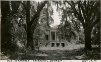 McCarthy Album 11, Photograph 159
 Caption: "Old Hermitage, Savannah, Georgia, July 15, 1934." The remains of the Hermitage Plantation mansion, built in 1830, can be seen through trees draped with Spanish moss. Hermitage was a 400-acre plantation on the Savannah River, owned by Henry McAlpin. McAlpin not only conducted farming operations at the planation, but also manufactured bricks, barrels, cast iron products, and lumber.
-
 McCarthy Album 11, Photograph 158
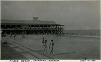
 Caption: "Tybee Beach, Savannah, Georgia, July 14, 1934." Beach scene with a small crowd of unidentified people enjoying the ocean waves and strolling in the sand. The large Tybrisa Pavilion, set on a wood pier, extends into the water. Tybee Beach is one of several beaches in Tybee Island, a town on an island of the same name located across the river from Savannah. The island became a popular tourist spot between the Civil War and the mid-twentieth century, particularly after the Central of Georgia Railway constructed a line to the island. To encourage tourists, the railroad built Tybrisa Pavilion in 1891. It featured a large dance floor that became popular on the Big Band circuit, but was destroyed by fire in 1967.
-
 McCarthy Album 11, Photograph 157
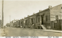
 Caption: "Negro Homes, Savannah, Georgia. July 14, 1934." Row of identical small homes set closely together, each with a small front porch. Several unidentified people can be seen on a few of the porches.
-
 McCarthy Album 11, Photograph 156
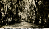
 Caption: "Bonaventure Cemetery Driveway, Savannah, Georgia, July 14, 1934." Road stretching into the distance, flanked by trees dripping with Spanish moss. The Bonaventure Cemetery in Savannah originated in a private cemetery on a plantation. The plantation was sold in 1846. Major William H. Wiltberger, son of the new owner, formed the Evergreen Cemetery Company in 1868. The City of Savannah purchased the company and cemetery in 1907, and changed its name to Bonaventure Cemetery.
-
 McCarthy Album 11, Photograph 155
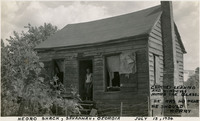
 Caption: "Negro Shack, Savannah, Georgia, Chimney Leaning and Windows Minus the Glass. He has No Pane. He Should Worry, July 13, 1934." View of a small home, with a leaning chimney on one side. An unidentified man stands in the doorway.
-
 McCarthy Album 11, Photograph 154
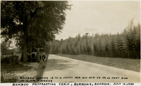
 Caption: "Bamboo Grows 12 to 16 Inches Per Day and 50 or 60 Feet High in 6 or 7 Weeks. Bamboo Propagating Farm, Burrows, Georgia. July 13, 1934." Grace McCarthy stands next to an automobile on the side of a road under trees. The other side of the road is flanked by rows of bamboo plants. This may be part of the U.S. Department of Agriculture's Savannah Plant Introduction Station, established in approximately 1919 in the Burroughs Station area southwest of Savannah. The station remained open until 1979, when it was closed by USDA budgetary downsizing. The property was subsequently deeded to the University of Georgia, in 1983.
-
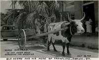
 McCarthy Album 11, Photograph 153
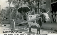
 Caption: "York Hazzard. He has Never Been Arrested for Speeding. Old Negro and His Mode of Traveling, Darien, Ga. July 13, 1934." York Hazzard, an elderly man of African-American ethnicity, seated in a small wooden cart drawn by a cow or steer. In this photograph Hazzard is sheltered from the sun by an umbrella. An automobile is parked on the street behind the cart.
-
 McCarthy Album 11, Photograph 152
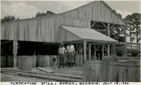
 Caption: "Turpentine Still, Darien, Georgia. July 13, 1934." Two unidentified men standing in front of a large barn or shed, with numerous barrels surrounding them, presumably for turpentine and other resin products. After being harvested from pine trees, resin is then subjected to steam distillation to evaporate off the turpentine.
-
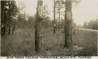 McCarthy Album 11, Photograph 151
 Caption: "Pine Trees Yielding Turpentine, Rosin [sic], Etc. Florida, July 13, 1934." A group of pine trees with bark removed in a "V"-shaped, or "catface" pattern to encourage production of resin, from which turpentine is made. Small buckets hang at the end of each "V" to catch the resin. This turpentine farm may actually be in Georgia, rather than Florida.
-
 McCarthy Album 11, Photograph 150
 Caption: "York Hazzard. He has Never Been Arrested for Speeding. Old Negro and His Mode of Traveling, Darien, Ga. July 13, 1934." York Hazzard, an elderly man of African-American ethnicity, seated in a small wooden cart drawn by a cow or steer. An automobile is parked on the street behind the cart.
-
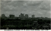 McCarthy Album 11, Photograph 149
 Caption: "Jacksonville, Florida. At St. John's River Bridge. July 11, 1934." View of Jacksonville's skyline.
-
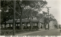 McCarthy Album 11, Photograph 148
 Caption: "Spanish Slave Market, St. Augustine, Florida. July 10, 1934." An open-air pavilion with a gabled roof and six bays appears in the center of this photograph, somewhat obscured by surrounding trees and vegetation. The waterfront site on which the pavilion sits has served St. Augustine as a marketplace since the city's founding in the sixteenth century, for food, commercial goods, and for slaves. The pavilion in the photograph was constructed in 1888, after a fire burned down the previous structure. In the twentieth century, entrepreneurs used the slave market aspect of the site's history as a hook to entice northern tourists into St. Augustine's historic quarter. The market has often served as a rallying site for protestors, from suffragettes to protestors of the war in Iraq. Various civil rights marches held around the market in the 1960s attracted such luminaries as Dr. Martin Luther King, Jr. and Andrew Young.
-
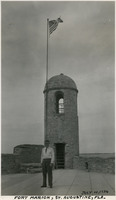 McCarthy Album 11, Photograph 147
 Caption: "Fort Marion, St. Augustine, Fla. July 10, 1934." William McCarthy standing in front of a corner tower on the ramparts of Castillo de San Marcos (Castle of Saint Mark). The core structures of this coastal defense fort were completed by Spanish forces in 1695. Numerous additions, renovations, and repairs have occurred since that time. When Spain ceded Florida to the U.S. in 1821, the Castillo was designated a U.S. Army base and renamed Fort Marion, in honor of Frances Marion (also known as the Swamp Fox, Marion was an American Revolutionary War hero known for his guerilla war tactics). The fort was deactivated in 1933, and turned over to the National Park Service.
-
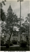 McCarthy Album 11, Photograph 146
 Caption: "Old Cathedral, St. Augustine." View of the tower, columned entryway, and bells of Cathedral Basilica of St. Augustine. The oldest church in Florida, the first building on the site was established in 1565. The cathedral seen in this photograph (which exists today) was constructed between 1793 and 1797. The cathedral was designated a National Historic Landmark in 1970.
-
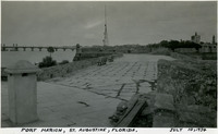 McCarthy Album 11, Photograph 145
 Caption: "Fort Marion, St. Augustine, Florida. July 10, 1934." Walkway atop what appears to be the ramparts of the Castillo de San Marcos (Castle of Saint Mark). The core structures of this coastal defense fort were completed by Spanish forces in 1695. Numerous additions, renovations, and repairs have occurred since that time. When Spain ceded Florida to the U.S. in 1821, the Castillo was designated a U.S. Army base and renamed Fort Marion, in honor of Frances Marion (also known as the Swamp Fox, Marion was an American Revolutionary War hero known for his guerilla war tactics). The fort was deactivated in 1933, and turned over to the National Park Service.
-
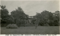 McCarthy Album 11, Photograph 144
 Caption: "John D. Rockefeller Mansion, Ormond [sic], Florida. July 10, 1934." A large mansion can be glimpsed through surrounding trees and other vegetation in this photograph. The mansion is known as the Casements, for the numerous casement windows incorporated into its structure. Built in 1914 in Ormond Beach, John D. Rockefeller purchased the home in 1918 for use as a winter residence. After Rockefeller died in 1937, the property was sold several times, until the City of Ormond Beach bought it in 1973. The city renovated it for use as a cultural and community center, a purpose which it still serves.
-
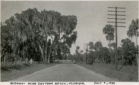 McCarthy Album 11, Photograph 143
 Caption: "Highway Near Daytona Beach, Florida. July 9, 1934." A road stretches toward a curve in the distance, flanked by trees dripping with Spanish moss, and palm trees.
-
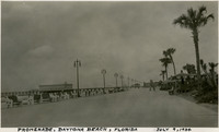 McCarthy Album 11, Photograph 142
 Caption: "Promenade, Daytona Beach, Florida, July 9, 1934." Wide promenade along the beach at Daytona Beach, featuring a row of benches at the left (seaside) and covered seating areas on the right, with palm trees. Daytona Beach was created when the neighboring towns of Daytona, Daytona Beach, Kingston, and Seabreeze merged in 1926. The area's beach was already well-known in both tourist and automobile circles
-
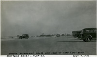 McCarthy Album 11, Photograph 141
 Caption: "Where Automobile Races are Held on Hard Sandy Beach, Daytona Beach, Florida. July 9, 1934." This photograph illustrates the wide, hard-packed sands of the beach at Daytona Beach, used by early motorists as a race track and testing ground for new vehicles. Bathers enjoy the surf to the left, while many automobiles are visible in the rest of the photograph.
-
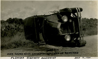 McCarthy Album 11, Photograph 140
 Caption: "Over Turned Buick Caused by Blow Out on Rear Tire, Florida Highway Accident, July 8, 1934." An automobile lying on its side after having blown out a rear tire on a Florida highway.
-
 McCarthy Album 11, Photograph 139
 Caption: "Lake View Avenue Bridge, Palm Beach, Florida. July 8, 1934." View of the Royal Park Bridge, a bascule bridge constructed in the 1920s. This bridge has since been replaced with a more modern structure.
-
 McCarthy Album 11, Photograph 138
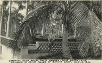
 Caption: "Embassy Club Royal Palm Garden -- Palm Beach, Fla. Designed by Adison [sic] Mizner of Benicia Calif. July 8, 1934." William McCarthy leaning on an ornamental fence in a garden, surrounded by palm trees and manicured hedges. The Embassy Club was a popular Palm Beach club in the mid-twentieth century.
-
 McCarthy Album 11, Photograph 137
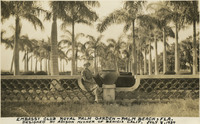
 Caption: "Embassy Club Royal Palm Garden -- Palm Beach, Fla. Designed by Adison [sic] Mizner of Benicia Calif. July 8, 1934." Grace McCarthy sitting on an ornamental fence in a garden, surrounded by palm trees. The Embassy Club was a popular Palm Beach club in the mid-twentieth century.
-
 McCarthy Album 11, Photograph 136
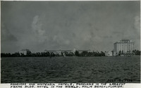
 Caption: "Ponciana [sic] and Whitehall Hotels. Ponciana {sic] is the Largest Frame Bldg. Hotel in the World. Palm Beach, Florida. July 8, 1934." Both the Royal Poinciana Hotel (center) and the Whitehall Hotel (far right) can be seen in this photograph, taken from across Lake Worth. The Royal Poinciana, built by Henry Flagler as a resort retreat for wealthy guests, opened in 1894. Renovations eventually enlarged the hotel to a length of 1,800 feet, with over three miles of corridors and hallways, and rooms for over 1,000 guests. At one point, it was reputed to be the largest wood structure in the world. Attendance declined in the 1920s, however, as tourists were attracted to more modern facilities. Damage by a hurricane and the Great Depression combined to close the hotel in 1934. The building was razed a year later. The Whitehall Hotel started its existence as a mansion, also built by Flagler, as a present for his wife. After Flagler's death in 1913, the home was sold to a group of investors who erected an eleven-story tower and converted the entire complex to use as a resort hotel. In 1959, the Henry Morrison Flagler Museum purchased the building. It now serves as a museum.
-
 McCarthy Album 11, Photograph 135
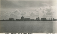
 Caption: "Palm Beach -- View from Beach. July 8, 1934." View of Palm Beach's skyline and waterfront from a beach across the harbor.
-
 McCarthy Album 11, Photograph 134
 Caption: "An Avenue of Cocoanut [sic] Palms, Palm Beach, Florida, July 8, 1934." Palm trees and manicured hedges line this street in Palm Beach.
-
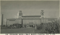 McCarthy Album 11, Photograph 133
 Caption: "The Breakers Hotel, Palm Beach, Florida. July 8, 1934." The imposing resort hotel shown in this photograph was originally called the Palm Beach Inn when it opened in 1896. The original hotel burned down in 1903, reopened in 1904, and burned again in 1925. After the 1925 fire, the building's owners abandoned wood frame construction in favor of concrete. The new hotel building, as shown in this photograph, was reopened in December 1926.
-
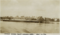 McCarthy Album 11, Photograph 132
 Caption: "Havana Water Front -- Havana, Cuba. July 4, 1934." View of the waterfront at Havana from across the harbor.
-
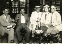 McCarthy Album 11, Photograph 131
 Caption: "Sloppy Joes Bar, Havana July 4, 1934." William and Grace McCarthy (at the far right) having drinks with three unidentified men in Sloppy Joe's Bar, a drinking establishment owned by Jose Garcia. American tourists flocked to the bar in the 1930s and 1940s, as it attracted illustrious visitors such as John Wayne and Clark Gable. The bar was closed in 1959 after the Cuban revolution.
-
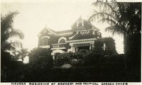 McCarthy Album 11, Photograph 130
 Caption: "Havana Residence of Brewery and Tropical Garden Owner." Elaborate residence, possibly of a member of the Herrera family, founders of Cuba's first brewery, Cerveceria La Tropical.
-
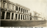 McCarthy Album 11, Photograph 129
 Caption: "Dwellings on Malecon Boulevard -- Havana. July 4, 1934." The Malecón is a broad esplanade and seawall that extends approximately five miles from Old Havana to the mouth of Havana's harbor. Construction began on the Malecón in 1901, and continued until the early 1950s. This photograph shows several buildings along the Malecón.
-
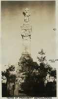 McCarthy Album 11, Photograph 128
 Caption: "Tomb of President Gomez, Havana. July 4th 1934." José Miguel Gómez y Gómez was instrumental in the Cuban War of Independence (1895-1898), and also served as Cuba's President from 1909-1913. Although he died in New York, his remains were interred in the Colon Cemetery in Havana.
-
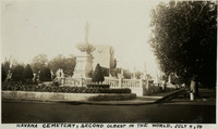 McCarthy Album 11, Photograph 127
 Caption: "Havana Cemetery, Second Oldest in the World. July 4, 34." Several memorials in Colon Cemetery can be seen in this photograph. Founded in 1876, Colon Cemetery replaced Havana's first cemetery, Espada Cemetery, after a cholera epidemic in 1868 revealed the need for a new, larger facility. Today, the Colon Cemetery holds more than 800,000 graves. It is not known where William McCarthy found reference to this being the "second oldest" cemetery in the world, as California State Archives staff could not verify that statistic.