-
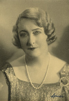 McCarthy Album 11, Photograph 223
 No caption, c. 1934. Undated photograph of an unidentified woman, possibly taken in a photography studio.
-
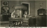 McCarthy Album 11, Photograph 222
 Caption: "Guest Room, Daybreak, Long Island, New York. Aug. 21, 1934." Grace McCarthy seated at a desk reading a book, with a bed to one side and a dresser on the other. See also 96-07-08-alb09-174.
-
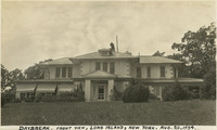 McCarthy Album 11, Photograph 221
 Caption: "Daybreak. Front View, Long Island, New York. Aug. 20, 1934." Residence of John Shields, on Long Island in the Daybreak Estate area. See also 96-07-08-alb09-159.
-
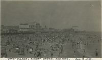 McCarthy Album 11, Photograph 220
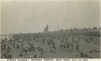
 Caption: "Coney Island, Sunday Crowd. New York. Aug. 19, 1934." Very crowded beach scene on New York's Coney Island. The construction of several resort hotels on the island in the 1870s and 1880s encouraged construction of amusement parks to provide tourist destinations. Coney Island has hosted several large amusement parks over the years, including one of the world's first roller coasters (built in 1884). Numerous smaller attractions were available as well. The island's popularity peaked in the World War II era, but despite some decline is still a world-renowned recreation area.
-
 McCarthy Album 11, Photograph 219
 Caption: "Coney Island. Sunday Crowd. New York. Aug. 19, 1934." Very crowded beach scene on New York's Coney Island. The construction of several resort hotels on the island in the 1870s and 1880s encouraged construction of amusement parks to provide tourist destinations. Coney Island has hosted several large amusement parks over the years, including one of the world's first roller coasters (built in 1884). Numerous smaller attractions were available as well. The island's popularity peaked in the mid-twentieth century, in the World War II era, but despite some decline is still a world-renowned recreation area.
-
 McCarthy Album 11, Photograph 218
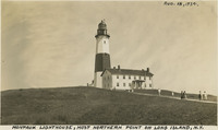
 Caption: "Montauk Lighthouse, Most Northern Point on Long Island, N.Y., Aug. 18, 1934." The Montauk Lighthouse, first lit in 1797, was the first lighthouse built in New York. Ezra L'Hommedieu designed the building as well as choosing its site on the eastern edge of Long Island. A renovation in 1860 raised the lighthouse to its current height of more than 110 feet. A larger lantern was installed at that time as well. Electrified in 1940, it is now a National Historic Landmark as well as an active lighthouse.
-
 McCarthy Album 11, Photograph 217
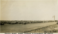
 Caption: "Jones's [sic] Beach. Where Thousands of Automobiles are Parked. Long Island, N.Y. Aug. 17, 1934." Photograph of a large parking area full of automobiles on Jones Beach Island. The Long Island State Park Commission began to develop the area for a park in the 1920s, dredging enough sand to connect several of the barrier islands south of Long Island and raising the elevation of the islands by fourteen feet to create one large park. It opened to the public in 1929. It is now a state park, with an estimated six million visitors each year.
-
 McCarthy Album 11, Photograph 216
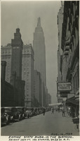
 Caption: "Empire State Bldg. in the Distance. Height 1250 Feet, 102 Stories. 34th St. New York. Aug. 16, 1934." Street scene dominated by the Empire State Building rising a few blocks away. Construction began on this iconic 102-story building, designed by William F. Lamb, in 1930. Completed by early 1931, it held the title of world's tallest building for almost 40 years, until being surpassed in 1970 by the construction of the World Trade Center's North Tower. It is now the fifth-tallest building in the U.S., and the 28th-tallest in the world.
-
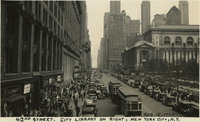 McCarthy Album 11, Photograph 215
 Caption: "42nd Street. City Library on right, New York City, N.Y. Aug. 15, 1934." Busy street scene along New York City's 42nd Street, showing numerous pedestrians, automobiles, and street trolleys. On the right side of the photograph can be seen the side of the New York Public Library's main building, opened in 1911. At the time of its opening, the Library's main reading room was the largest of its kind in the world.
-
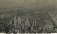 McCarthy Album 11, Photograph 214
 Caption: "Central Park. View from Radio City Blg. New York. Aug. 14, 1934." Bird's eye view of New York City's 843-acre Central Park. Landscape architect Frederick Law Olmstead and architect Calvert Vaux designed the park, the first portion of which opened to the public in 1858. It was designated a National Historic Landmark in 1962.
-
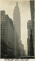 McCarthy Album 11, Photograph 213
 Caption: "Empire State Bldg. 1250 Ft. High, 102 Stories. 34th St. New York. Aug. 13, 1934." View from the sidewalk, looking up at the Empire State Building. Construction began on this iconic 102-story building, designed by William F. Lamb, in 1930. Completed by early 1931, it held the title of world's tallest building for almost 40 years, until being surpassed in 1970 by the construction of the World Trade Center's North Tower. It is now the fifth-tallest building in the U.S., and the 28th-tallest in the world.
-
 McCarthy Album 11, Photograph 212
 Caption: "The Ghetto with its Street Venders [sic], New York City. Aug. 12, 1934." Crowded street scene in New York City, with numerous street vendors selling a variety of goods, including vegetables and toiletry supplies.
-
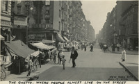 McCarthy Album 11, Photograph 211
 Caption: "The Ghetto. Where People Almost Live on the Street, New York City, Aug. 12, 1934." Crowded street scene in New York City, with numerous open-air stalls and storefronts hawking wares.
-
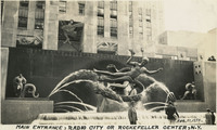 McCarthy Album 11, Photograph 210
 Caption: "Main Entrance, Radio City or Rockefeller Center, N.Y. Aug 11, 1934." William McCarthy standing in front of the Prometheus sculpture in Rockefeller Center. The gilded bronze statue, designed by sculptor Paul Manship, was erected in 1934 in the middle of New York's Rockefeller Center.
-
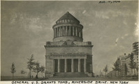 McCarthy Album 11, Photograph 209
 Caption: "General U.S. Grants [sic] Tomb, Riverside Drive. New York, Aug. 10, 1934." The remains of Ulysses S. Grant, 18th President of the U.S. and Commanding General of the Union Army during the last year of the Civil War, were laid to rest in this elaborate tomb. Grant died in 1885, but construction on the tomb did not begin until 1891. Grant's remains were transferred to the tomb on April 27, 1897.
-
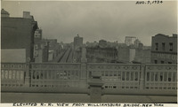 McCarthy Album 11, Photograph 208
 Caption: "Elevated R.R. View from Williamsburg Bridge. New York, Aug. 9, 1934." Bird's eye view of a portion of New York City, from the Williamsburg Bridge over the East River. An elevated railway dominates the center of the photograph.
-
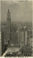 McCarthy Album 11, Photograph 207
 Caption: "Woolworth Bldg. Broadway, N.Y. Aug. 8, 1934." Bird's eye view of a portion of New York City, with the Woolworth Building at the left. Constructed between 1910 and 1920 and designed by architect Cass Gilbert, the Neo-Gothic building was once the tallest in the world at 792 feet.
-
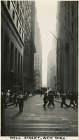 McCarthy Album 11, Photograph 206
 Caption: "Wall Street, New York. Aug 8 1934." Street scene on Wall Street, New York City. Bustling crowds fill the sidewalks while tall buildings loom on each side of the street.
-
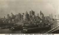 McCarthy Album 11, Photograph 205
 Caption: "Lower Manhattan, N.Y. View from Brooklyn Bridge. Aug. 7, 1934." View of Manhattan's skyline and wharf facilities.
-
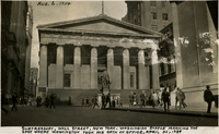 McCarthy Album 11, Photograph 204
 Caption: "Subtreasury, Wall Street, New York. Washingion [sic] Statue Marking the Spot Where Washington took his Oath of Office, April 30, 1789, Aug. 6, 1934." The original building on this site, constructed in 1700, served as New York's City Hall, then as the Capitol for the newly-created United States under the Constitution of 1789, and was the site of George Washington's inauguration as the first U.S. President. The original building was demolished in 1812, but a new building, designed to house the U.S. Custom House for the Port of New York, was opened in 1842. It is this building that is seen in the photograph. The new building subsequently housed one of six U.S. sub-treasuries between 1862 and 1920. A statue of George Washington (John Quincy Adams Ward, sculptor) was erected in front of the building in 1882, to commemorate the approximate site of Washington's inauguration.
-
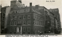 McCarthy Album 11, Photograph 203
 Caption: "Frances [sic] Tavern, New York. Where Washington Took Leave of Offices and Disbanded the Troops at Conclusion of the Revolutionary [sic] War. Aug. 5, 1934." Built as a family home for Etienne "Stephen" DeLancey in 1719, this building was converted to use as a tavern in 1762. It served many important functions before, during, and after the Revolutionary War, but several fires in the nineteenth century erased the building's original appearance. The Sons of the Revolution purchased the property in 1904 and embarked upon extensive restoration plans in 1907, supervised by William Mersereau. The building is now used as a museum and art gallery.
-
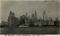 McCarthy Album 11, Photograph 202
 Caption: "The Battery, Lower Manhattan, New York, N.Y [sic], Aug. 4, 1934." This photograph shows the Manhattan skyline, as well as the Battery, a 25-acre park at the tip of Manhattan Island. The park was named for the artillery batteries that used to protect the city and its harbor from this location.
-
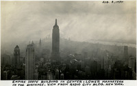 McCarthy Album 11, Photograph 201
 Caption: "Empire State Building in Center, Lower Manhattan in the Distance. View from Radio City Bldg. New York. Aug. 3, 1934." The Empire State Building dominates this bird's eye view of New York. Construction began on this iconic 102-story building, designed by William F. Lamb, in 1930. Completed by early 1931, it held the title of world's tallest building for almost 40 years, until being surpassed in 1970 by the construction of the World Trade Center's North Tower. It is now the fifth-tallest building in the U.S., and the 28th-tallest in the world.
-
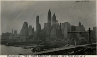 McCarthy Album 11, Photograph 200
 Caption: "Manhattan. View from Brooklyn Bridge. New York City, N.Y [sic], Aug. 2, 1934." View of the Manhattan skyline as it appeared in 1934.
-
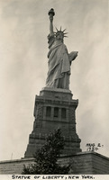 McCarthy Album 11, Photograph 199
 Caption: "Statue of Liberty, New York. Aug 2, 1934." View of the Statue of Liberty on Bedloe Island (now called Liberty Island). Designed by French sculptor Frédéric Auguste Bartholdi, the now-iconic statue was a gift from the people of France to the U.S. Built in segments in France by Gustave Eiffel (also famous for building the Eiffel Tower in Paris), the pieces were shipped from Paris to New York in 1885 and assembled. The Statue of Liberty was subsequently dedicated on October 28, 1886.
-
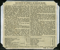 McCarthy Album 11, Photograph 198b
 No caption. Clipping from an unidentified newspaper or pamphlet regarding the history of the Statue of Liberty in New York Harbor.
-
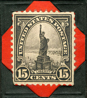 McCarthy Album 11, Photograph 198a
 No caption. Commemorative U.S. postage stamp issued in 1931, featuring the Statue of Liberty, with the word "Liberty" on a scroll across the bottom of the stamp. This was only the second time the Statue of Liberty was featured on a postage stamp.
-
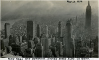 McCarthy Album 11, Photograph 198
 Caption: "New York Sky Scrapers. Empire State bldg. on Right. Aug. 2, 1934." Bird's eye view of New York City showing a forest of sky scrapers, the tallest being the Empire State Building on the right side of the photograph.
-
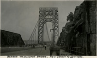 McCarthy Album 11, Photograph 197
 Caption: "George Washington Bridge. New Jersey to New York. Aug 1, 1934." This suspension bridge, designed by Othmar Ammann, spans the Hudson River between Manhattan in New York City, and Fort Lee, New Jersey. Constructed between 1927 and 1931, the bridge included the longest main span in the world at the time, a record it held until construction of the Golden Gate Bridge was completed in 1937. It was originally built with only one deck, but a second deck opened in 1962. Still in active use today, it carried over 51 million vehicles in 2016.
-
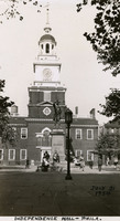 McCarthy Album 11, Photograph 196
 Caption: "Independence Hall -- Phila. July 31, 1934." A view of the steeple and bell tower of Independence Hall in Philadelphia, site of the debate over and signing of both the Declaration of Independence and the U.S. Constitution. Completed in 1753 for the use of the Pennsylvania Province's colonial legislature, it was also the site of a 1915 convention marking the formation of the League to Enforce Peace, predecessor entity to the United Nations. The Georgian-style building, designed by Edmund Woolley and Andrew Hamilton, has undergone several renovations. Only the central portion of the building is original -- all other portions of the building have been rebuilt at some point in its past. This building also housed the Liberty Bell until 1976, when the bell was moved to the Liberty Bell Center across the street.
-
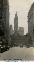 McCarthy Album 11, Photograph 195
 Caption: "City Hall, Broad St. Philadelphia, PA. July 31, 1934." Street scene along Broad Street in Philadelphia, with the City Hall building visible in the middle of the photograph. Philadelphia's City Hall was built in 1901, designed by architect John McArthur, Jr. At completion, the building was the world's tallest inhabitable structure. It is the largest municipal building in the world, with almost 700 rooms. A 37-foot-tall statute of William Penn (founder of Philadelphia) adorns the peak of the structure, created by Alexander Milne Calder.
-
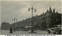 McCarthy Album 11, Photograph 194
 Caption: "A Block of Broad St. Homes, Philadelphia, PA. July 31, 1934." Row houses along Philadelphia's Broad Street.
-
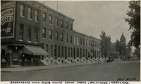 McCarthy Album 11, Photograph 193
 Caption: "Apartments with their White Stone Steps, Baltimore, Maryland. July 30, 1934." View of several apartment buildings, almost identical, sheathed in brick with stone steps leading to the front doors.
-
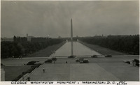 McCarthy Album 11, Photograph 192
 Caption: "George Washington Monument, Washington, D.C. July 29, 1934." The obelisk of the Washington Monument rises above the Reflecting Pool on National Mall in Washington, D.C. Built between 1848 and 1888 to commemorate George Washington (former Commander-in-Chief of the Continental Army and first President of the United States), the obelisk is the world's tallest stone structure at a height of 555 feet.
-
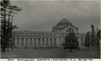 McCarthy Album 11, Photograph 191
 Caption: "New Smithsonian Institute, Washington, D.C. July 29, 1934." View of central, domed portion and wing of the National Museum of Natural History, one of ten Smithsonian Institute museums along National Mall in Washington, D.C. The museum opened in 1910.
-
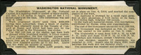 McCarthy Album 11, Photograph 190a
 This undated clipping from an unidentified newspaper provides a detailed description of the Washington Monument.
-
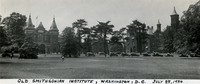 McCarthy Album 11, Photograph 190
 Caption: "Old Smithsonian Institute, Washington, D.C. July 28, 1934." Taken from across a park, this photograph shows the Smithsonian complex rising above surrounding trees. Built in 1855, it houses the Smithsonian Institute's administrative offices and information center.
-
 McCarthy Album 11, Photograph 189
 Caption: "U.S. Capitol Building in the distance. View Taken from the Washington Monument. Washington, D.C. July 27, 1934." Bird's eye view of a portion of the National Mall, between the Washington Monument and the U.S. Capitol Building.
-
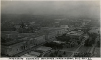 McCarthy Album 11, Photograph 188
 Caption: "Interstate Commerce Buildings, Washington, D.C. July 27, 1934, Taken from Washington Monument." Bird's eye view of the Department of Labor Building complex (which also included the offices of the Interstate Commerce Commission), constructed between 1932-1934.
-
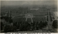 McCarthy Album 11, Photograph 187
 Caption: "Portion of Cities [sic] Beauty, Washington, D.C. July 26, 1934, Taken from Washington Capitol Dome." Bird's eye view of a portion of Washington, D.C., showing Upper and Lower Senate Parks.
-
 McCarthy Album 11, Photograph 186
 Caption: "Congressional Library, Washington, D.C. July 25, 1934. Taken from Washington Capitol Dome." A view of the Library of Congress. The Beaux Arts-style building was constructed between 1888 and 1894. It serves as the national library of the U.S., as well as the research library for the U.S. Congress.
-
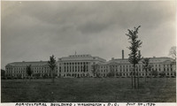 McCarthy Album 11, Photograph 185
 Caption: "Agricultural Building, Washington, D.C. July 24, 1934." The Administration Building for the U.S. Department of Agriculture, also called the Jamie L. Whitten Building, sprawls across this photograph. The enormous Beaux-Arts style building, designed by Rankin, Kellogg, and Crane, was constructed between 1903 and 1930.
-
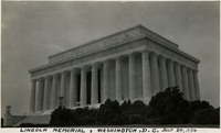 McCarthy Album 11, Photograph 184
 Caption: "Lincoln Memorial, Washington, D.C. July 24, 1934." View of the Lincoln Memorial's façade. The memorial's outer structure, styled after a Greek Doric temple, was designed by architect Henry Bacon, while the statue of Abraham Lincoln within was designed by Daniel Chester French. The memorial was dedicated in 1922.
-
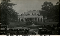 McCarthy Album 11, Photograph 183
 Caption: "The White House. Washington, D.C. July 23, 1934." East Wing of the White House in Washington, D.C. The Neoclassical-style residence and work place of the United States President, designed by James Hoban, was constructed between 1792 and 1800. See also 96-07-08-alb04-085 and 96-07-08-alb09-222.
-
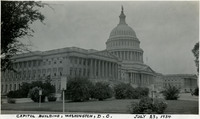 McCarthy Album 11, Photograph 182
 Caption: "Capitol Building, Washington, D. C. July 23, 1934." View of the domed United States Capitol, housing both the Senate and House of Representatives. Constructed between 1793 and 1800 and designed by architect William Thornton, the building has undergone several expansions, including the addition of the wedding-cake-style dome in the 1850s.
-
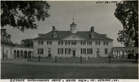 McCarthy Album 11, Photograph 181
 Caption: "George Washingions [sic] Home, Rear View, Mt. Vernon, Va. July 22, 1934." Rear view of Mount Vernon, the plantation home of George and Martha Washington. Built between 1758 and 1778, the Palladian-style mansion is now owned in trust by the Mount Vernon Ladies' Association and open to the public.
-
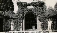 McCarthy Album 11, Photograph 180
 Caption: "George Washingtons [sic] Tomb, Mount Vernon, Virginia, July 22, 1934." The gated entrance to the tomb holding the remains of George Washington are seen in this photograph, overgrown by ivy. Two unidentified people stand at either side of the entry. The brick tomb was constructed after Washington's death in 1799.
-
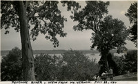 McCarthy Album 11, Photograph 179
 Caption: "Potomac River, View from Mt. Vernon. July 22, 1934." Trees obscure much of the photograph, but the Potomac River can be glimpsed in the distance.
-
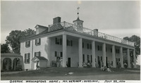 McCarthy Album 11, Photograph 178
 Caption: "George Washingtons [sic] Home, Mt. Vernon, Virginia. July 22, 1934." View of Mount Vernon, the plantation home of George and Martha Washington. Built between 1758 and 1778, the Palladian-style mansion is now owned in trust by the Mount Vernon Ladies' Association and open to the public.
-
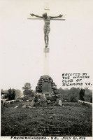 McCarthy Album 11, Photograph 177
 Caption: "Erected by the Women's Club of Richmond Va. Fredericksburg. VA. July 21, 1934." View of the Aquia Crucifix Monument in Virginia's Stafford County. Erected in 1930, the monument consists of a crucifix atop a stone marker with a plaque.