-
 McCarthy Album 10, Photograph 307
 No Caption: An unidentified group of California Indian women and children standing in front of a wigwam covered in tree bark. A young child in front of the group is dressed in traditional clothing.
-
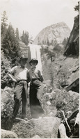 McCarthy Album 10, Photograph 306
 No Caption: William and Grace McCarthy standing on a rock near a waterfall at Yosemite National Park, c. 1935.
-
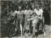 McCarthy Album 10, Photograph 305
 No Caption: A group of unidentified women and girls on bicycles at Yosemite National Park, c. 1935.
-
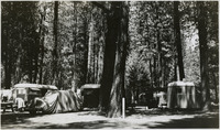 McCarthy Album 10, Photograph 304
 No Caption: An unidentified campground in Yosemite National Park, c. 1935.
-
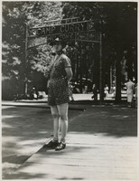 McCarthy Album 10, Photograph 303
 No Caption: Grace McCarthy is seen standing near the Camp Curry sign at Yosemite National Park, c. 1935. Camp Curry was established in 1899 and renamed Half Dome Village in 2016.
-
 McCarthy Album 10, Photograph 302
 No Caption: People at the overhanging rocks at Glacier Point, Yosemite National Park, c. 1935.
-
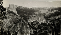
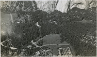 McCarthy Album 10, Photograph 301
 No Caption: A birds-eye view of Yosemite Valley with the Merced River running through it, c. 1935.
-
 McCarthy Album 10, Photograph 300
 Caption: "Happy Isles - Yosemite National Park," c. 1935, shows an unidentified rushing river.
-
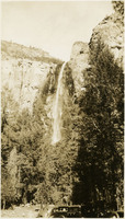
 McCarthy Album 10, Photograph 299
 No Caption: An unidentified waterfall at Yosemite National Park, c. 1935.
-
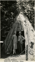 McCarthy Album 10, Photograph 298
 Caption: "Indian Wigwam, Yosemite National Park," c. 1935, shows Grace and William McCarthy standing at the entrance to an Indian abode covered in tree bark.
-
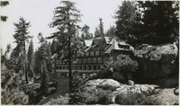 McCarthy Album 10, Photograph 297
 No Caption: An unidentified hotel in Yosemite National Park, C. 1935.
-
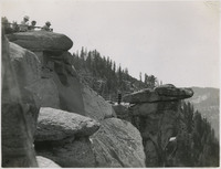
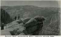 McCarthy Album 10, Photograph 296
 Caption: "Glacier Point - Overhanging Rock - Yosemite National Park," c. 1935, shows people standing on the overhanging rock of Glacier Point.
-
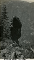 McCarthy Album 10, Photograph 295
 Caption: "Balance Rock - Yosemite," c. 1935, shows Grace McCarthy standing near a precariously balanced rock at Yosemite National Park.
-
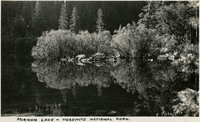 McCarthy Album 10, Photograph 294
 Caption: "Mirror Lake - Yosemite National Park," c. 1935.
-
 McCarthy Album 10, Photograph 293
 No Caption: An unidentified waterfall at Yosemite National Park, c. 1935.
-
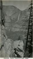 McCarthy Album 10, Photograph 292
 Caption: "Cascade Falls - Yosemite National Park," c. 1935.
-
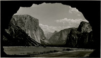
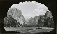 McCarthy Album 10, Photograph 291
 No Caption: In this 1935 photograph, the opening of the Wawona highway tunnel frames the Yosemite Valley with El Capitan (the Captain) on the left, Bridalveil Falls on the right, and Half Dome in the distance.
-
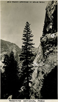 McCarthy Album 10, Photograph 290
 Caption: "Big trees growing in solid rock. Yosemite National Park," c. 1935.
-
 McCarthy Album 10, Photograph 289
 No Caption: A birds-eye view of the granite mountains in Yosemite National Park.
-
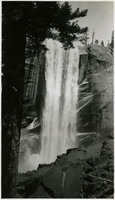
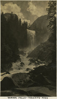
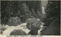 McCarthy Album 10, Photograph 288
 Caption: "Vernal Falls [sic]- Yosemite National Park," c. 1935. A view of Vernal Fall at Yosemite National Park.
-
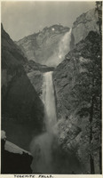 McCarthy Album 10, Photograph 287
 Caption: "Yosemite Falls," c. 1935.
-
 McCarthy Album 10, Photograph 286
 No Caption: In this 1935 photograph, the opening of the Wawona highway tunnel frames the Yosemite Valley with El Capitan (the Captain) on the left, Bridalveil Falls on the right, and Half Dome in the distance.
-
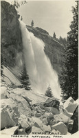 McCarthy Album 10, Photograph 285
 Caption: "Nevada Falls, Yosemite National Park," c. 1935.
-
 McCarthy Album 10, Photograph 284
 Caption: "Vernal Falls [sic]- Yosemite Park," c. 1935. A view of Vernal fall at Yosemite National Park.
-
 McCarthy Album 10, Photograph 283
 No Caption: A view of Half Dome at Yosemite National Park, c. 1935.
-
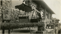 McCarthy Album 10, Photograph 282
 No Caption: Grace McCarthy seated on the veranda of the Highlands Inn, which opened in 1917 at Carmel-by-the-Sea, in Monterey County, c. 1935.
-
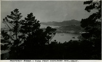 McCarthy Album 10, Photograph 281
 Caption: "Monterey Shore. - View from Highlands Inn, Calif.," c. 1935.
-
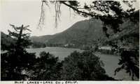 McCarthy Album 10, Photograph 280
 Caption: "Blue Lakes - Lake Co., Calif.," c. 1935.
-
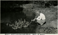 McCarthy Album 10, Photograph 279
 Caption: "Beauty Camp - Laytonville, Calif. Isn't it ducky? Flock of wild ducks being fed," c. 1935, shows William McCarthy feeding a flock of wild ducks.
-
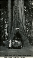 McCarthy Album 10, Photograph 278
 Caption: "The Coolidge Redwood Tree. Redwood Highway, Calif.," c. 1935. William and Grace pose with their automobile at the Coolidge Redwood Tree on the Redwood Highway in Mendocino County, named after Col. John Coolidge, father of President Calvin Coolidge.
-
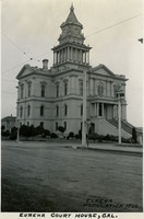 McCarthy Album 10, Photograph 277
 Caption: Eureka Court House, CAL. Eureka Population 1500," c. 1935. The Eureka County Courthouse was completed in 1889 (Curtis and Bennett, architects) in the Italianate style. The building survived several fires and earthquakes with some damage. It was condemned in 1956 and subsequently demolished to build a new, more modern facility.
-
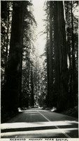 McCarthy Album 10, Photograph 276
 Caption: "Redwood Highway near Scotia," c. 1935.
-
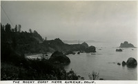 McCarthy Album 10, Photograph 275
 Caption: "The Rocky Coast near Eureka, Calif.," c. 1935.
-
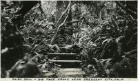 McCarthy Album 10, Photograph 274
 Caption: "Fairy Dell - Big Tree Grove near Crescent City, Calif.," c. 1935.
-
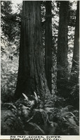 McCarthy Album 10, Photograph 273
 Caption: "Big Tree, General Custer - near Crescent City, Cal.," c.1935.
-
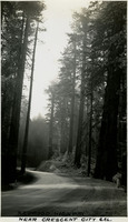 McCarthy Album 10, Photograph 272
 Caption: "Redwood Highway near Crescent City," c. 1935. U.S. Route 101, or the Redwood Highway as it is known in northern California, was established in 1926. It is also known as El Camino Real (The Royal Road) along the southern and central California Coast and approximates the old trail that linked the missions, pueblos, and presidios of the Spanish era.
-
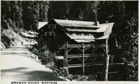 McCarthy Album 10, Photograph 271
 Caption: "Oregon Caves Chateau," c. 1935. The Oregon Caves National Monument was established in 1909. The Oregon Caves Chateau, built in the rustic style (Gust Lium, architect), opened in 1934. It is listed on the National Register of Historic Places and is a National Historic Landmark.
-
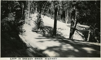 McCarthy Album 10, Photograph 270
 Caption: "Loop in Oregon Caves Highway," c. 1935.
-
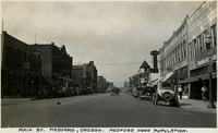 McCarthy Album 10, Photograph 269
 Caption: "Main St. Medford, Oregon. Medford 11000 Population," c. 1935.
-
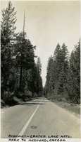 McCarthy Album 10, Photograph 268
 Caption: "Highway - Crater Lake Natl. Park to Medford, Oregon," c. 1935.
-
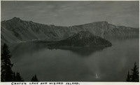 McCarthy Album 10, Photograph 267
 Caption: "Crater Lake and Wizard Island," c. 1935.
-
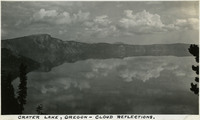 McCarthy Album 10, Photograph 266
 Caption: "Crater Lake, Oregon - cloud reflections," c. 1935.
-
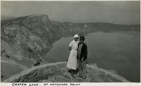 McCarthy Album 10, Photograph 265
 Caption: "Crater Lake, At Watchman Point," c. 1935, shows Grace and William McCarthy at Watchman Point, overlooking Crater Lake.
-
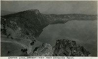 McCarthy Album 10, Photograph 264
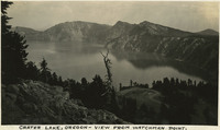
 Caption: "Crater Lake, Oregon - View from Watchman Point," c. 1935. Located in the Crater Lake National Park, Crater Lake is a caldera lake formed about 7,700 years ago by the collapse of the volcano, Mount Mazama. Its 1,949 foot depth makes it the deepest lake in U.S.
-
 McCarthy Album 10, Photograph 263
 Caption: Snow Tunnel on Crater Lake Trail to Watchman Point," c. 1935, shows Grace McCarthy standing on the trail.
-
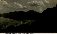 McCarthy Album 10, Photograph 262
 Caption: "Crater Lake - View from the Lodge," c. 1935, shows clouds and sky reflected in the lake. Located in the Crater Lake National Park, Crater Lake is a caldera lake formed about 7,700 years ago by the collapse of the volcano, Mount Mazama. Its 1,949 foot depth makes it the deepest lake in the United States.
-
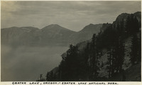 McCarthy Album 10, Photograph 261
 Caption: "Crater Lake, Oregon - Crater Lake National Park," c. 1935. Located in the Crater Lake National Park, Crater Lake is a caldera lake formed about 7,700 years ago by the collapse of the volcano, Mount Mazama. Its 1,949 foot depth makes it the deepest lake in the United States.
-
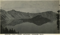 McCarthy Album 10, Photograph 260
 Caption: "Crater Lake - Arrow indicates Watchman Point," c. 1935. Located in the Crater Lake National Park, Crater Lake is a caldera lake formed about 7,700 years ago by the collapse of the volcano, Mount Mazama. Its 1,949 foot depth makes it the deepest lake in the United States.
-
 McCarthy Album 10, Photograph 259
 Caption: "Crater Lake, Oregon - View from Watchman Point," c. 1935. Located in the Crater Lake National Park, Crater Lake is a caldera lake formed about 7,700 years ago by the collapse of the volcano, Mount Mazama. Its 1,949 foot depth makes it the deepest lake in the United States.
-
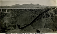 McCarthy Album 10, Photograph 258
 Caption: "Crooked River Canyon, 26 Miles from Bend, Oregon," c. 1935.