-
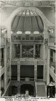 McCarthy Album 10, Photograph 399
 Caption: Palace of Fine Arts, Interior beautiful marble effect - Mexico City." Pictured is the interior of the Palace of Fine Arts in Mexico City, with the famous mural, Man at the Crossroads, painted by Mexican artist Diego Rivera. The work was originally commissioned for New York's Rockefeller Center in 1933 but was destroyed for its perceived anti-capitalist themes. Rivera recreated it for the Palace of Fine Arts in 1934.
-
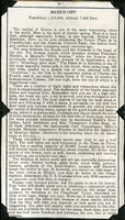
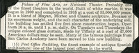 McCarthy Album 10, Photograph 398
 No Caption: A section of an informational tourist brochure describing the Palace of Fine Arts, or National Theater in Mexico City.
-
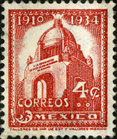 McCarthy Album 10, Photograph 397b
 No Caption: A four-cent Mexican postage stamp.
-
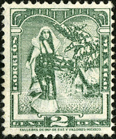 McCarthy Album 10, Photograph 397a
 No Caption: A two-cent Mexican postage stamp.
-
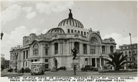 McCarthy Album 10, Photograph 397
 Caption: "Palace of Fine Arts or National Theater [sic] - built of white marble. Work started in 1900, complete in 1935, cost 35,000,000 pesos." The Palacio de Bellas Artes, is considered the cultural center of Mexico City. It houses the Museum of Architecture, and the National Theater, a performance space for music, dance, and theatre. Murals by renown Mexican artists such as Diego Rivera, Rufino Tamayo, Jose Clemente Orozco, and others are exhibited on the top floor and other galleries throughout the building.
-
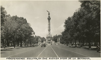 McCarthy Album 10, Photograph 396
 Caption: "Independence column, on the Avenida Paseo de la Reforma." Unofficially known as El Angel (The Angel), and officially as Monumento a la Indenpendencia (Monument to Independence), located in Mexico City.
-
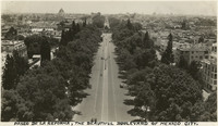 McCarthy Album 10, Photograph 395
 Caption: "Paseo de La Reforma, the beautiful boulevard of Mexico City."
-
 McCarthy Album 10, Photograph 394
 No Caption: A page from an informational tourist brochure describing Mexico City.
-
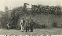 McCarthy Album 10, Photograph 393
 Caption: "In our flower decked tourist court, 46 Neva St. Mexico City." Grace McCarthy is seen sitting on an automobile bumper in the background of this photograph, while three Mexican men wearing sombreros and serapes pose in the foreground.
-
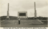 McCarthy Album 10, Photograph 392
 Caption: "Pan-American Highway monument marking the highway completion, July 1, 1936 Altitude 8209 feet. Highest point on route - 15 miles south of Octopan [sic], Mexico." Pictured is William McCarthy standing before the "Monument of Good Friendship (El Monumento de Buena Amistad), near Actopan, Mexico.
-
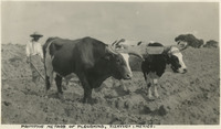 McCarthy Album 10, Photograph 391
 Caption: "Primitive method of ploughing, Tizayuca, Mexico."
-
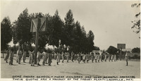 McCarthy Album 10, Photograph 390
 Caption: "Otme [sic] Indian School - these children are very scantily dressed. Their clothes are a product of the Maguey plant - Lagunilla, Mex."
-
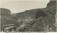 McCarthy Album 10, Photograph 389
 Caption: "Tasquillo Canyon - Rio Tula, in vicinity of Zimipan, Mexico."
-
 McCarthy Album 10, Photograph 388
 Caption: "Maguey, a most useful plant from which is made paper, rope, twine, cloth, vinegar, molases [sic], medicine and native drinks, pulque, mezcal & tequila."
-
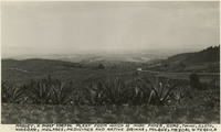
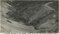 McCarthy Album 10, Photograph 387
 Caption: "Winding highway in the Sierra Madre Oriental mountains - Zimipan, Mexico."
-
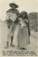 McCarthy Album 10, Photograph 386
 Caption: "Old Otomie [sic]Indian lady and her son. She is spinning twine from Maguey fiber onto a spool as she trudges the highway barefooted, Zimipan, Mexico."
-
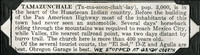
 McCarthy Album 10, Photograph 385
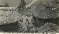
 Caption: "Thatched hut Indian village, near Tamazunchale, Mexico."
-
 McCarthy Album 10, Photograph 384
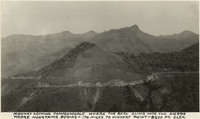
 Caption: "Highway leaving Tamazunchale where the real climb into the Sierra Madre mountains begins - 170 miles to highest point - 8200 ft. elevation."
-
 McCarthy Album 10, Photograph 383
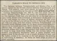
 No Caption: A section of a tourist brochure describing the route and road conditions from Tamazunchale to Mexico City.
-
 McCarthy Album 10, Photograph 382
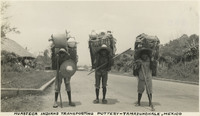
 Caption: "Huasteca Indians transporting pottery - Tamazunchale, Mexico."
-
McCarthy Album 10, Photograph 381
Caption: "Huasteca Indian and their thatched hut, one tiny room. Tamzunchale, Mexico." **PLEASE NOTE: The electronic image derived from Album 10, Photograph 381 of the William McCarthy Photograph Collection (96-07-08-alb10-381) contains content that may not be appropriate for online distribution, and has therefore been withheld. The image has also been removed from the Secretary of State’s digital storage systems, including hard drives, shared drives, cloud and other online storage, and digital backup systems. To view the original photograph, please contact the California State Archives Reference Desk.
-
McCarthy Album 10, Photograph 380
Caption: "Little girls who live in Mexico are always fully clothed but, this is not a little girl. OH! OH!" Image of a young boy in a small Mexican village. **PLEASE NOTE: The electronic image derived from Album 10, Photograph 380 of the William McCarthy Photograph Collection (96-07-08-alb10-380) contains content that may not be appropriate for online distribution, and has therefore been withheld. The image has also been removed from the Secretary of State’s digital storage systems, including hard drives, shared drives, cloud and other online storage, and digital backup systems. To view the original photograph, please contact the California State Archives Reference Desk.
-
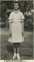 McCarthy Album 10, Photograph 379
 Caption: "Hermoso [sic] Dorothy Gandy. A youthful Mexican beauty."
-
 McCarthy Album 10, Photograph 378a
 Caption: "We stopped at Gandy Courts." A section of a tourist informational brochure describing the village of Tamazunchale, in "the heart of the Huastecan Indian country."
-
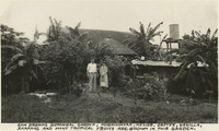 McCarthy Album 10, Photograph 378
 Caption: "Sam Browns [sic] botanical garden, Huichihuayan, Mexico. Coffee, vanilla, bananas, and many tropical fruits are grown in this garden."
-
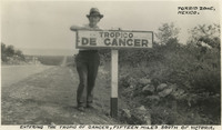 McCarthy Album 10, Photograph 377
 Caption: "Entering the Tropic of Cancer, fifteen miles south of Victoria, Torrid Zone, Mexico," shows William McCarthy standing beside a sign reading: Tropico de Cancer.
-
 McCarthy Album 10, Photograph 376
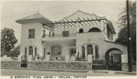
 Caption: "A Spanish type home - Valles, Mexico."
-
 McCarthy Album 10, Photograph 375
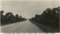
 Caption: "A natural palm grove on the highway near Villa Juarez, Mexico."
-
 McCarthy Album 10, Photograph 374b
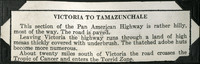
 No Caption: A section of a tourist informational brochure describing the Pan American Highway from Victoria to Tamazunchale.
-
 McCarthy Album 10, Photograph 374a
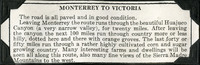
 No Caption: A section of a tourist informational brochure describing the road from Monterrey to Victoria.
-
McCarthy Album 10, Photograph 374
Caption: "Mexican home and family - Bozo, near Monterey [sic], Mexico." Six children of the Bozo family standing outside their home near Monterrey. ** PLEASE NOTE: The electronic image derived from Album 10, Photograph 374 of the William McCarthy Photograph Collection (96-07-08-alb10-374) contains content that may not be appropriate for online distribution, and has therefore been withheld. The image has also been removed from the Secretary of State’s digital storage systems, including hard drives, shared drives, cloud and other online storage, and digital backup systems. To view the original photograph, please contact the California State Archives Reference Desk.
-
 McCarthy Album 10, Photograph 373
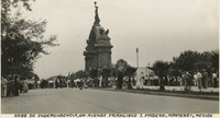
 Caption: "Arco de Independencia, on Avenda [sic] Francisco I. Madero, Monterey [sic], Mexico," shows the Arco de Independencia (Arch of independence) on Avenida (Avenue) Francisco I. Madero, in Monterrey, Mexico.
-
 McCarthy Album 10, Photograph 372
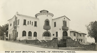
 Caption: "One of the many beautiful homes, in Monterey [sic], Mexico."
-
 McCarthy Album 10, Photograph 371
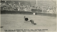
 Caption: "The bull charging while the Matador stands motionless. Bull fight - Monterey [sic], Mexico."
-
 McCarthy Album 10, Photograph 370
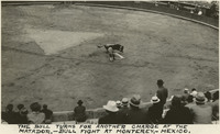
 Caption: "The bull turns for another charge at the Matador. Bull fight at Monterey [sic], Mexico."
-
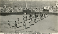 McCarthy Album 10, Photograph 369
 Caption: "Bull Fight, Monterey [sic] Mexico. Cuadrillas entering the arena - Matadores Garcia and Ramirez."
-
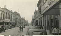 McCarthy Album 10, Photograph 368
 Caption: "Avenda [sic] Morelos, Monterey [sic], Mexico," shows a busy street scene on Avenida (Avenue) Morelos, Monterrey, Mexico.
-
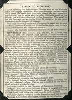 McCarthy Album 10, Photograph 367
 No Caption: A page from a tourist brochure detailing how to travel from Laredo to Monterrey, Mexico.
-
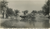 McCarthy Album 10, Photograph 366
 Caption: "Indians crude way of obtaining water for home use - Vallecillo, Mexico," 1938, shows a Mexican man in an oxen-driven cart filling a pail with water from a river, while three boys watch from the shore in Vallecillo, Mexico.
-
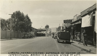 McCarthy Album 10, Photograph 365
 Caption: "Laredo, Texas - Highway entrance to Mexico at International bridge - U.S. Customs office on left. April 12, 1938."
-
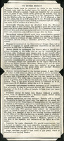
 McCarthy Album 10, Photograph 364
 No Caption: A page from a tourist brochure detailing information about Mexico, including agriculture, forestry, and mining and oil production.
-
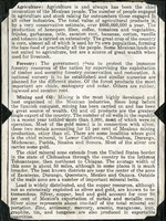
 McCarthy Album 10, Photograph 363
 No Caption: A page from a tourist brochure detailing travel information for tourists to Mexico, including automobile permits, money exchange, baggage inspection, accident insurance, firearms, hunting, registration for cameras, furs, and diamonds, and "Negro servants," which "require a cash bond of 250 pesos, which is refunded upon leaving Mexico."
-
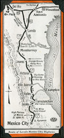 McCarthy Album 10, Photograph 362
 No Caption: A map of the highway from Laredo to Mexico City.
-
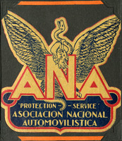 McCarthy Album 10, Photograph 361a
 No Caption: A "ANA Asociacion Nacional Automovilistica 'Protection - Service," decal in yellow, red, and blue, with the Mexican symbol of an eagle holding a serpent in its beak and talons, based on the Aztec symbol that represented the founding of the city, Tenochtitlan, today Mexico City.
-
 McCarthy Album 10, Photograph 361
 No Caption: A page from a tourist brochure with information about Mexico re: total area in square miles, topography, population, and climate.
-
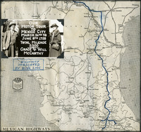 McCarthy Album 10, Photograph 360
 Caption: "Our Motor Tour to Mexico City March 26th to June 8th 1938. Total Mileage 5,500, Grace & Will McCarthy. Highway indicated by Blue Line," written on a map of Mexico, with a photograph of William and Grace McCarthy next to a large sign detailing their tour of Mexico as described above.
-
 McCarthy Album 10, Photograph 359b
 No Caption: An American Express Travel Bureau brochure in red, yellow, and green, and titled: The Way to See Mexico, from The Emporium travel agency in San Francisco. c. 1938.
-
 McCarthy Album 10, Photograph 359a
 No Caption: A "Mexico by Motor" decal, c. 1938, rectangular, in yellow and purple.
-
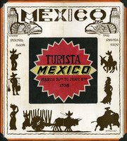 McCarthy Album 10, Photograph 359
 Caption: "Turista - Mexico - March 26th to June 8th, 1938," handwritten on a Mexico tourist brochure indicating the McCarthys' trip to Mexico in 1938. The brochure itself reads: Mexico - Visit Fiesta Land the Fiesta Way."
-
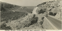 McCarthy Album 10, Photograph 358
 Caption: "Pacos [sic] River - View from Del Rio Highway, Texas." c. 1935. Pecos River and Del Rio Highway, Texas.