-
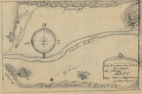
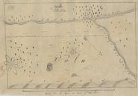
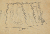
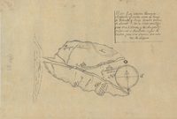
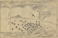
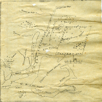
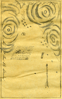
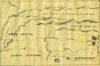
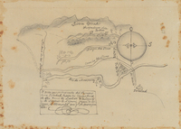 Punta del Monte, or Rincon de la Monte or Rincon del la Punta de Monte de la Soledad Rancho
 Hand-drawn sketch map of Punta del Monte, or Rincon de la Monte, or Rincon del la Punta de Monte de la Soledad boundaries. Volume 1, page 140.
-
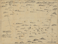
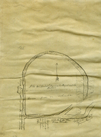
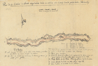
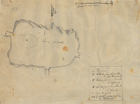
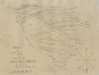
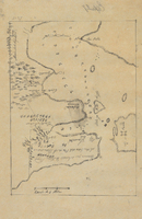
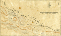
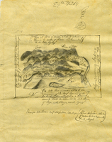
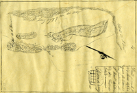
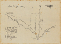 Cajon de Santa Ana Rancho
 Hand-drawn sketch map of Cajon de Santa Ana. Volume 1, page 138.
-
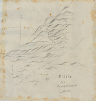
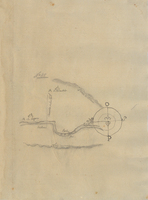
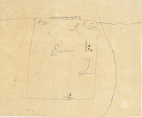
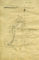
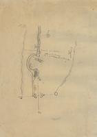
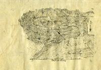
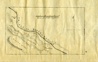
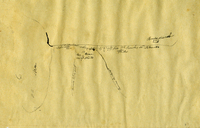
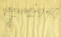
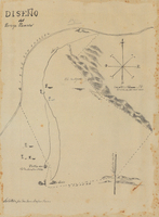 Paso de Bartolo, Viejo Rancho
 Hand-drawn sketch map of Paso de Bartolo, Viejo. Volume 1, page 132.
-
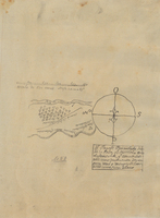
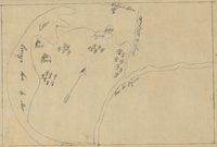
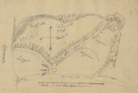
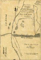
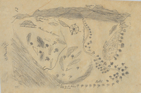
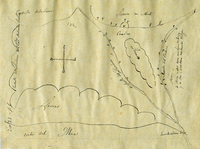
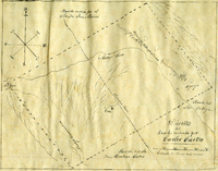
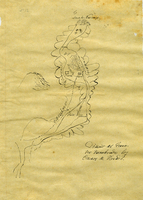
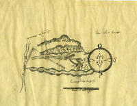
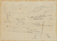 Melijo Rancho
 Hand-drawn sketch map of Melijo boundaries. Volume 1, Page 130.
-
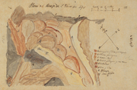
 Corral de Tierra Rancho
 Hand-drawn sketch map of Corral de Tierra boundaries. Volume 1, page 128.
-
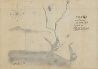 Alamitos Rancho
 Hand-drawn stech map of Alamitos boundaries. Volume 1, page 122.
-
 Alamitos Rancho
 Hand-drawn stech map of Alamitos boundaries. Volume 1, page 117.
-
 Pescadero Rancho
 Hand-drawn sketch map of Pescadero boundaries. Volume 1, page 116.
-
 Santa Anita Rancho
 Hand-drawn sketch map of Santa Anita boundaries. Volume 1, page 114.
-
 Las Virgenes Rancho
 Hand-drawn sketch map of las Virgenes boundaries. Volume 1, page 109.
-
 Las Virgenes Rancho
 Hand-drawn sketch map of las Virgenes boundaries. Volume 1, page 110..
-
 PilarcitosRancho
 Hand- drawn sketch map of Pilarcitos boundaries. Volume 1, page 108.
-
 Ajajoljol Rancho
 Hand- drawn sketch map of Ajajoljol boundaries. Volume 1, page 106.
-
 San Mateo or Saucito Rancho
 Hand-drawn sketch map of San Mateo or Saucito boundaries. Volume 1, page 102.
-
 Arroyo del Infesto Rancho
 Hand-drawn sketch map of Arroyo del Infesto boundaries. Volume 1, page 8.
-
 Monterey River Rancho
 Hand-drawn sketch map of Monterey River boundaries. Volume 1, page 96.
-
 Bolsa de los Rodrigues or Bolsa del Pajaro Rancho
 Hand-drawn sketch map of Bolsa de los Rodrigues or Bolsa del Pajaro boundaries. Volume 1, page 94.
-
 Pala Rancho
 Hand-drawn sketch map of Pala boundaries. Volume 1, page 92.
-
 Tecate Rancho
 Hand-drawn sketch map of Tecate boundaries. Volume 1, page 89.
-
 Pilarcitos or Las Pilarcitos Rancho
 Hand-drawn sketch map of Pilarcitos or Las Pilarcitos boundaries. Volume 1, page 88.
-
 Punta de Cipress or Punta de Sepreses Rancho
 Hand-drawn sketch map of Punta de Cipress or Punta de Sepreses boundaries. Volume 1, page 84.
-
 San Pedro Rancho
 Hand-drawn sketch map of San Pedro boundaries. Volume 1, page 82.
-
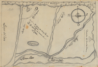
 Temecula Rancho
 Hand-drawn sketch map of Temecula boundaries. Volume 1, page 80.
-
 Punta de Pinos Rancho
 Hand-drawn sketch map of Punta de Pinos boundaries. Volume 1, page 76.
-
 Arroyo de las Nueces y Bolbones or San Miguel Rancho
 Hand-drawn sketch map of Arroyo de las Nueces y Bolbones or San Miguel boundaries. Volume 1, page 74.
-
 Acalanes Rancho
 Hand-drawn sketch map of Acalanes boundaries. Volume 1, page 72.
-
 Sur or El Sur Rancho
 Hand-drawn sketch map of Sur or El Sur boundaries. Volume 1, page 68.
-
 Land in Nacional Rancho
 Hand-drawn sketch map of Land in Nacional boundaries. Volume 1, page 66.
-
 Nacional Rancho
 Hand-drawn sketch map of Nacional boundaries. Volume 1, page 64.
-
 Meganos Rancho
 Hand-drawn sketch map of Meganos boundaries. Volume 1, page 62.
-
 Ojo de Agua de la Coche Rancho
 Hand-drawn sketch map of Ojo de Agua de la Coche boundaries. Volume 1, page 60.
-
 Carte de Madera del Presidio or San Clemente Rancho
 Hand-drawn sketch map of Carte de Madera del Presidio or San Clemente boundaries. Volume 1, page 56.
-
 Nipomo Rancho
 Hand-drawn sketch map of Nipomo boundaries. Volume 1, page 54.
-
 Pescadero or San Antonio Rancho
 Hand-drawn sketch map of Pescadero or San Antonio boundaries. Volume 1, page 52.
-
 Rio Ojotska or Rio del Sacramento Rancho
 Hand-drawn sketch map of Rio Ojotska or Rio del Sacramento boundaries. Volume 1, page 50.
-
 Llamitos de los Correos or Guadalupe y Llamitos de los Correos or Chular Rancho
 Hand-drawn sketch map of Llamitos de los Correos or Guadalupe y Llamitos de los Correos or Chular boundaries. Volume 1, page 48.
-
 Llajome or Yajome Rancho
 Hand-drawn sketch map of Llajome or Yajome boundaries. Volume 1, page 46.
-
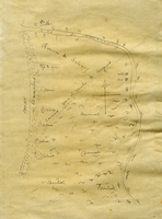
 San Francisco de las Llagas Rancho
 Hand-drawn sketch map of San Francisco de las Llagas boundaries. Volume 1, page 42.
-
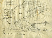 Former lands of Mission Delores, or San Pablo, or Cuchiosmos, or Cuchiguenos, or Cuduyunes Rancho
 Hand-drawn sketch map of Former lands of Mission Delores, or San Pablo, or Cuchiosmos, or Cuchiguenos, or Cuduyunes boundaries. Volume 1, page 40.
-
 Former lands of Mission Delores, or San Pablo, or Cuchiosmos, or Cuchiguenos, or Cuduyunes Rancho
 Hand-drawn sketch map of Former lands of Mission Delores, or San Pablo, or Cuchiosmos, or Cuchiguenos, or Cuduyunes boundaries. Volume 1, page 38.
-
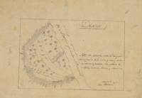
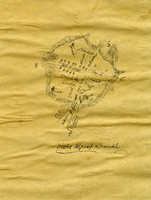 Jamacha, or Jamacho Rancho
 Hand-drawn sketch map of Jamacha, or Jamacho boundaries. Volume 1, page 36.
-
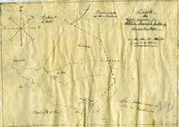
 Rincon de las Salinas Rancho
 Hand- drawn sketch map of Rincon de las Salinas boundaries. Volume 1, page 34.
-
 Corral de Tierra Rancho
 Hand-drawn sketch map of Corral de Tierra boundaries. Volume 1, page 32.
-
 Guadalasca (Guadalagsa) Rancho
 Hand-drawn sketch map of Guadalasca (Guasalagsa) boundaries. Volume 1, page 30.
-
 Escarpin, or Las Salinas or El Tucho Rancho
 Hand-drawn sketch map of Escarpin, or Las Salinas or El Tucho boundaries. Volume 1, page 26.
-
 Cueras de Venado Rancho
 Hand-drawn sketch map of Cueras de Venado boundaries. Volume 1, page 24.
-
 Las Posas Rancho
 Hand-drawn sketch map of Posas boundaries. Volume 1, page 22.
-
 Laguna de la Merced Rancho
 Hand-drawn sketch map of Laguna de la Merced boundaries. Volume 1, page 20.
-
 Nuestra Senora del Refugio Rancho
 Hand-drawn sketch map of Nuestra Senora del Refugio boundaries. Volume 1, page 18.
-
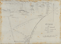
 El Toro Rancho
 Hand-drawn sketch map of Toro boundaries. Volume 1, page 14.