Items
Search full-text
Duncan McMillan Registered Sex Offender Simi Valley Lewd Acts with a Minor
-
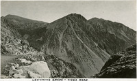 McCarthy Album 04, Photograph 049 Caption: "Leevining [sic] Grade -- Tioga Road." The Lee Vining Grade is on the eastern side of Tioga Pass in the Sierra Nevada Mountains in Mono County, California, northeast of Yosemite Valley. It constitutes part of the Tioga Road, or Tioga Pass Road, now part of California State Route 120. The Grade is visible in the photograph as a thin line running along the mountain sides in the lower third of the image.
 -
 Old Series Trademark No. 1175 Bear Valley
 -
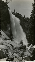
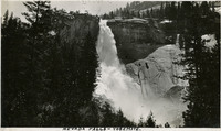 McCarthy Album 09, Photograph 248 Caption: "Nevada Falls [sic]," c. 1917. Nevada Fall is a 594-foot high waterfall upstream of Vernal Fall on the Merced River, in the Little Yosemite Valley.
 -
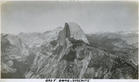 McCarthy Album 09, Photograph 249 Caption: "Half Dome - Yosemite," c. 1917. The iconic granite Half Dome rises above the Yosemite Valley. This photograph appears to have been taken from a neighboring peak.
 -
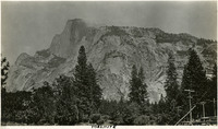 McCarthy Album 09, Photograph 250 Caption: "Yosemite," c. 1917. Yosemite's iconic Half Dome, a granite rock formation, as seen from the valley floor.
 -
 Old Series Trademark No. 0321 San Joaquin Valley Mills, Stockton City Mills, Sperry's Mills
 -
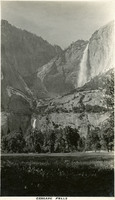
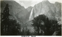 McCarthy Album 09, Photograph 251 Caption: "Yosemite Falls," c.1917. Both the Upper and Lower Yosemite Falls, on Yosemite Creek, are visible in this photograph, taken from the valley floor. The highest waterfall in Yosemite National Park, Yosemite Falls is made up of two successive cascades falling a total of 2,425 feet from the top of the Upper Fall to the base of the Lower Fall. The Upper Fall alone is 1,430 feet high, and is one of the top twenty highest waterfalls in the world.
 -
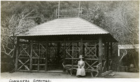 McCarthy Album 05, Photograph 108 Caption: "Congress Springs.," c. 1910. Grace McCarthy seated on an unusual bench made from a tree branch and logs, in front of a timber shelter at Pacific Congress Springs near Saratoga in California's Santa Clara Valley. Pacific Congress Springs, a mineral spring named after Congress Springs in New York, operated as a resort area from the nineteenth century until the 1930s.
 -
 Old Series Trademark No. 1034 Manzanita, Manzanita Water
 -
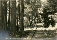
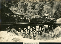 McCarthy Album 06, Photograph 180 Caption: "Tamalpais R.R." c. 1907. A view of the Muir Woods Railway, established in 1896 as a scenic tourist railway between Mill Valley and the east peak of Mount Tamalpais in Marin County.
 -
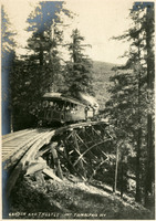 McCarthy Album 06, Photograph 181 Caption: "Canyon and Trestle Mt Tamalpais RR.," c. 1907. Muir Woods Railway, established in 1896 as a scenic tourist railway between Mill Valley and the east peak of Mount Tamalpais in Marin County.
 -
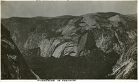 McCarthy Album 09, Photograph 258 Caption: "Mountains in Yosemite," c. 1917. View of rock cliffs and domes in the mountains surrounding Yosemite Valley.
 -
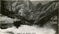 McCarthy Album 09, Photograph 261 Caption: "Summit of Nevada Falls [sic]," c. 1917. View from the top of Nevada Fall into Yosemite Valley.
 -
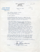 Correspondence on Potential Incarceration Camp Correspondence from Geo. J. Overholt to Earl Warren regarding potential internment of Japanese at Secret Valley
 -
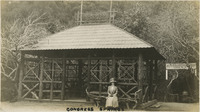 McCarthy Album 07, Photograph 195 Caption: "Congress Springs.", c. 1910. Grace McCarthy seated on an unusual bench made from a tree branch and logs, in front of a timber shelter at Pacific Congress Springs, near Saratoga in California's Santa Clara Valley. Pacific Congress Springs, a mineral spring named after Congress Springs in New York, operated as a resort area from the nineteenth century until the 1930s. See also 96-07-08-alb05-108.
 -
 Old Series Trademark No. 3214 C.V.C.A. monogram
 -
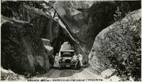 McCarthy Album 09, Photograph 266 Caption: "Arched Rock- Merced River Drive - Yosemite.," c. 1917. Grace and William McCarthy (to right of the car) pose with their vehicle and an unidentified woman underneath the arched rock on what is now Highway 140, the El Portal Road. The area is now known as the Arched Rock Entrance to Yosemite Valley.
 -
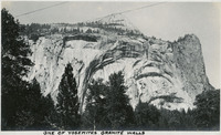 McCarthy Album 09, Photograph 268 Caption: "One of Yosemite's Granite Walls," c. 1917. View of a granite wall carved by glaciers and shaped by water, wind, and rock falls, in the Yosemite Valley.
 -
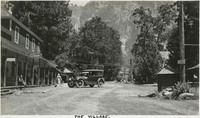 McCarthy Album 09, Photograph 269 Caption: "The Village," c. 1917. Street scene in the Yosemite Village, the most developed part of the Yosemite Valley. The Village is home to such amenities as a Post Office, store, medical clinic, fire station, and restaurants. Development began at the site in 1865, but most of the buildings were constructed after 1918.
 -
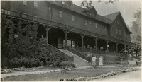
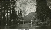 McCarthy Album 09, Photograph 270 Caption: "Sentinel Hotel," c. 1917. The Sentinel Hotel at Yosemite Village, with a granite cliff in the background and the Merced River in the foreground. Construction of the hotel began in 1876, and at the turn of the century it was the only hotel operating in the valley. Increased attendance as the twentieth century progressed resulted in the construction of other tourist areas such as Curry Village, and the Sentinel gradually became obsolete. The Sentinel and the complex of buildings that had grown up around it were torn down in the late 1930s.
 -
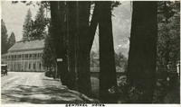 McCarthy Album 09, Photograph 271 Caption: "Sentinel Hotel," c. 1917. The Sentinel Hotel at Yosemite Village. Construction of this hotel began in 1876, and at the turn of the century it was the only hotel operating in the valley. Increased attendance as the twentieth century progressed resulted in the construction of other tourist areas such as Curry Village, and the Sentinel gradually became obsolete. The Sentinel and the complex of buildings that had grown up around it were torn down in the late 1930s.
 -
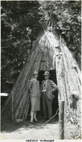
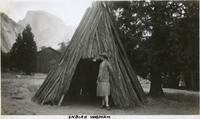 McCarthy Album 09, Photograph 272 Caption: "Indian Wigwam," c. 1917. Grace McCarthy poses at the entrance to what William McCarthy labeled a "wigwam," a dwelling of the Ahwahnechee people. The Ahwahnechee (a Native American tribe who traditionally occupied the Yosemite Valley) called the dwellings o-chum. Pine branches were arranged in a tee-pee-like shape and then covered with layered slabs of cedar bark.
 -
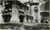 McCarthy Album 09, Photograph 274 No caption. William McCarthy stands in front of the Ahwahnee Hotel in Yosemite National Park, c. 1935. Opened in 1927 and designed by architect Gilbert Stanley Underwood, the Ahwahnee Hotel is located on the floor of Yosemite Valley. It was built as a resort hotel by the Yosemite Park and Curry Company. Modernized over the years, its name was changed to the Majestic Yosemite Hotel in 2016, as a result of legal dispute over trademarked names in the park.
 -
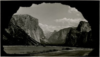 McCarthy Album 10, Photograph 286 No Caption: In this 1935 photograph, the opening of the Wawona highway tunnel frames the Yosemite Valley with El Capitan (the Captain) on the left, Bridalveil Falls on the right, and Half Dome in the distance.
 -
 McCarthy Album 09, Photograph 278 Caption: "El Portal," c. 1917. Grace McCarthy poses with two unidentified people in front of the Hotel del Portal (or Del Portal Hotel) in El Portal, California. The resort hotel was constructed in 1908 by the Yosemite Terminal Company, a subsidiary of the Yosemite Valley Railroad Company, to provide accommodations for visitors to the park who arrived by train. The hotel burned to the ground in late October of 1917.
 -
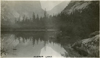 McCarthy Album 09, Photograph 281 Caption: "Mirror Lake," c. 1917. Mirror Lake in Yosemite National Park, on Tenaya Creek, is the remains of a glacial lake that used to fill most of the valley. Its calm waters provide near-perfect reflections of the surrounding natural splendor.
 -
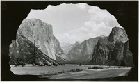 McCarthy Album 10, Photograph 291 No Caption: In this 1935 photograph, the opening of the Wawona highway tunnel frames the Yosemite Valley with El Capitan (the Captain) on the left, Bridalveil Falls on the right, and Half Dome in the distance.
 -
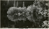 McCarthy Album 09, Photograph 282 Caption: "Mirror Lake," c. 1917. Mirror Lake in Yosemite National Park, on Tenaya Creek, is the remains of a glacial lake that used to fill most of the valley. Its calm waters provide near-perfect reflections of the surrounding natural splendor.
 -
 Old Series Trademark No. 2401 Mikado
 -
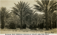 McCarthy Album 10, Photograph 042 Caption: "Shields Date Gardens - Coachella Valley, Blythe, Calif. May 31, 1935." Date Palms at the Shields Date Gardens, which opened in 1924 at Blythe, California.
 -
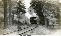 McCarthy Album 05, Photograph 016 Caption: "In Muir Woods.," c. 1906. Grace McCarthy (in hat with white feather) and an unidentified woman standing at a small platform along a railroad in Muir Woods, being passed by a train car. This was likely part of the Mount Tamalpais and Muir Woods Railway, established in 1896 as a scenic tourist railway between Mill Valley and the east peak of Mt. Tamalpais in Marin County. See also 96-07-08-alb05-017.
 -
 Old Series Trademark No. 2930 Valley Queen
 -
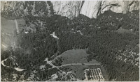 McCarthy Album 10, Photograph 301 No Caption: A birds-eye view of Yosemite Valley with the Merced River running through it, c. 1935.
 -
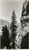 McCarthy Album 09, Photograph 293 Caption: " Rugged Cliffs," c. 1917. View of a sheer cliff face with rocky, timbered mountains beyond.
 -
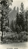 McCarthy Album 09, Photograph 294 Caption: "Cathedral Spires," c. 1917. Rock formation known as Cathedral Spires in Yosemite National Park, as seen from the valley floor through trees.
 -
 Old Series Trademark No. 1081 N.V.W. Co.
 -
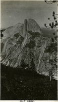 McCarthy Album 09, Photograph 295 Caption: "Half Dome," c. 1917. The iconic granite Half Dome rises above the Yosemite Valley in this photograph, taken from a neighboring peak.
 -
 Old Series Trademark No. 1336 Ursin's Pile Cure
 -
 McCarthy Album 06, Photograph 222 Caption: "Entering The Redwoods, Mt Tamalpais RR," c. 1907. A view of the Muir Woods Railway tracks, established in 1896 as a scenic tourist railway between Mill Valley and the east peak of Mount Tamalpais in Marin County.
 -
 Old Series Trademark No. 1337 Sunbeam, Ruby Valley, Morning Glory, Assembly, Criterion
 -
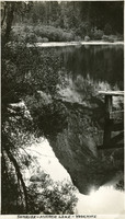
 McCarthy Album 09, Photograph 300 Caption: "Nevada Falls [sic] - Yosemite," c. 1917. Nevada Fall is a 594-foot high waterfall upstream of Vernal Fall on the Merced River, in the Little Yosemite Valley. This photograph, taken at a point next to the fall's path of descent, shows the upper portion of the fall.
 -
 Old Series Trademark No. 2764 Valley Queen
 -
 Old Series Trademark No. 2406 The Electric Slimer Company
 -
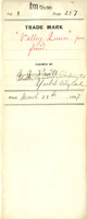
 Old Series Trademark No. 2765 Valley Lily Soap
 -
 McCarthy Album 09, Photograph 304 Caption: "Cascade Falls," c. 1917. Erroneously labeled as Cascade Falls, this photograph actually shows both the Upper and Lower Yosemite Falls as viewed from the floor of Yosemite Valley. The highest waterfall in Yosemite National Park, Yosemite Falls is made up of two successive cascades falling a total of 2,425 feet from the top of the Upper Fall to the base of the Lower Fall. The Upper Fall alone is 1,430 feet high, and is one of the top twenty highest waterfalls in the world.
 -
 McCarthy Album 09, Photograph 305 Caption: "Sunrise - Mirror Lake - Yosemite," c. 1917. A reflection of a sunrise on Mirror Lake. The lake, fed by Tenaya Creek, is the remains of a glacial lake that used to fill most of the valley. Its calm waters provide near-perfect reflections of the surrounding natural splendor.
 -
 McCarthy Album 09, Photograph 306 Caption: "Indian Wigwam," c. 1935. William and Grace McCarthy pose at the entrance to what William labeled a "wigwam," a dwelling of the Ahwahnechee people. The Ahwahnechee (a Native American tribe who traditionally occupied the Yosemite Valley) called the dwellings o-chum. Pine branches were arranged in a tee-pee-like shape and then covered with layered slabs of cedar bark.
 -
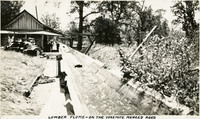 McCarthy Album 04, Photograph 236 Caption: "Lumber Flume -- on the Yosemite Merced Road," c. 1920. Flume with boards being carried by running water, likely along what is now known as California State Route 140, connecting the town of Merced with the Yosemite Valley.
 -
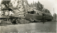 McCarthy Album 05, Photograph 036 Caption: "Wreck on the Vallejo Napa Line." Photograph showing some of the train cars involved in a June 19, 1913 accident in which two trains of the San Francisco, Napa Valley and Calistoga Railroad collided head-on approximately 2.4 miles north of Vallejo. Ten passengers and three railroad employees were killed, and twenty-eight others injured.
 -
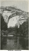 McCarthy Album 09, Photograph 308 Caption: "Granite Formation," c. 1917. A granite wall towers above the Merced River in this photograph of a portion of the Yosemite Valley.