Items
Search full-text
Duncan McMillan Registered Sex Offender Simi Valley Lewd Acts with a Minor
-
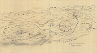 San Jose de Garcia y Simi or Simi Rancho Hand-drawn sketch map of San Jose de Garcia y Simi or Simi boundaries. Volume 1, page 704.
 -
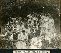 McCarthy Album 06, Photograph 136 Caption: "Green Valley Falls Picnic, "c. 1908. A large group of unidentified people pose for a photograph at Green Valley Falls near Benicia, in Solano County.
 -
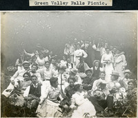 McCarthy Album 06, Photograph 137 Caption: "Green Valley Falls Picnic," c. 1908. A large group of unidentified people pose for a photograph at Green Valley Falls near Benicia in Solano County.
 -
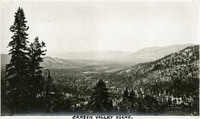 McCarthy Album 04, Photograph 040 Caption: "Carson Valley Scene." Valley surrounded by mountains.
 -
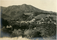 McCarthy Album 06, Photograph 220 Caption: "Mt Tamalpais from Mill Valley," c. 1907 shows a bird's eye view of Mount Tamalpais and the valley below.
 -
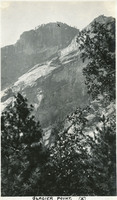 McCarthy Album 09, Photograph 307 Caption: "Glacier Point (x)," c. 1917. In this photograph of the walls of Yosemite Valley, taken from the valley floor, William McCarthy has marked the location of Glacier Point with an "x." Glacier Point, on the south wall of the valley 3,200 feet above what is now known as Half Dome Village, provides panoramic views of the valley and many of its features.
 -
 Old Series Trademark No. 0156 Turner's Essence of Jamaica Ginger
 -
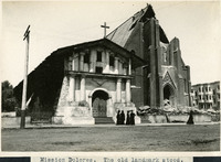 McCarthy Album 08, Photograph 189 Caption: "Mission Dolores. The old landmark stood." View of Mission San Francisco de Asís, also known as Mission Dolores. Dedicated in 1791, the adobe mission survived the 1906 earthquake and fire with minor damage, while the brick church right next door was destroyed.
 -
 Old Series Trademark No. 1037 Boss
 -
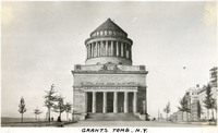 McCarthy Album 09, Photograph 158 Caption: "Grants Tomb. N.Y." The remains of Ulysses S. Grant, 18th President of the U.S. and Commanding General of the Union Army during the last year of the Civil War, were laid to rest in this elaborate tomb, designed by architect John Duncan. Grant died in 1885, but construction on the granite and marble structure did not begin until 1891. Grant's remains were transferred to the tomb on April 27, 1897. The tomb is the largest mausoleum in North America. See also 96-07-08-alb11-209.
 -
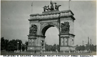 McCarthy Album 09, Photograph 164 Caption: "Soldiers and Sailors Memorial Arch - Prospect Park - Brooklyn," c. 1925. (John H. Duncan, architect) The Soldiers' and Sailors' Arch was built between 1889 and 1892, and dedicated on October 21st, 1892 to honor the "Defenders of the Union, 1861-1865."
 -
 McCarthy Album 11, Photograph 054 Caption: "Cabildo or Old Spanish Jail and St. Louis Cathedral -- New Orleans, June 16, 34." The façade of the Cabildo dominates this photograph, while the corner of St. Louis Cathedral is visible at the right. The Cabildo was the seat of government for New Orleans while the area was under Spanish jurisdiction. The building was also the site of the transfer ceremonies when the U.S. purchased the Louisiana Territory from France in 1803. Although damaged by fire in 1988, the restored Cabildo survived Hurricane Katrina in 2005 with only minor damage.
 -
 Land-valley of Temecula Rancho Hand-drawn sketch map of Land-valley of Temecula boundaries. Volume 2, page 83.
 -
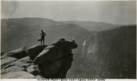 McCarthy Album 09, Photograph 260 Caption: "Glacier Point - 3000 Feet Above Camp Curry," c. 1917. William McCarthy poses atop Glacier Point, overlooking Yosemite Valley. Glacier Point, on the south wall of the valley 3,200 feet above what is now known as Half Dome Village, provides panoramic views of the valley and many of its features.
 -
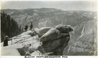
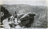 McCarthy Album 09, Photograph 279 Caption: "Glacier Point - Over Hanging Rock - Yosemite Falls In The Distance," c. 1935. A group of unidentified people looking out from Glacier Point. Both Upper and Lower Yosemite Fall are visible across the valley at the right side of the photograph. Glacier Point, on the south wall of the valley 3,200 feet above what is now known as Half Dome Village, provides panoramic views of the valley and many of its features. By the time this photograph was taken, safety railings had been installed at the Point to prevent visitors from tumbling over the cliff while trying to get the best views.
 -
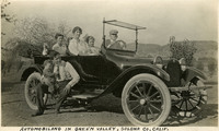 McCarthy Album 06, Photograph 252 Caption: "Automobiling in Green Valley, Solona [sic] Co, Calif," c. 1915. William McCarthy in driver's seat, and Grace McCarthy in passenger's seat, with several unidentified people in an automobile in Solano County.
 -
 Old Series Trademark No. 3271 Santa Ana Valley Walnut Grower Association
 -
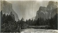 McCarthy Album 09, Photograph 243 Caption: "Yosemite.," c. 1920. View of the Yosemite Valley from the valley floor, with the Merced River in the foreground, and El Capitan (left) and the Cathedral Rocks (right) in the background. Bridalveil Fall cascades down a cliff face beneath the Cathedral Rocks.
 -
 McCarthy Album 09, Photograph 245 Caption: "Yosemite," c. 1917. View of Yosemite Valley, taken from the valley floor, with Half Dome rising at the right. .
 -
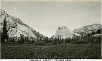 McCarthy Album 04, Photograph 057 Caption: "Mountain Scene -- Tenaya Lake." Meadow with surrounding rocks and mountains. Named after Chief Tenaya of Yosemite Valley's Ahwahnechee People, Tenaya Lake is located between Yosemite Valley and Tuolumne Meadows within Yosemite National Park. The surface elevation of the alpine lake is 8,150 feet.
 -
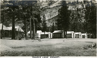 McCarthy Album 04, Photograph 058 Caption: "Tenaya Lake Resort." Small cabins in front of rocky mountainside. Named after Chief Tenaya of Yosemite Valley's Ahwahnechee People, Tenaya Lake is located between Yosemite Valley and Tuolumne Meadows within Yosemite National Park. The surface elevation of the alpine lake is 8,150 feet.
 -
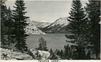
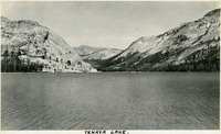 McCarthy Album 04, Photograph 059 Caption: "Tenaya Lake." Lake with surrounding mountains. Named after Chief Tenaya of Yosemite Valley's Ahwahnechee People, Tenaya Lake is located between Yosemite Valley and Tuolumne Meadows within Yosemite National Park. The surface elevation of the alpine lake is 8,150 feet.
 -
 McCarthy Album 04, Photograph 060 Caption: "Tenaya Lake." Lake with surrounding mountains. Named after Chief Tenaya of Yosemite Valley's Ahwahnechee People, Tenaya Lake is located between Yosemite Valley and Tuolumne Meadows within Yosemite National Park. The surface elevation of the alpine lake is 8,150 feet.
 -
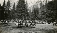 McCarthy Album 09, Photograph 263 Caption: "Potato Race - July 4, 1917." Several horseback riders holding long poles skirmish in what appears to be a game similar to polo, played with a potato. A crowd has gathered to watch the game, while the rock cliff walls of Yosemite Valley tower in the background. Given the date, this was likely part of Independence Day festivities in the Yosemite Valley.
 -
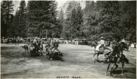 McCarthy Album 09, Photograph 264 Caption: "Potato Race," c. 1917. Several horseback riders holding long poles skirmish around a bucket in what appears to be a game similar to polo, played with a potato. A crowd has gathered to watch the game, while the rock cliff walls of Yosemite Valley tower in the background. Given the date, this was likely part of Independence Day festivities in the Yosemite Valley.
 -
 McCarthy Album 09, Photograph 273 Caption: "Half Dome," c. 1917. The iconic granite Half Dome rises above the Yosemite Valley. This photograph appears to have been taken from across the Valley.
 -
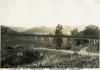 McCarthy Album 03, Photograph 091 Caption: "Santa Fe Trestle, Alhambra Valley," Martinez, Contra Costa County, California, c. 1906.
 -
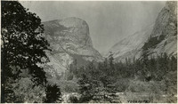
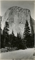 McCarthy Album 09, Photograph 296 Caption: "El Capitan," c. 1917. El Capitan is a vertical granite rock formation in Yosemite Valley. It's sheer cliff face, rising almost 3,000 feet above the Valley, is a favorite rock climbing location.
 -
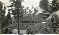 McCarthy Album 09, Photograph 317 Caption: "Glacier Point Hotel," c. 1917. The 80-room chalet-style Glacier Point Hotel opened in 1918, located 3,218 feet above the floor of Yosemite Valley on Glacier Point. This photograph shows the back side of the building, with a viewing porch that looked out over the valley. The building was destroyed by an electrical fire in July 1969.
 -
 McCarthy Album 09, Photograph 318 Caption: "Glacier Point - Overhanging Rock," c. 1935. Grace McCarthy poses for a photograph at Glacier Point's iconic overhanging rock. Glacier Point, on the south wall of the valley 3,200 feet above what is now known as Half Dome Village, provides panoramic views of the valley and many of its features. By the time this photograph was taken, safety railings had been installed at the Point to prevent visitors from tumbling over the cliff while trying to get the best views.
 -
 Old Series Trademark No. 1759 Aphroditine
 -
 Old Series Trademark No. 2570 Valley Road
 -
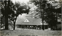 McCarthy Album 04, Photograph 136 Caption: "Hobergs Resort -- Lake Co.," c. 1920. Resort buildings nestled in grove of trees. Built in 1885, the resort stood until 2015, when it was destroyed by the Valley Fire.
 -
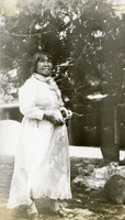 McCarthy Album 04, Photograph 264 No caption, c. 1935. Lucy Parker Telles, a Mono Lake Paiute, lived in the Yosemite Valley. She was part of a group of Native American women who became well-known for their intricate basket weaving.
 -
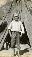 McCarthy Album 04, Photograph 265 No caption, c. 1935. Unidentified man standing in front of an Indian abode in the Yosemite Valley,
 -
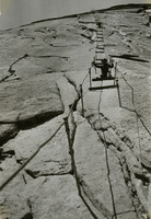 McCarthy Album 04, Photograph 266 No caption, c. 1935. William McCarthy on the steep trail to the summit of the iconic Half Dome, in the Yosemite Valley. The cables used to assist hikers follow a route laid down by George Anderson, who reached the summit in 1875.
 -
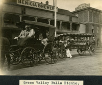 McCarthy Album 06, Photograph 138 Caption: "Green Valley Falls Picnic," c. 1908, shows an unidentified group of people riding in horse-drawn carriages in front of the Benicia Brewery building.
 -
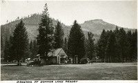 McCarthy Album 04, Photograph 015 Caption: "Grounds at Donner Lake Resort." Shows mountain valley scene with resort building and parked car.
 -
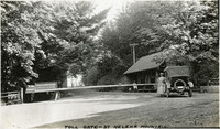 McCarthy Album 04, Photograph 142 Caption: "Toll Gate -- St Helena Mountain.," c. 1920. Toll gate consists of a long wooden spar across the road, with a small building to the right. Grace McCarthy is standing next to an automobile at the gate. The St. Helena Toll Road, now part of California State Route 29, connected the Napa Valley with Lake County. It was built in 1868, and purchased by the State of California in 1925.
 -
 Old Series Trademark No. 1312 Flower of the Valley, Elixir of Life
 -
 Old Series Trademark No. 0502 Valley Press
 -
 Old Series Trademark No. 3350 Pride of the Valley
 -
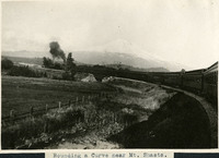 McCarthy Album 06, Photograph 279 Caption: "Rounding a Curve near Mt. Shasta," c. 1910. A view of a train rounding a curve in the valley below a snow-covered Mount Shasta, seen in the distance.
 -
 Old Series Trademark No. 3125 Pomona Valley Brand
 -
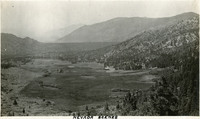 McCarthy Album 04, Photograph 039 Caption: "Nevada Scenes." Valley surrounded by mountains.
 -
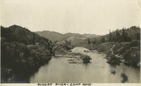 McCarthy Album 07, Photograph 299 Caption: "Russian River - Camp Rose," c. 1915, shows the Russian River and Valley at Camp Rose in Healdsburg.
 -
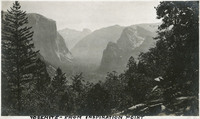 McCarthy Album 09, Photograph 244 Caption: "Yosemite - From Inspiration Point," c. 1917. The Yosemite Valley, showing El Capitan (left middle distance), Cathedral Rocks (right middle distance), and Half Dome (far distance in the center).
 -
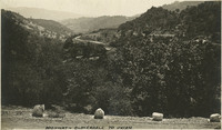 McCarthy Album 07, Photograph 304 Caption: "Highway - Cloverdale to Ukiah," c. 1915, shows a view of foothills and valley from an unidentified highway (likely U.S. 101) in Sonoma County.
 -
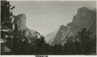
 McCarthy Album 09, Photograph 246 Caption: "Yosemite," c. 1917. View of the Yosemite Valley.
 -
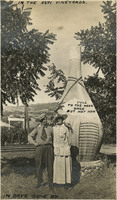 McCarthy Album 07, Photograph 306 Caption: "In The Asti Vineyards - In Days Gone By," c. 1915, shows William and Grace McCarthy posing in front of a giant sculpture of a wine bottle at the Italian Swiss Colony winery, Asti Vineyards, in the Alexander Valley in Sonoma County.