-
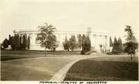 McCarthy Album 04, Photograph 082
 Caption: "Memorial -- Cemetry [sic] of Arlington," c. 1935. Shows an exterior view of Arlington Memorial Amphitheater in Arlington National Cemetery, dedicated in 1920. The Tomb of the Unknowns, also known as the Tomb of the Unknown Soldier, on the amphitheater's east steps, can be seen at the far left.
-
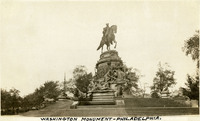 McCarthy Album 04, Photograph 081
 Caption: "Washington Monument -- Philadelphia." c. 1920. Philadelphia's Washington Monument Fountain (Rudolf Siemering, sculptor) features a bronze and granite statute of George Washington on horseback. Dedicated at Fairmount Park in 1897, it was moved to Philadelphia's Eakins Oval in 1928.
-
 McCarthy Album 04, Photograph 080
 Caption: "Old Faithful Geyser," c. 1920. Eruption of Old Faithful, a cone geyser in Yellowstone National Park.
-
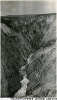 McCarthy Album 04, Photograph 079
 Caption: "Yellowstone Grand Canyon," c. 1920s. Overview of first large canyon along Yellowstone River below Yellowstone Falls, in Yellowstone National Park.
-
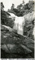 McCarthy Album 04, Photograph 078
 Caption: "Seven Falls -- Colorado Springs," c. 1920. One of a series of seven waterfalls on South Cheyenne Creek near Colorado Springs, Colorado.
-
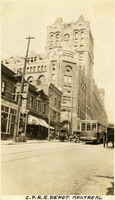 McCarthy Album 04, Photograph 077
 Caption: "C.P.R.R. Depot. Montreal," c. 1920. Street scene dominated by Canadian Pacific Railway depot building, built in 1889. The tower was added in 1916.
-
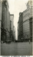 McCarthy Album 04, Photograph 076
 *Caption: "Broadway at Bowling Green, N.Y." Street scene in New York City, showing Broadway near the small public park Bowling Green. See also 96-07-08-alb11-233 and 96-07-08-alb09-204.
-
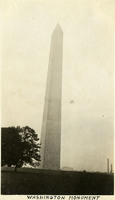 McCarthy Album 04, Photograph 075
 Caption: "Washington Monument," c. 1920. Built between 1848 and 1888 to commemorate George Washington (former Commander-in-Chief of the Continental Army and first President of the United States), the obelisk is the world's tallest stone structure at a height of 555 feet. See also 96-07-08-alb09-212.
-
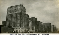 McCarthy Album 04, Photograph 074
 Caption: "Blackstone Hotel -- Michigan Av. Chicago," c. 1923. Built in 1909 and designed by Benjamin Marshall, the twenty-one story Blackstone Hotel sits on the corner of Michigan Avenue and Balbo Drive in Chicago Illinois. It is the building closest to the left side of the photograph in this row of high-rises. See also 96-07-08-alb09-092.
-
 McCarthy Album 04, Photograph 073a
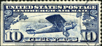
 No caption. This commemorative ten-cent stamp was affixed to the same page as Photographs 073 and 074. With "United States Postage, Lindbergh Air Mail" written across the top, it shows the biplane Spirit of St. Louis, over a drawing of the Atlantic Ocean between New York and Paris. Issued in June 1927 as a tribute to Charles Lindbergh, who made the first non-stop flight between Paris and New York in May of that year.
-
 McCarthy Album 04, Photograph 073
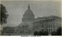
 Caption: "Capitol -- Wash. D.C." c. 1920. Shows the U.S. Capitol Building (dome and both wings, at oblique angle). Originally constructed in 1800, the building has undergone several expansions, including the addition of the wedding-cake-style dome in the 1850s.
-
 McCarthy Album 04, Photograph 072
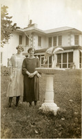
 No caption. Grace McCarthy and an unidentified woman posing beside large bird bath or fountain, in front of the John Shields residence, in the Daybreak Estate area of Long Island.
-
 McCarthy Album 04, Photograph 071
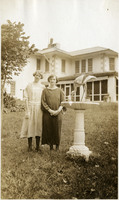
 No caption. Grace McCarthy and an unidentified woman posing beside large bird bath or fountain, in front of the John Shields residence, in the Daybreak Estate area of Long Island. See also 96-07-08-alb09-208 and 96-07-08-alb11-230.
-
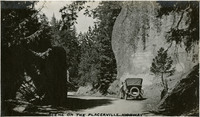
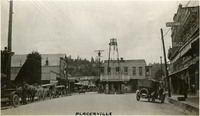 McCarthy Album 04, Photograph 070
 Caption: "Placerville," c. 1920. Street scene in Placerville. Automobiles mix with horses and wagons along the curbs.
-
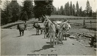 McCarthy Album 04, Photograph 069
 Caption: "Mountain Pack Burros," c. 1920. String of burros loaded with packs, with fields and trees in background. One young, unburdened burro stands off to the left of the main group.
-
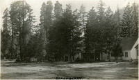 McCarthy Album 04, Photograph 068
 Caption: "Strawberry," c. 1920. Small buildings nestled among trees, with automobiles parked at left.
-
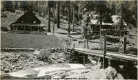 McCarthy Album 04, Photograph 067
 Caption: "Scene on the American River," c. 1920. Narrow bridge over river, leading to two houses, with sign stating "3. F. Rancho. 1915."
-
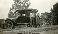 McCarthy Album 04, Photograph 066
 Caption: "Bullion Bend Monument," c. 1920. William and Grace McCarthy standing in front of an automobile, near a stone monument. Bullion Bend, located between Pollock Pines and Whitehall in the historic Highway 50 corridor, was the scene of a stagecoach robbery in 1864 in which silver bullion was stolen by robbers claiming to need the money in order to support the Confederate Army.
-
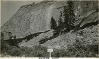 McCarthy Album 04, Photograph 065
 Caption: "Lovers Leap." This rock formation consists of a band of granite cliffs rising above the Eldorado National Forest.
-
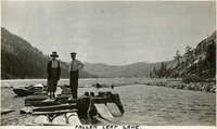 McCarthy Album 04, Photograph 064
 Caption: "Fallen Leaf Lake." Grace and William McCarthy standing on wood plank dock, with lake and mountains in background.
-
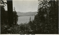 McCarthy Album 04, Photograph 063
 Caption: "Fallen Leaf Lake." Lake seen through trees on a hillside.
-
 McCarthy Album 04, Photograph 062
 Caption: "Scene on the Placerville Highway." Grace McCarthy standing near an automobile on the side of an unpaved road, today's U.S. Route 50, east of Placerville.
-
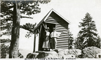 McCarthy Album 04, Photograph 061
 Caption: "Summit -- Tahoe, Placerville Highway." William and Grace McCarthy standing in front of a small wood shed, likely along what is now U.S. Route 50 east of Placerville.
-
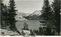 McCarthy Album 04, Photograph 060
 Caption: "Tenaya Lake." Lake with surrounding mountains. Named after Chief Tenaya of Yosemite Valley's Ahwahnechee People, Tenaya Lake is located between Yosemite Valley and Tuolumne Meadows within Yosemite National Park. The surface elevation of the alpine lake is 8,150 feet.
-
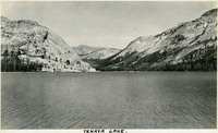 McCarthy Album 04, Photograph 059
 Caption: "Tenaya Lake." Lake with surrounding mountains. Named after Chief Tenaya of Yosemite Valley's Ahwahnechee People, Tenaya Lake is located between Yosemite Valley and Tuolumne Meadows within Yosemite National Park. The surface elevation of the alpine lake is 8,150 feet.
-
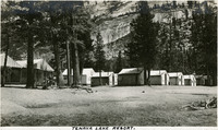 McCarthy Album 04, Photograph 058
 Caption: "Tenaya Lake Resort." Small cabins in front of rocky mountainside. Named after Chief Tenaya of Yosemite Valley's Ahwahnechee People, Tenaya Lake is located between Yosemite Valley and Tuolumne Meadows within Yosemite National Park. The surface elevation of the alpine lake is 8,150 feet.
-
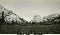 McCarthy Album 04, Photograph 057
 Caption: "Mountain Scene -- Tenaya Lake." Meadow with surrounding rocks and mountains. Named after Chief Tenaya of Yosemite Valley's Ahwahnechee People, Tenaya Lake is located between Yosemite Valley and Tuolumne Meadows within Yosemite National Park. The surface elevation of the alpine lake is 8,150 feet.
-
 McCarthy Album 04, Photograph 056
 Caption: "Tioga Lake." Glacial lake in the Sierra Nevada Mountains, in Mono County, California, within the Inyo National Forest.
-
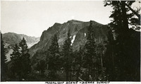 McCarthy Album 04, Photograph 055
 Caption: "Moonlight Scene -- Sierra Summit." Rocky crag in the Sierra Nevada Mountains.
-
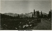 McCarthy Album 04, Photograph 054
 Caption: "Tuolumne Meadows." Meadow area along the Tuolumne River in the eastern portion of Yosemite National Park, with mountains in the background. Tuolumne Meadows is recognized as one of the largest alpine meadows of the Sierra Nevada Mountains.
-
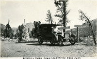 McCarthy Album 04, Photograph 053
 Caption: "Summit -- Tioga Pass -- Elevation 9940 feet." Grace McCarthy standing beside automobile on an unpaved road, near a stone monument declaring the elevation of Tioga Pass and road signs providing directions and distances to other locales.
-
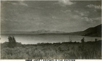 McCarthy Album 04, Photograph 052
 Caption: "Mono Lake -- Craters in the Distance." Mono Lake, in Mono County, California, is a shallow saline lake used as a resting stop by almost two million migratory birds each year.
-
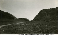 McCarthy Album 04, Photograph 051
 Caption: "Devils Gate -- Nevada -- Elevation 7540 Feet." Devil's Gate is a rock formation near Silver City, Nevada. In the nineteenth century a portion of the formation was blasted away to create enough space for a wagon road, which became a toll road serving as an entryway to the Nevada silver fields.
-
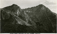 McCarthy Album 04, Photograph 050
 Caption: "Tioga Road Scenes on the Sierra Summit." Two mountain peaks as seen from the Tioga Road.
-
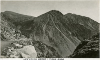 McCarthy Album 04, Photograph 049
 Caption: "Leevining [sic] Grade -- Tioga Road." The Lee Vining Grade is on the eastern side of Tioga Pass in the Sierra Nevada Mountains in Mono County, California, northeast of Yosemite Valley. It constitutes part of the Tioga Road, or Tioga Pass Road, now part of California State Route 120. The Grade is visible in the photograph as a thin line running along the mountain sides in the lower third of the image.
-
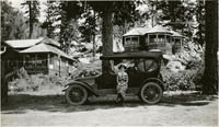 McCarthy Album 04, Photograph 048
 No caption, c. 1927. Grace McCarthy seated on the running board of an automobile parked at a resort in the Sierra Nevada Mountains, near the California-Nevada border.
-
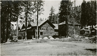 McCarthy Album 04, Photograph 047
 No caption, c. 1927. A resort in the Sierra Nevada Mountains, near the California-Nevada border.
-
 McCarthy Album 04, Photograph 046
 Caption: "Kingsbury Grade -- Nevada." Shows a hairpin turn on the Kingsbury Grade in Douglas County, Nevada. Now part of Nevada State Route 207, the road intersects U.S. Highway 50 near the southeastern corner of Lake Tahoe.
-
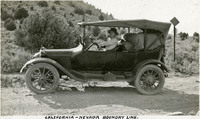 McCarthy Album 04, Photograph 045
 Caption: "California-Nevada Boundary Line." Grace McCarthy in driver's seat of automobile, on unpaved road with hillside in the background.
-
 McCarthy Album 04, Photograph 044
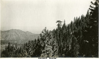
 Caption: "Nevada Scene." Mountainside, with another mountain in the distance.
-
 McCarthy Album 04, Photograph 043
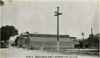
 Caption: "State Penitentiary -- Carson City Nevada." View of prison gate and some of the buildings.
-
 McCarthy Album 04, Photograph 042
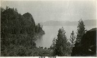
 Caption: "Lake Tahoe."
-
 McCarthy Album 04, Photograph 041
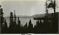
 Caption: "Lake Tahoe."
-
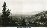 McCarthy Album 04, Photograph 040
 Caption: "Carson Valley Scene." Valley surrounded by mountains.
-
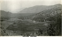 McCarthy Album 04, Photograph 039
 Caption: "Nevada Scenes." Valley surrounded by mountains.
-
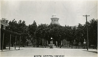 McCarthy Album 04, Photograph 038
 Caption: "State Capitol -- Nevada." Dome of Nevada's Neoclassical Italianate State Capitol Building, constructed between 1869 and 1871 in Carson City. Trees obscure much of the building.
-
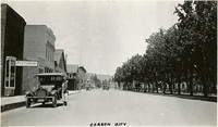 McCarthy Album 04, Photograph 037
 Caption: "Carson City." Street scene with Grace McCarthy standing next to an automobile.
-
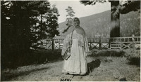 McCarthy Album 04, Photograph 036
 Caption: "Mary." Elderly woman with shawl and metal pail standing in front of fence.
-
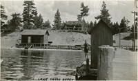 McCarthy Album 04, Photograph 035
 Caption: "Lake Tahoe Beach." Beach scene, with William McCarthy standing on dock.
-
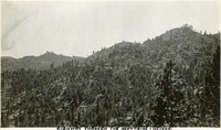 McCarthy Album 04, Photograph 034
 Caption: "Highway through the Mountains -- Nevada." Mountain scene, with highway snaking through trees in the distance.