-
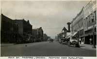 McCarthy Album 10, Photograph 269
 Caption: "Main St. Medford, Oregon. Medford 11000 Population," c. 1935.
-
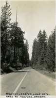 McCarthy Album 10, Photograph 268
 Caption: "Highway - Crater Lake Natl. Park to Medford, Oregon," c. 1935.
-
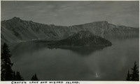 McCarthy Album 10, Photograph 267
 Caption: "Crater Lake and Wizard Island," c. 1935.
-
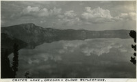 McCarthy Album 10, Photograph 266
 Caption: "Crater Lake, Oregon - cloud reflections," c. 1935.
-
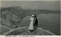 McCarthy Album 10, Photograph 265
 Caption: "Crater Lake, At Watchman Point," c. 1935, shows Grace and William McCarthy at Watchman Point, overlooking Crater Lake.
-
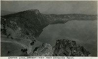 McCarthy Album 10, Photograph 264
 Caption: "Crater Lake, Oregon - View from Watchman Point," c. 1935. Located in the Crater Lake National Park, Crater Lake is a caldera lake formed about 7,700 years ago by the collapse of the volcano, Mount Mazama. Its 1,949 foot depth makes it the deepest lake in U.S.
-
 McCarthy Album 10, Photograph 263
 Caption: Snow Tunnel on Crater Lake Trail to Watchman Point," c. 1935, shows Grace McCarthy standing on the trail.
-
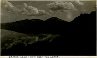 McCarthy Album 10, Photograph 262
 Caption: "Crater Lake - View from the Lodge," c. 1935, shows clouds and sky reflected in the lake. Located in the Crater Lake National Park, Crater Lake is a caldera lake formed about 7,700 years ago by the collapse of the volcano, Mount Mazama. Its 1,949 foot depth makes it the deepest lake in the United States.
-
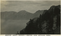 McCarthy Album 10, Photograph 261
 Caption: "Crater Lake, Oregon - Crater Lake National Park," c. 1935. Located in the Crater Lake National Park, Crater Lake is a caldera lake formed about 7,700 years ago by the collapse of the volcano, Mount Mazama. Its 1,949 foot depth makes it the deepest lake in the United States.
-
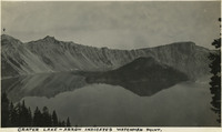 McCarthy Album 10, Photograph 260
 Caption: "Crater Lake - Arrow indicates Watchman Point," c. 1935. Located in the Crater Lake National Park, Crater Lake is a caldera lake formed about 7,700 years ago by the collapse of the volcano, Mount Mazama. Its 1,949 foot depth makes it the deepest lake in the United States.
-
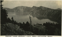 McCarthy Album 10, Photograph 259
 Caption: "Crater Lake, Oregon - View from Watchman Point," c. 1935. Located in the Crater Lake National Park, Crater Lake is a caldera lake formed about 7,700 years ago by the collapse of the volcano, Mount Mazama. Its 1,949 foot depth makes it the deepest lake in the United States.
-
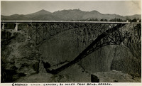 McCarthy Album 10, Photograph 258
 Caption: "Crooked River Canyon, 26 Miles from Bend, Oregon," c. 1935.
-
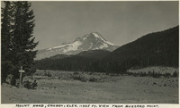 McCarthy Album 10, Photograph 257
 Caption: "Mount Hood, Oregon, Elev. 11225 ft. View from Buzzard Point," c. 1935. Mount Hood is a potentially active volcano in the Cascade Volcanic Arc of the Cascade Range in the Clackamas and Hood River counties of northern Oregon. The last eruption of Mount Hood was in 1907.
-
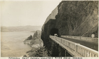 McCarthy Album 10, Photograph 256
 Caption: "Mitchell Point Tunnel - Columbia River Drive, Oregon," c. 1935.
-
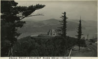 McCarthy Album 10, Photograph 255
 Caption: "Crown Point - Columbia River Drive - Oregon," c. 1935.
-
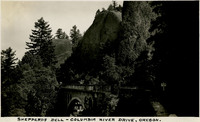 McCarthy Album 10, Photograph 254
 Caption: "Shepperd's Dell - Columbia River Drive, Oregon," c. 1935.
-
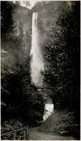
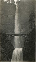
 McCarthy Album 10, Photograph 253
 Caption: Multnomah Falls, Columbia River Highway, Oregon," c. 1935.
-
 McCarthy Album 10, Photograph 252
 Caption: "Bonneville Dam under construction - Columbia River, Oregon," c. 1935. Construction on the dam and first powerhouse began in 1934.
-
 McCarthy Album 10, Photograph 251
 Caption: "Bonneville, Columbia River Dam Headquarters, Oregon," c. 1935.
-
 McCarthy Album 10, Photograph 250
 No Caption: A view of the Multnomah Falls on the Oregon side of the Columbia River, c. 1935.
-
 McCarthy Album 10, Photograph 249
 No Caption: A view from the Multnomah Fall Bridge over the Columbia River, c. 1935.
-
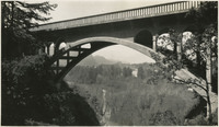
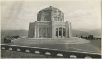 McCarthy Album 10, Photograph 248
 No Caption: Vista House at Crown Point along the historic Columbia River Highway in Multnomah County, Oregon, c. 1935.
-
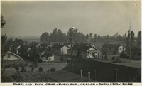 McCarthy Album 10, Photograph 247
 Caption: "Portland Auto Camp - Portland, Oregon - Population 310,000." c. 1935.
-
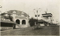 McCarthy Album 10, Photograph 246
 No Caption: See also 96-07-08-alb05-185, with caption: "Council Crest -- Portland," Buildings and benches in a park setting, with a tall observation tower, labeled the "Observatory," at the right side of the photograph. Council Crest Park in Portland, Oregon was the site of an amusement park between 1907 and 1929. The buildings in this photograph were part of that park. The Observatory, built in 1907, was demolished in 1941 to make room for a water tower. The area is still in use as a municipal park.
-
 McCarthy Album 10, Photograph 245
 No Caption: A view of the Multnomah Falls on the Oregon side of the Columbia River, c. 1935.
-
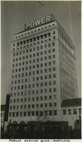 McCarthy Album 10, Photograph 244
 Caption: "Public Service Bldg.- Portland," c. 1935.
-
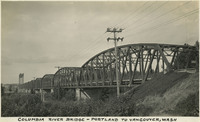 McCarthy Album 10, Photograph 243
 Caption: "Columbia River Bridge - Portland to Vancouver, Washington," c. 1935.
-
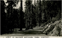 McCarthy Album 10, Photograph 242
 Caption: "Loop in Rainier National Park Highway," c. 1935.
-
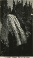 McCarthy Album 10, Photograph 241
 Caption: "Narada Falls, Rainier Park," c. 1935.
-
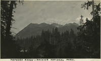 McCarthy Album 10, Photograph 240
 Caption: "Tatoosh Range - Rainier National Park," c. 1935.
-
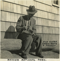 McCarthy Album 10, Photograph 239
 Caption: "The Clark Crow gets a peanut. Rainier National Park," c. 1935, shows William McCarthy feeding a Clark Crow.
-
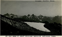 McCarthy Album 10, Photograph 238
 Caption: "Tatoosh Mountain Range. At the base of Mount Rainier - Rainier National Park," c. 1935.
-
 McCarthy Album 10, Photograph 237
 Caption: "Nisqually Glacier, Mount Rainier - Note the ice on slope slowly breaking up," c, 1935.
-
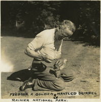 McCarthy Album 10, Photograph 236
 Caption: "Feeding a Golden Mantled Squirrel Rainier National Park," c. 1935, shows William McCarthy feeding the wildlife at Mt. Rainier National Park.
-
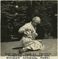 McCarthy Album 10, Photograph 235
 Caption: "The Golden Mantled Squirrel reaching for another nut. Rainier National Park." c. 1935, shows Grace McCarthy feeding the wildlife at Mt. Rainier National Park.
-
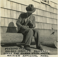 McCarthy Album 10, Photograph 234
 Caption: "Feeding the Golden Mantled Squirrel while the Clark Crow waits. Rainier National Park," c. 1935. William McCarthy is shown feeding the wildlife.
-
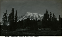 McCarthy Album 10, Photograph 233
 Caption: "Mount Rainier - Rainier National Park," c. 1935, shows glaciers on the 14,410 foot mountain. An iconic landmark on the Washington landscape, Mt. Rainier is an active volcano.
-
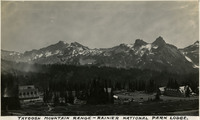 McCarthy Album 10, Photograph 232
 Caption: "Tatoosh Mountain Range - Rainier National Park Lodge," c. 1935.
-
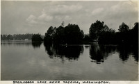 McCarthy Album 10, Photograph 231
 Caption: "Steilacoom Lake Near Tacoma, Washington," c. 1935.
-
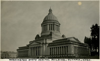 McCarthy Album 10, Photograph 230
 Caption: "Washington State Capitol Building, Olympia, Wash." c. 1935. The Neo-classical style building (Walter R. Wilder and Harry K. White, architects) opened in 1928, and was listed on the National Register of Historic Places in 1979.
-
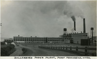 McCarthy Album 10, Photograph 229
 Caption: "Zellerbach Paper Plant, Port Townsend, Wash." c. 1935. The Crown Zellerbach National Paper Products Mill in Port Townsend opened in 1928.
-
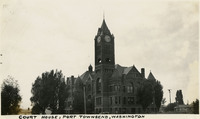 McCarthy Album 10, Photograph 228
 Caption: "Court House, Port Townsend, Washington," c. 1935. The Jefferson County Courthouse in Port Townsend, Washington, was built in 1891 (W.A. Ritchie, architect) in Romanesque architectural style.
-
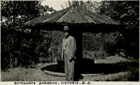 McCarthy Album 10, Photograph 227
 Caption: "Butcharts Gardens, Victoria, B.C." c. 1935, shows William McCarthy standing in the gardens.
-
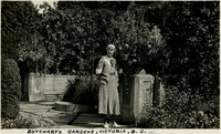 McCarthy Album 10, Photograph 226
 Caption: "Butcharts Gardens, Victoria, B.C." c. 1935, shows Grace McCarthy standing in the gardens.
-
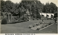
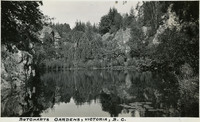 McCarthy Album 10, Photograph 225
 Caption: "Butcharts Gardens, Victoria, B.C." c. 1935.
-
 McCarthy Album 10, Photograph 224
 Caption: "Butcharts Gardens, Victoria, B.C." c. 1935.
-
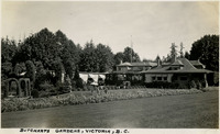 McCarthy Album 10, Photograph 223
 Caption: "Butcharts Gardens, Victoria, B.C." c. 1935.
-
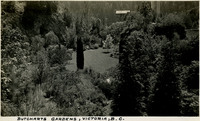 McCarthy Album 10, Photograph 222
 Caption: "Butcharts Gardens, Victoria, B.C." c. 1935.
-
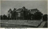 McCarthy Album 10, Photograph 221
 Caption: "Empress Hotel, Victoria, B.C." c. 1935. Built between 1904 and 1908 (Francis Rattenbury, architect), in Beaux-Arts architectural style, the Empress Hotel is located in Victoria on Vancouver Island, British Columbia. The luxury hotel was designated a National Historic Site of Canada in 1981.
-
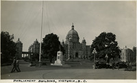 McCarthy Album 10, Photograph 220
 Caption: "Parliament Building, Victoria, B.C." c. 1935. Constructed in the Neo-baroque, Renaissance Revival and Romanesque Revival architectural style (Francis Rattenbury, architect), the British Columbia Parliament Buildings were completed in 1897, and are home to the Legislative Assembly of British Columbia.