-
 McCarthy Album 05, Photograph 275
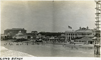
 Caption: "Long Beach," c. 1910. View of The Pike, an amusement zone along the beach front in Long Beach. The framework for the Bisby's Spiral Airship ride can be seen at the far right of the photograph.
-
 McCarthy Album 05, Photograph 274
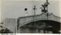
 Caption: "Venice, Calif," c. 1911. Unidentified woman standing on a bridge over Lion Canal in Venice, California. In 1905, Abbot Kinney built a series of canals as part of a development project along Santa Monica Beach, hoping to recreate the look and feel of Italy's iconic "Floating City" in southern California. Called Ocean Park at first, gondoliers sailed boats under elegant bridges such as the one shown in this photograph, in an effort to attract businesses, residents, and investors. In 1911, the name officially changed to Venice. By 1929, however, many of the canals had been filled in to create roadways, and those canals that remained fell into disrepair. A revitalization movement in the early 1990s has restored some of the canals, and made the area a desirable residential neighborhood.
-
 McCarthy Album 05, Photograph 273
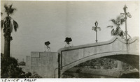
 Caption: "Venice, Calif," c. 1911. Grace McCarthy and an unidentified woman standing on a bridge over Lion Canal in Venice, California. In 1905, Abbot Kinney built a series of canals as part of a development project along Santa Monica Beach, hoping to recreate the look and feel of Italy's iconic "Floating City" in southern California. Called Ocean Park at first, gondoliers sailed boats under elegant bridges such as the one shown in this photograph, in an effort to attract businesses, residents, and investors. In 1911, the name officially changed to Venice. By 1929, however, many of the canals had been filled in to create roadways, and those canals that remained fell into disrepair. A revitalization movement in the early 1990s has restored some of the canals, and made the area a desirable residential neighborhood.
-
 McCarthy Album 05, Photograph 272
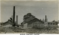
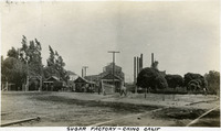
 Caption: "Sugar Factory -- Chino," c. 1915. View of Chino's sugar beet factory, established in 1891 by Robert and Henry Oxnard. Henry later established a larger factory in the town that now bears his name (Oxnard, in Ventura County). The factory operated for more than twenty-five years before closing in October 1917.
-
 McCarthy Album 05, Photograph 271
 Caption: "Sugar Factory -- Chino Calif," c. 1915. Chino's sugar beet factory, shown in this photograph, was established in 1891 by Robert and Henry Oxnard. Henry later established a larger factory in the town that now bears his name (Oxnard, in Ventura County). The Chino factory operated for more than twenty-five years before closing in October 1917.
-
 McCarthy Album 05, Photograph 270
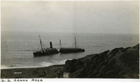
 Caption: "S.S. Santa Rosa." Wreck of the S.S. Santa Rosa off Point Arguello in Santa Barbara County. The steamship ran aground on July 6, 1911. Unable to break free, the turbulent waters eventually cracked the ship in half. All two hundred passengers got to shore alive, the only fatalities coming when four sailors were accidentally thrown out of a lifeboat by rough seas while attempting to establish a land line to stabilize the wreck.
-
 McCarthy Album 05, Photograph 269
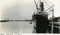
 Caption: "San Pedro Harbor," c. 1910. View of San Pedro Bay, with harbor facilities such as wharves and cranes in the background. San Pedro Bay was declared the official port for Los Angeles in 1897.
-
 McCarthy Album 05, Photograph 268
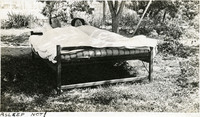
 Caption: "Asleep NOT!" William and Grace McCarthy jokingly ensconced in a bed beneath a tree in a garden or yard.
-
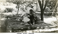
 McCarthy Album 05, Photograph 267
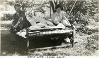
 Caption: "Camp Life -- Chino Calif." William and Grace McCarthy laughing as they remove their shoes in preparation for getting into a bed situated under a tree in a yard or garden.
-
 McCarthy Album 05, Photograph 266
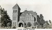
 Caption: "Chino Public School." View of public school building in Chino, California.
-
 McCarthy Album 05, Photograph 265
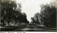
 Caption: "Chino Avenue, Chino Cal." Rural dirt road lined with trees.
-
 McCarthy Album 05, Photograph 264
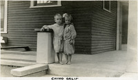
 Caption: "Chino Calif." Two unidentified children posing on the stoop of a house in Chino.
-
 McCarthy Album 05, Photograph 263
 Caption: "Camp Life -- Chino." Unidentified child and baby on bed under tree in garden or yard.
-
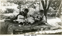 McCarthy Album 05, Photograph 262
 Caption: "Chino Calif." Four unidentified children, including a baby, playing on a bed under a tree in a yard or garden.
-
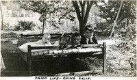 McCarthy Album 05, Photograph 261
 Caption: "Camp Life -- Chino Calif." Four unidentified children (including a baby) playing on a bed under a tree in a garden or yard.
-
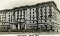 McCarthy Album 05, Photograph 260
 Caption: "Fairmount [sic] Hotel - S.F.," C. 1906. View of the Fairmont Hotel, a luxury hotel in San Francisco. Although construction was mostly finished in 1906, the advent of the San Francisco earthquake and fire of that year damaged the hotel's interior and delayed opening until 1907. It was the first hotel in what is now the Fairmont Hotels and Resorts chain. In 1945, the San Francisco hotel was host to an international conference that culminated in the formation of the United Nations.
-
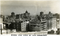 McCarthy Album 05, Photograph 259
 Caption: "Birds Eye View of San Francisco.," c. 1910. Overview of San Francisco. The dome of the Call Building can be seen in the photograph's center.
-
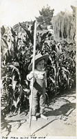 McCarthy Album 05, Photograph 258
 Caption: "The Man with the Hoe," c. 1915. Unidentified, young child posing in front of a row of corn with hoe and oversized hat.
-
 McCarthy Album 05, Photograph 256
 No caption. Two unidentified children posing on stoop of a house in Chino, California.
-
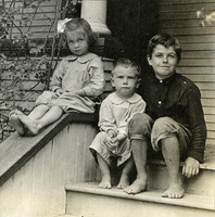 McCarthy Album 05, Photograph 255
 No caption. Three unidentified children posing on the stoop of a house in Chino, California.
-
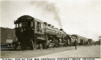 McCarthy Album 05, Photograph 254
 Caption: "S.P. Co. One of the Big Compound Engines -- Reno Nevada," c. 1910. Southern Pacific Railroad Company locomotive and accompanying rail cars in Reno, Nevada.
-
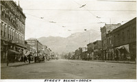 McCarthy Album 05, Photograph 253
 Caption: "Street Scene -- Ogden," c. 1916. Street scene in Ogden, Utah, with mountains in the background. Tracks and lines for electric trolleys or streetcars can be seen, as well as automobiles and several local businesses.
-
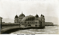
 McCarthy Album 05, Photograph 252
 Caption: "Saltair -- Salt Lake." View of the first Saltair resort pavilion and surrounding buildings. Constructed in 1893 and designed by Richard K.A. Kletting, the pavilion hovered above the Great Salt Lake on more than 2,000 posts and pilings. The resort was a popular spot for Mormon families, only fifteen miles from Salt Lake City and overseen by Church leaders. The Church sold the building in 1906. It was later destroyed by fire in 1925, but a second pavilion was quickly built.
-
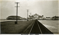
 McCarthy Album 05, Photograph 251
 Caption: "Saltair. Salt Lake." View of the first Saltair resort pavilion, constructed in 1893. Designed by Richard K.A. Kletting, the pavilion hovered above the Great Salt Lake on more than 2,000 posts and pilings. The resort was a popular spot for Mormon families, only fifteen miles from Salt Lake City and overseen by Church leaders. The Church sold the pavilion in 1906. It was later destroyed by fire in 1925.
-
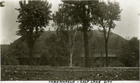 McCarthy Album 05, Photograph 250
 Caption: "Tabernacle -- Salt Lake City," c. 1916. View of the domed Salt Lake Tabernacle, built from 1864-1867. The Tabernacle housed meetings of the Church of Jesus Christ of Latter Day Saints until new facilities were constructed in 2000. The Tabernacle is home to the Mormon Tabernacle Choir, and is considered to be one of the most acoustically perfect buildings in the world due to its unique dome-shaped roof.
-
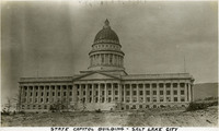 McCarthy Album 05, Photograph 249
 Caption: "State Capitol Building -- Salt Lake City," c. 1916. View of Utah's State Capitol Building, designed by Richard K.A. Kletting and built between 1912 and 1916.
-
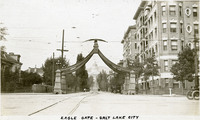 McCarthy Album 05, Photograph 248
 Caption: "Eagle Gate -- Salt Lake City," c. 1916. View of the Eagle Gate, a monument in the shape of an arch topped by an eagle with outstretched wings. The monument was originally erected in 1859 to commemorate the entrance to Brigham Young's property. The monument has been remodeled several times over the years, including a change from a carved wooden eagle to a 4,000-pound bronze eagle with twenty-foot wingspan.
-
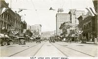 McCarthy Album 05, Photograph 247
 Caption: "Salt Lake City Street Scene.," c. 1916. Street scene in Salt Lake City, Utah. Flags and buntings suggest that the city was holding some kind of celebration at the time of the photograph. Several bicyclists appear at the photograph's right side.
-
 McCarthy Album 05, Photograph 246
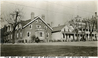
 Caption: "The Bee Hive House -- One of Brighams Houses of Several Wives." Street scene in Salt Lake City, Utah. Brigham Young, founder of the Church of Jesus Christ of Latter Day Saints (the followers of which are known as Mormons) built the so-called "Beehive House" in 1854 to house himself and several of his wives (Young practiced polygamy). The Beehive House is visible in the photograph at the far right, with a widow's walk featured on its roofline. Designed by Salt Lake Temple architect Truman O. Angell, the Beehive House has since been used as a residence for several dignitaries of the Mormon Church, as well as a boarding home for young Mormon women. The house was restored in the late 1950s and now operates as a museum. See also 96-07-08-alb11-301.
-
 McCarthy Album 05, Photograph 245
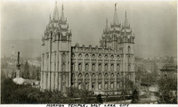
 Caption: "Mormon Temple, Salt Lake City." View of the temple of the Church of Jesus Christ of Latter Day Saints (Truman O. Angell, architect) in Salt Lake City, Utah, dedicated in 1893. Portions of the surrounding areas of Salt Lake City can be seen in the background. See also 96-07-08-alb11-300.
-
 McCarthy Album 05, Photograph 244
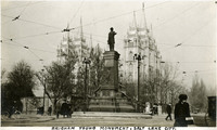
 Caption: "Brigham Young Monument, Salt Lake City.," c. 1916. Designed by Cyrus Edwin Dallin, the Brigham Young Monument (also known as the Pioneer Monument) stands before the Salt Lake Temple in this photograph. The statue was first displayed at the Chicago World's Fair in 1893, and moved to its post at Main and South Temple Streets in Salt Lake City in 1897.
-
 McCarthy Album 05, Photograph 243
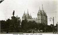
 Caption: "Mormon Temple, Salt Lake City -- Utah.," c. 1916. View of the temple of the Church of Jesus Christ of Latter Day Saints (Truman O. Angell, architect) in Salt Lake City, Utah, dedicated in 1893. The Brigham Young Monument (also known as the Pioneer Monument) stands at the left. Designed by Cyrus Edwin Dallin, this statue commemorating one of the founders of the Church of Jesus Christ and the Latter Day Saints was first displayed at the Chicago World's Fair in 1893, and moved to its post at Main and South Temple Streets in Salt Lake City in 1897.
-
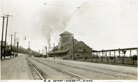 McCarthy Album 05, Photograph 242
 Caption: "R.R. Depot -- Everett, Wash.," c. 1910. View of the Great Northern Railway Station in Everett, Washington, also known as the Bond Street Station, built by the Great Northern Railway in 1910.
-
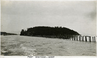 McCarthy Album 05, Photograph 241
 Caption: "Fort Whitman, Wash," c. 1910. View of Goat Island in Puget Sound, Washington. Goat Island was the location of Fort Whitman, a small coastal defense fortification built in 1909. The fort consisted of a single battery and a mine field patrol and observation outpost. The buildings were torn down in 1945 at the conclusion of World War II.
-
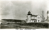 McCarthy Album 05, Photograph 240
 Caption: "Fort Casey Lighthouse, Wash.," c. 1909. View of the lighthouse with fort buildings in the background. Located on Whidbey Island in Puget Sound, the Admiralty Head Lighthouse was built overlooking Admiralty Inlet in 1903. It replaced an earlier structure that had to be moved in 1890 to accommodate the construction of Fort Casey. The second lighthouse, shown here, was built with thick walls in order to withstand earthquakes and the concussion of guns at Fort Casey. Deactivated in 1922, the lighthouse has since been restored by Washington State Parks, and is part of the Fort Casey State Park.
-
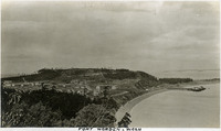 McCarthy Album 05, Photograph 239
 Caption: "Fort Worden, Wash.," c. 1909. Panoramic view of Fort Worden in Port Townsend, Washington, on Admiralty Inlet of Puget Sound. Construction began on the fort in 1898. By 1902 it was serving as an active U.S. Army base. Fort Worden was part of the "triangle of fire," three coastal defense fortifications (Fort Casey, Fort Worden, and Fort Flagler) guarding the entrance to Puget Sound. The U.S. sold the property to the state of Washington in 1957. In 1973, the fort and surrounding area opened as Fort Worden State Park.
-
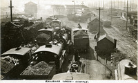 McCarthy Album 05, Photograph 238
 Caption: "Railroad Yards -- Seattle.," c. 1905-1909. View of busy rail yard in Seattle, with a series of trains loaded with what appears to be gravel or rubble, as well as sheds, a water tower, and several other outbuildings.
-
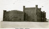 McCarthy Album 05, Photograph 237
 Caption: "State Armory -- Seattle.," c. 1910. View of castle-like armory building for the Washington National Guard, built in 1909 near Seattle's Pike Place Market. It was demolished in 1968.
-
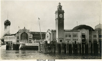 McCarthy Album 05, Photograph 236
 Caption: "Seattle Docks," c. 1914. Dock facilities at Seattle, showing a clock tower, as well as the G.T.P., or Grand Trunk Pacific, dock, a shipping pier at the end of Madison Street (the G.T.P. watchtower is visible at the far left of the photograph). This dock, built in 1910, was destroyed by a fire on July 30, 1914. It was rebuilt, but without the watchtower, and served the city until 1964 when it was demolished.
-
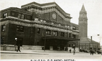 McCarthy Album 05, Photograph 235
 Caption: "O.W.R. & N. R.R. Depot -- Seattle.," c. 1915. Station building for the Oregon-Washington Railroad and Navigation Company, formed in 1910 from the Oregon Railroad and Navigation Company as a subsidiary of the Union Pacific Railroad. Designed by architect Daniel J. Patterson, the Beaux Arts-style station opened in 1911.
-
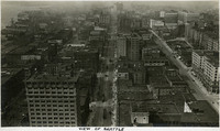 McCarthy Album 05, Photograph 234
 Caption: "View of Seattle," c. 1915. Bird's eye view of Seattle's downtown area, possibly from the Smith Tower. Second Avenue runs down the center of the photograph.
-
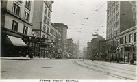 McCarthy Album 05, Photograph 233
 Caption: "Second Ave. -- Seattle.," c. 1915. Street scene showing Seattle's Second Avenue. Electric streetcars and the Smith Tower can be seen in the distance. See also 96-07-08-alb08-091.
-
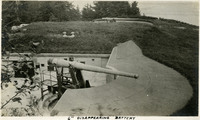 McCarthy Album 05, Photograph 232
 Caption: "6" Disappearing Battery," c. 1905-1909. A 6" disappearing gun in a barbette (gun emplacement). Retracting or disappearing guns were a form of artillery developed in the nineteenth century in which heavy artillery guns were placed on rotating carriages that allowed retraction of the weapon after firing, to enable reloading while under enemy fire.
-
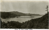 McCarthy Album 05, Photograph 231
 Caption: "Scene at Fort Canby, Wash.," c. 1909. View of jetty and wharf facilities jutting out from the shoreline near Fort Canby in the state of Washington. See also 96-07-08-alb05-171.
-
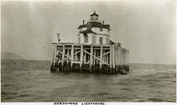
 McCarthy Album 05, Photograph 230
 Caption: "Canby Lighthouse.," c. 1905-1909. The Cape Disappointment Lighthouse sits on a rocky point overlooking the mouth of the Columbia River. Built in the 1850s, the lighthouse was electrified in 1934 and automated in 1973. The lighthouse is now part of the Cape Disappointment State Park (formerly Fort Canby State Park).
-
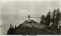
 McCarthy Album 05, Photograph 229
 Caption: "Desdamona [sic] Lighthouse.," c. 1905-1909. View of the Desdemona Lighthouse, constructed in 1901 or 1902 on wood pilings over a group of shoals at the mouth of the Columbia River. The shoals carry the same name as the lighthouse, both of which are named for the boat Desdemona which ran aground and was destroyed by the shoals in 1857. The lighthouse was automated in 1934, and its light eventually removed in 1965.
-
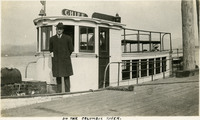 McCarthy Album 05, Photograph 228
 Caption: "On the Columbia River," c. 1905-1909. Unidentified man standing on the deck of a small ferry or other type of boat on the Columbia River.
-
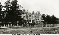 McCarthy Album 05, Photograph 227
 Caption: "Flavel Hotel -- on the Columbia River.," c. 1905-1909. Built at the turn of the century, the Flavel Hotel housed passengers waiting to board steamships of the Great Northern Pacific Steamship Company bound for San Francisco and other ports. The Flavel family constructed the hotel as part of an effort to establish the town of Flavel on Tansy Point along the Columbia River. The town failed to attract sufficient residents, however, and was annexed into Warrenton by 1918.
-
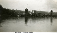 McCarthy Album 05, Photograph 226
 Caption: "Saw Mill -- Astoria Oregon," c. 1905-1909. Saw mill on the Columbia River, near Astoria.
-
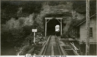 McCarthy Album 05, Photograph 225
 Caption: "S.P. & S. Tunnel on the Columbia River.," c. 1908-1910. Shows a tunnel through a hillside along the Spokane, Portland, and Seattle Railway line near the Columbia River and John Day River.