-
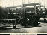 McCarthy Album 08, Photograph 026
 Caption: "U. S. 10" New Model Gun Carriage.," c. 1908-1912. Side view of a coastal defense disappearing gun carriage, without the gun barrel installed. Retracting or disappearing guns were a form of artillery developed in the nineteenth century in which heavy artillery guns were placed on rotating carriages that allowed retraction of the weapon after firing, to enable reloading while under enemy fire.
-
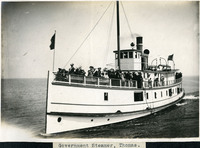 McCarthy Album 08, Photograph 025
 Caption: "Government Steamer, Thomas.," c. 1980-1912. Shows a small steamship or ferry, its deck occupied by a group of unidentified people.
-
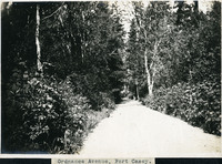 McCarthy Album 08, Photograph 024
 Caption: "Ordnance Avenue, Fort Casey." C. 1908-1912. Rural road lined with thick vegetation and trees.
-
 McCarthy Album 08, Photograph 023
 Caption: "Clife [sic] House S.F.," c. 1908-1912. View of San Francisco's Cliff House overlooking Ocean Beach. The building shown here is the fourth iteration of the Cliff House, a neo-classical design built after a fire destroyed the Victorian structure previously at the site in 1907. Reconstruction of the iconic restaurant began in 1908, and a new Cliff House opened in 1909 (the building in this photograph). This neo-classical building was extensively remodeled in the 1930s.
-
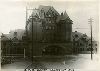 McCarthy Album 08, Photograph 022
 Caption: "C.P.R. Depot Vancouver B.C.," c. 1908-1912. View of the imposing, gothic chateau-like Vancouver Station, serving the Canadian Pacific Railway. Built in 1899, this station only stood until 1914, when it was replaced with a newer facility and subsequently demolished.
-
 McCarthy Album 08, Photograph 021
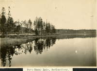
 Caption: "Fort Casey Lake, Reflections.," c. 1908-1912. Peaceful scene at Crocket Lake near Fort Casey, the water so still that the trees and surrounding hills are clearly reflected in the lake's waters.
-
 McCarthy Album 08, Photograph 020
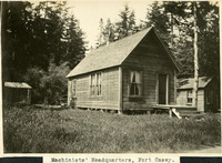
 Caption: "Machinists' Headquarters, Fort Casey.," c. 1908-1912. View of building with gabled roof and sides sheathed in wood planks, with a small shed to the left and another small building to the right. Fort Casey was part of the "triangle of fire," three coastal defense fortifications (Fort Casey, Fort Worden, and Fort Flagler) guarding the entrance to Puget Sound. Construction began on the fort in 1897, and the U.S. Army used the facility until the 1950s, when the fort was decommissioned. The area is now a state park.
-
 McCarthy Album 08, Photograph 019
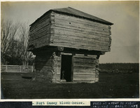
 Caption: "Fort Casey block-house." and "USED AS A FORT TO FIGHT INDIANS IN EARLY DAYS," c. 1908-1912. View of a blockhouse, a timber structure built by European settlers to guard against attack during the Indian Wars of 1855-1857. See also 96-07-08-alb08-067.
-
 McCarthy Album 08, Photograph 018
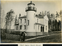
 Caption: "Fort Casey Light House [sic]," c. 1905. Located on Whidbey Island in Puget Sound, the Admiralty Head Lighthouse was built overlooking Admiralty Inlet in 1903. It replaced an earlier structure that had to be moved in 1890 to accommodate the construction of Fort Casey. The second lighthouse, shown here, was built with thick walls in order to withstand earthquakes and the concussion of guns at Fort Casey. The man shown in the photograph is likely Charles H. Davis, who was appointed keeper of the lighthouse in 1900 and served until his death in 1914. The lighthouse, deactivated in 1922, has since been restored by Washington State Parks, and is part of the Fort Casey State Park. See also 96-07-08-alb03-065.
-
 McCarthy Album 08, Photograph 017
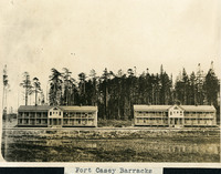
 Caption: "Fort Casey Barracks," c. 1908-1912. View of two barracks buildings at Fort Casey, located on Whidbey Island in Puget Sound. Construction began on the fort in 1897. Fort Casey was part of the "triangle of fire," three coastal defense fortifications (Fort Casey, Fort Worden, and Fort Flagler) guarding the entrance to Puget Sound. The U.S. Army used the facility until the 1950s, when the fort was decommissioned. The area is now a state park.
-
 McCarthy Album 08, Photograph 016
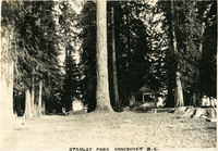
 Caption: "Stanley Park Vancouver B.C.," c. 1908-1912. View of what may be a campsite, surrounded by tall trees and featuring a small gazebo and bench. The City of Vancouver opened Stanley Park in 1888. The 405-hectare park is even now thickly forested, and remains Vancouver's largest park. It is located on the northern edge of the city, surrounded on three sides by Vancouver Harbor and English Bay.
-
 McCarthy Album 08, Photograph 015
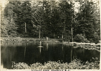
 Caption: "Stanley Park Vancouver B.C.," c. 1908-1912. Shows a pond with central fountain, surrounded by lush vegetation including evergreen trees. A group of people stands at the pond's edge in the distance. The City of Vancouver opened Stanley Park in 1888. The 405-hectare park is even now thickly forested, and remains Vancouver's largest park. It is located on the northern edge of the city, surrounded on three sides by Vancouver Harbor and English Bay.
-
 McCarthy Album 08, Photograph 014
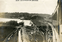
 Caption: "New Westminster Bridge.," c. 1908-1912. View of the New Westminster Bridge (also known as the New Westminster Rail Bridge or the Fraser River Swing Bridge), which opened to traffic in 1904. The lower deck carried trains, while the upper deck (which was removed in 1937) was accessible to both foot and vehicle traffic.
-
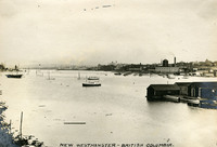 McCarthy Album 08, Photograph 013
 Caption: "New Westminster -- British Columbia.," c. 1908-1912. View of the riverfront of New Westminster, now part of the Greater Vancouver region.
-
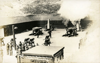 McCarthy Album 08, Photograph 012
 Caption: "Mortar Gun Practice -- Full Service, Fort Worden, Pt Townsend, Wash," c. 1910. The postcard shows several Howitzers, one of which is firing, as well as a group of men standing to the side with their hands over their ears. Construction began on Fort Worden in 1898, and by 1902 it was serving as an active U.S. Army base. Fort Worden was part of the "triangle of fire," three coastal defense fortifications (Fort Casey, Fort Worden, and Fort Flagler) guarding the entrance to Puget Sound. The U.S. sold the property to the state of Washington in 1957. In 1973, the fort and surrounding area opened as Fort Worden State Park.
-
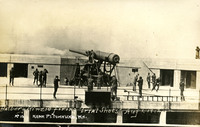 McCarthy Album 08, Photograph 011
 Caption: "Battery Kinzie firing 'Trial Shots' Aug 1, 1912" and "No 10 Near Pt. Townsend, WA." Battery Kinzie was a coastal defense battery designed to include two 12-inch disappearing guns, installed at Fort Worden. Construction began in 1908. It was turned over to the U.S. Army's Coast Artillery Corps in 1912 for use in defending the entrance to Puget Sound. This postcard shows one of the 12-inch guns firing, with several unidentified men standing nearby holding their hands to their ears.
-
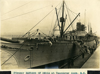 McCarthy Album 08, Photograph 010
 Caption: "Steamer EMPRESS OF INDIA at Vancouver dock, B.C.," c. 1908-1912. View of the Empress of India, built by England's Naval Construction & Armaments Co. in 1890 for the Canadian Pacific Steamships company. The Empress of India could accommodate up to 700 passengers, and was also used to carry mail between Hong Kong and Great Britain. She was sold in 1914 and refitted as a hospital ship for Indian soldiers. She was sold a final time in 1923, for scrap in Bombay.
-
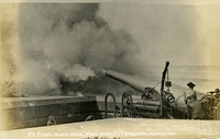 McCarthy Album 08, Photograph 009
 Caption: "No. 9 Firing 12 inch Rifle, Fort near Pt. Townsend, Washington." Photographer and date unknown, likely c. 1910. This postcard shows a 12-inch coastal defense gun firing from a barbette.
-
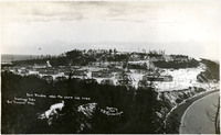 McCarthy Album 08, Photograph 008
 Caption: "Fort Worden when the snow has come. Greetings from Port Townsend - Wash." and "Photo by P.M. Richardson, 1910." This postcard shows an overview of Fort Worden in Port Townsend, Washington, on Admiralty Inlet of Puget Sound. Construction began on the fort in 1898, and by 1902 it was serving as an active U.S. Army base. Fort Worden was part of the "triangle of fire," three coastal defense fortifications (Fort Casey, Fort Worden, and Fort Flagler) guarding the entrance to Puget Sound. The U.S. sold the property to the state of Washington in 1957. In 1973, the fort and surrounding area opened as Fort Worden State Park.
-
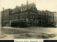 McCarthy Album 08, Photograph 007
 Caption: "Vancouver Hotel, Vancouver, B.C.," c. 1908-1912. View of the Hotel Vancouver, designed by architect T.C. Sorly for the Canadian Pacific Railway (CPR). This photograph shows the first building on the site, which opened in 1888. By 1916, the area had grown so much that the CPR razed this building and constructed a new, larger, more modern facility.
-
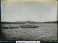 McCarthy Album 08, Photograph 006
 Caption: "ESQUIMALT, Victoria, B. C.," c. 1908-1912. View of the Esquimalt area on the southern tip of Vancouver Island in British Columbia. The photograph shows an ocean scene, possibly the Esquimalt Lagoon, with a ship in the middle distance and mountains in the far distance.
-
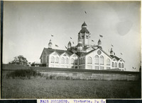 McCarthy Album 08, Photograph 005
 Caption: "FAIR BUILDING, Victoria, B. C.," c. 1901-1907. View of an exhibition building with multiple turrets and flags, constructed in Oak Bay (near Victoria) circa 1891. Designed by Cornelius Soule, the building was destroyed by fire in 1907.
-
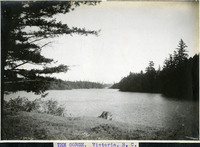 McCarthy Album 08, Photograph 004
 Caption: "THE GORGE, Victoria, B. C.," c. 1906. View of the Gorge, a narrow tidal inlet in Victoria running from Selkirk Trestle to the Craigflower Bridge. The Gorge became a popular recreation destination for the area's residents as Victoria grew.
-
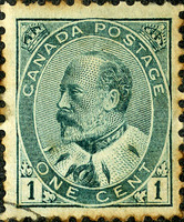 McCarthy Album 08, Photograph 003c
 No Caption: c. 1905. Canadian one-cent postage stamp bearing the image of Edward VII, King of the United Kingdom from 1901-1910.
-
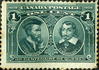 McCarthy Album 08, Photograph 003b
 No Caption: Canadian one-cent postage stamp commemorating the three-hundred year anniversary of the founding of Quebec in 1608. This stamp features portraits of Jacques Cartier and Samuel de Champlain, early explorers of Canada. Cartier was the first to claim Canada for the French crown in 1534, while Champlain founded New Canada and Quebec City in 1608.
-
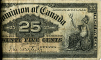 McCarthy Album 08, Photograph 003a
 No Caption: c. 1900. Canadian 25-cent bill inserted into binding of photograph album.
-
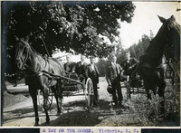 McCarthy Album 08, Photograph 003
 Caption: "A DAY ON THE GORGE, Victoria, B. C.," c. 1906. William McCarthy (center, with moustache) posing with four unidentified men and two horse-and-buggies. The Gorge is a narrow tidal inlet in Victoria running from Selkirk Trestle to the Craigflower Bridge. The inlet became a popular recreation destination for the area's residents as Victoria grew.
-
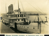 McCarthy Album 08, Photograph 002
 Caption: "Steamer PRINCESS VICTORIA at Vancouver [sic] dock, B.C.," c. 1908-1912. The Princess Victoria was constructed in 1902 by England's C.S. Swan and Hunter Company shipyards. The luxury passenger ship was operated by the Canadian Pacific Railway Company on routes between Victoria and Vancouver, British Columbia and Seattle in Washington until she was sold in 1951 to an oil carrier. Shortly thereafter, in 1953, she struck a rock and sank.
-
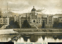 McCarthy Album 08, Photograph 001
 Caption: "Government building, Victoria, B.C.," c. 1908-1912. View of the British Columbia Parliament Buildings in Victoria. Designed by Francis Rattenbury, the construction began on the complex in 1893 and finished four years later. The buildings were first used in 1898.
-
 McCarthy Album 08, Photograph 001a
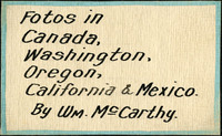
 The frontispiece of this photograph album reads "Fotos [sic] in Canada, Washington, Oregon, California & Mexico. By Wm. McCarthy."
-
 McCarthy Album 03, Photograph 120
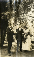
 No Caption: See also 96-07-08-alb07-284 with caption: "The Fatal Wedding." Shows an unidentified bride and groom at an outdoor wedding, at unidentified location, c. 1915.
-
 McCarthy Album 03, Photograph 119
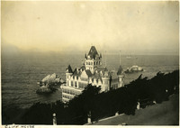
 Caption: "Cliff House." c. 1906. A view of San Francisco's Cliff House from Sutro Heights Park. The Victorian structure shown here is the third building on the site, constructed in 1896. It was later destroyed by a fire, in 1907.
-
 McCarthy Album 03, Photograph 118
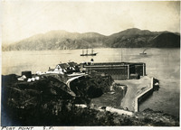
 Caption: "Fort Point S.F." c. 1906. See also 96-07-08-alb06-009 with caption: "Fort Point and Golden Gate." A view of Fort Point in the foreground, with ships in the bay. Fort Point was part of an effort by the U.S. government to protect the Golden Gate, entrance to the San Francisco Bay. Built between 1853-1861 of brick and mortar, the fort included emplacements for 141 guns but never fired a weapon in defense of the Bay.
-
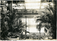 McCarthy Album 03, Photograph 117
 Caption: "Sutro Baths S.F.," c. 1910. Interior shot of the Sutro Baths, north of the Cliff House. Designed by Adolph Sutro in 1894, the bathhouses at one time covered three oceanfront acres just north of Ocean Beach and the Cliff House. Eventually, the Sutro Baths fell into disrepair and what was left of them burned down in 1966. Since 1973, the concrete ruins have been part of the Golden Gate National Recreation Area. See also 96-07-08-alb02-023.
-
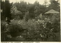 McCarthy Album 03, Photograph 116
 Caption: "Japanese Tea Garden Golden Gate Park," San Francisco, c. 1907. Originally created as a "Japanese Village" exhibit for the 1894 California Midwinter International Exposition, the still existing Japanese Tea Garden is now the oldest public Japanese garden in the United States.
-
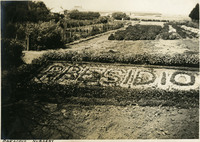 McCarthy Album 03, Photograph 115
 Caption: "Presidio Nursery," shows gardens and "Presidio" spelled out in flowers, San Francisco, c. 1907.
-
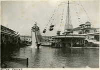 McCarthy Album 03, Photograph 114
 Caption: "The Chutes," c, 1907, were an attraction at an amusement park located on 10th and Fulton Streets in San Francisco from 1902 - 1907.
-
 McCarthy Album 03, Photograph 113
 Caption: "S.F. Before the Fire," shows the central city of San Francisco before the 1906 earthquake and fires, 1906.
-
 McCarthy Album 03, Photograph 112
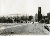
 Caption: "California St. S.F." Shows the devastation from the 1906 earthquake and fires, along California Street in San Francisco, 1906.
-
 McCarthy Album 03, Photograph 111
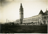
 Caption: "Ferry Building," c. 1906. A view of the San Francisco Ferry Building (A. Page Brown, architect) during repairs from the 1906 earthquake. The Beaux Arts structure is located on San Francisco's Embarcadero and features a 245 foot tall clock tower, with four clock dials, each 22 feet in diameter.
-
 McCarthy Album 03, Photograph 110
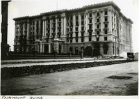
 Caption: "Fairmount Ruins." Shows the damage from the 1906 earthquake fire to the Fairmont Hotel on Nob Hill in San Francisco, 1906. Although construction was mostly finished in 1906, the advent of the San Francisco earthquake and fire of that year damaged the hotel's interior and delayed opening until 1907. It was the first hotel in what is now the Fairmont Hotels and Resorts chain. In 1945, the San Francisco hotel was host to an international conference that culminated in the formation of the United Nations.
-
 McCarthy Album 03, Photograph 109
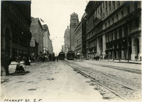
 Caption: "Market St. S.F." See also 96-07-08-alb06-197 with caption: "Building up on Market Street, c. 1907. A view of repairs being made to Market Street, after the damage of the 1906 earthquake.
-
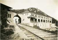 McCarthy Album 03, Photograph 108
 Caption: "Mt. Tamalpais." Shows the Muir Woods Railway leading to the Tavern of Tamalpais, Marin County, c. 1907.
-
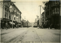 McCarthy Album 03, Photograph 107
 Caption: "Fillmore St." Shows a busy Fillmore Street in San Francisco, c. 1907.
-
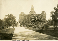 McCarthy Album 03, Photograph 106
 Caption: "City Hall San Jose," c. 1905 (Theodore Lenzen, Architect), served as the San Jose City Hall from 1889 until it was demolished and replaced in 1958.
-
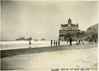 McCarthy Album 03, Photograph 105
 Caption: "Limb Show at the Cliff." Shows two women holding up their skirts as they walk into the surf at Ocean Beach, with the Victorian-style Cliff House in the background, San Francisco, c. 1906.
-
 McCarthy Album 03, Photograph 104
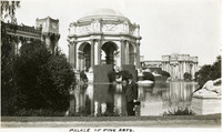
 Caption: "Palace of Fine Arts, San Francisco," built for the Panama-Pacific International Exposition. William McCarthy is seen smiling for the camera, 1915.
-
 McCarthy Album 03, Photograph 103
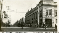
 Caption: "K Street Sacramento. Weinstock Lubins Store," Sacramento, California, c. 1910.
-
 McCarthy Album 03, Photograph 102
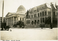
 Caption: "San Jose Court House," San Jose, c. 1905. The Old Courthouse was completed in 1868, the Hall of Records next door was built in 1893.
-
 McCarthy Album 03, Photograph 101
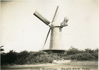
 Caption: "Dutch Windmill Golden Gate Park," in San Francisco, c. 1906.