-
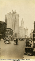 McCarthy Album 09, Photograph 089
 Caption: "London Guarantee & Wrigley Bldg. Chicago," c. 1923. This photograph, taken at street level, features the London Guarantee Building (with the small cupola still under construction at its top) and the Wrigley Building (just to the right of the London Guarantee Building). The London Guarantee Building (also called the London Guaranty and Accident Building), designed by Alfred S. Alschuler, was completed in 1923. The Wrigley Building, constructed by the famous chewing gum magnate William Wrigley, Jr., consists of two towers. The south tower was completed in 1921, while the north tower was finished in 1924 (you can make out construction scaffolding on the top of the tower in this photograph).
-
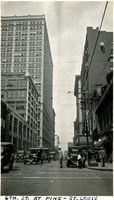 McCarthy Album 09, Photograph 088
 Caption: "6th. St. At Pine - St. Louis," c. 1923. A bustling street scene on 6th Street in St. Louis, at its intersection with Pine.
-
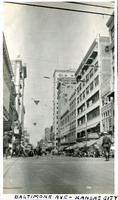 McCarthy Album 09, Photograph 087
 Caption: "Baltimore Ave - Kansas City," c. 1923. A busy street scene on Baltimore Ave in Kansas City.
-
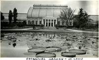 McCarthy Album 09, Photograph 086
 Caption: "Botanical Garden - St. Louis," c. 1923. View of the Palm House, built in 1915 to house tropical plants in the Missouri Botanical Gardens in St. Louis. It was torn down in 1959 to make room for the domed geodesic Climatron building which still stands at the site. See also 96-07-08-alb04-091.
-
 McCarthy Album 09, Photograph 085
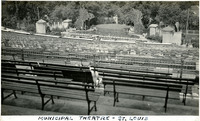
 Caption: "Municipal Theatre - St. Louis," c. 1923. Built in 1917, the St. Louis Municipal Opera Theatre was the first municipally-owned outdoor theatre in the United States. The amphitheater seats 11,000 people, and is still in use today.
-
 McCarthy Album 09, Photograph 084
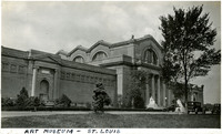
 Caption: Art Museum - St. Louis," c. 1923. The Saint Louis Art Museum features elements of the Greek Revival style. It began life as the Palace of Fine Arts for the World's Fair held in St. Louis in 1904. The museum moved into the building after the fair's completion.
-
 McCarthy Album 09, Photograph 083
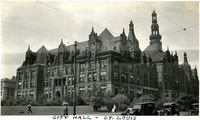
 Caption: "City Hall - St. Louis," c. 1923. Grace McCarthy poses in front of the St. Louis City Hall, while a man mows the lawn and an adult and child stroll on the sidewalk. The French Renaissance Revival style building, designed by George Richard Mann, has been home to the city's governmental offices since 1898.
-
 McCarthy Album 09, Photograph 082
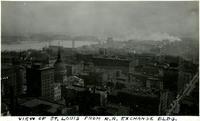
 Caption: "View of St. Louis from R.R. Exchange Bldg," c. 1923. Merchant's Bridge and the Old Courthouse (domed building just to left of center) can be seen in this bird's eye view of St. Louis.
-
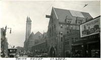 McCarthy Album 09, Photograph 081
 Caption: "Union Depot St. Louis," c. 1923. Opened in 1894, the St. Louis Union Depot was designated a National Historic Landmark in 1970. Designed by Theodore Link, the building features a 280-foot-tall clock tower. At the time of its construction, it was the largest, busiest railroad station in the world.
-
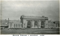 McCarthy Album 09, Photograph 080
 Caption: "Union Depot - Kansas City," c. 1923. This Beaux Arts-style rail station opened in 1914, replacing a small depot from 1871. Decreasing rail passenger traffic after World War II resulted in the closure of the depot in 1985. However, the restored depot later reopened in 1999, containing museums and other attractions. In 2002, it was again put to service as a rail depot when Amtrak again brought passenger trains to the area.
-
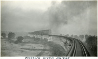 McCarthy Album 09, Photograph 079
 Caption: "Missouri River Bridge," c. 1923. The Union Pacific Missouri River Bridge connects Council Bluffs, Iowa, with Omaha, Nebraska. The rail truss bridge was the third in the location, opening in 1916.
-
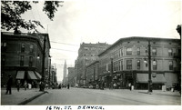 McCarthy Album 09, Photograph 078
 Caption: "16th. St. Denver," c. 1923. A bustling scene of cars and people on Denver's 16th street.
-
 McCarthy Album 09, Photograph 077
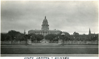
 Caption: "State Capitol - Denver," c. 1923. The Colorado State Capitol in Denver is a Neoclassical building built from Colorado rose onyx, a stone so rare that all known reserves were used in the capitol's construction. Designed by Elijah E. Myers, it was first occupied in 1894.
-
 McCarthy Album 09, Photograph 076
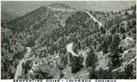
 Caption: "Serpentine Drive - Colorado Springs," c. 1923. A bird's eye view of Serpentine Drive, a twisty mountain road near Manitou Springs and Colorado Springs.
-
 McCarthy Album 09, Photograph 075
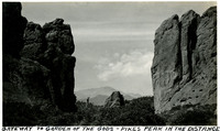
 Caption: "Gateway to Garden of the Gods - Pikes Peak in the Distance," c. 1923. Two massive rock formations rise on either side of this photograph, bracketing Pikes Peak in the distance. The Garden of the Gods, a region of spectacular red rock formations in Colorado, was designated a National Natural Landmark in 1971.
-
 McCarthy Album 09, Photograph 074
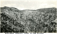
 Caption: "Williams Canion [sic] - Cave of the Winds," c. 1923. View of a rugged canyon with a small building perched on one wall featuring a sign reading "CAVE." In 1880, two brothers, George and John Pickett, discovered the entrance to a large cave system in Williams Canyon. Further exploration resulted in opening more caverns within the system. The site became a tourist attraction called "Cave of the Winds," with guided tours having been on offer since 1881.
-
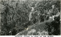 McCarthy Album 09, Photograph 073
 Caption: "Temple Drive to Cave of the Winds," c. 1923. Bird's eye view of a road at the bottom of a canyon, on a drive to Cave of the Winds. Two brothers discovered the entrance to the large cave system in 1880, in Williams Canyon just outside of Manitou Springs. Further exploration resulted in opening more caverns within the system, and the site became a tourist attraction, with guided tours having been on offer since 1881.
-
 McCarthy Album 09, Photograph 072
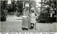
 Caption: "Chief Manitou - Manitou Soda Springs," c. 1923. William McCarthy, wearing a Native American headdress and attire, stands next to Pedro Cajete. Mr. Cajete, better known to many as Chief Manitou, was a Native American of the Tewa tribe near Santa Fe, New Mexico, who was hired to promote tourism in the Manitou Springs/Colorado Springs area of Colorado. He often sold trinkets and posed for photographs with tourists near the mouth of Manitou Cave, resulting in his moniker Chief Manitou.
-
 McCarthy Album 09, Photograph 071
 Caption: "Chief Manitou of Taos N. M. - Manitou Soda Springs," c. 1923. Grace McCarthy, wearing a Native American headdress and beaded blanket, stands next to a smiling Pedro Cajete in traditional dress. Mr. Cajete, better known to many as Chief Manitou, was a Native American of the Tewa tribe near Santa Fe, New Mexico, who was hired to promote tourism in the Manitou Springs/Colorado Springs area of Colorado. He often sold trinkets and posed for photographs with tourists near the mouth of Manitou Cave, resulting in his moniker Chief Manitou.
-
 McCarthy Album 09, Photograph 070
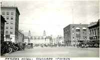
 Caption: "Antlers Hotel - Colorado Springs," c. 1923. A busy street scene in Colorado Springs, with the Antlers Hotel rising in the background. Built in 1901 to replace a previous building lost in a fire, this Italian Renaissance structure was torn down in 1967 and replaced with a fourteen-floor hotel, which still stands today.
-
 McCarthy Album 09, Photograph 069
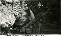
 Caption: "Seven Falls - Colorado Springs," c. 1923. View from the top of a narrow wooden staircase, looking back down onto a resort building and a small creek. The stairs lead to a series of seven cascading waterfalls of South Cheyenne Creek. The area has been a privately-owned tourist attraction since the 1880s.
-
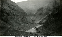 McCarthy Album 09, Photograph 068
 Caption: "Eagle River D. & R. G. R. R," c. 1923. Denver and Rio Grande Western Railroad tracks run next to the Eagle River at the bottom of a canyon in this photograph. A wall of timber shores up part of one side of the canyon wall in the distance. The Denver and Rio Grande (D&RG) primarily operated railroad lines between Denver, Colorado and Salt Lake City, Utah, with other lines stretching into New Mexico.
-
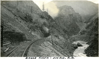 McCarthy Album 09, Photograph 067
 Caption: "Eagle River - D. & R. G. R. R," c. 1923. Denver and Rio Grande Western Railroad tracks run next to the Eagle River at the bottom of a canyon in this photograph, toward a tunnel with steam or smoke coming out of the entry. The Denver and Rio Grande (D&RG) primarily operated railroad lines between Denver, Colorado and Salt Lake City, Utah, with other lines stretching into New Mexico.
-
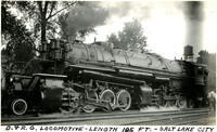 McCarthy Album 09, Photograph 066
 Caption: "D. & R. G. Locomotive - Length 105 FT. - Salt Lake City," c. 1923. View of Locomotive #3501 of the Denver and Rio Grande Western Railroad. The Denver and Rio Grande (D&RG) primarily operated railroad lines between Denver, Colorado and Salt Lake City, Utah, with other lines stretching into New Mexico.
-
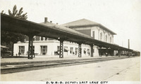 McCarthy Album 09, Photograph 065
 Caption: "D. & R. G. Depot, Salt Lake City," c. 1923. Constructed in 1910 by the Denver and Rio Grande Western Railroad (D&RGW), this depot operated under the auspices of that railroad company until the 1970s. It served as a passenger depot for Amtrak from 1986 to 1999. The building is currently home to the Division of Utah State History and the Utah Department of Heritage & Arts.
-
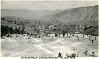 McCarthy Album 09, Photograph 064
 Caption: "Government Headquarters," c. 1923. Bird's eye view of the Mammoth Hot Springs Hotel (the large, flat-roofed building in the center of the photograph) and surrounding complex of buildings in Yellowstone National Park.
-
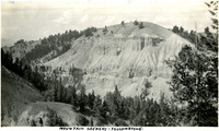 McCarthy Album 09, Photograph 063
 Caption: "Mountain Scenery - Yellowstone," c. 1923. A domed mountain dominates this photograph, with sheer rocky cliffs and other geologic formations on its flanks.
-
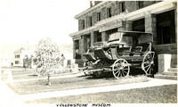 McCarthy Album 09, Photograph 062
 Caption: "Yellowstone Museum," c. 1923. Two horse-drawn stages, at least one of which was operated by the Yellowstone-Western Stage Company, parked in front of the Yellowstone Information Office, which also housed a museum.
-
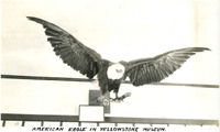 McCarthy Album 09, Photograph 061
 Caption: "American Eagle in Yellowstone Museum," c. 1923. A taxidermized bald eagle perched on a branch, one of the exhibits at a museum housed within the Yellowstone Information Office.
-
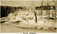 McCarthy Album 09, Photograph 060
 Caption: "Angel Terrace," c. 1923. Dead trees around Angel Terrace, along the upper terrace loop of Mammoth Hot Springs.
-
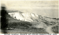
 McCarthy Album 09, Photograph 059
 Caption: "Jupiter Terrace - Mammoth Hot Springs," 1923. Jupiter Terrace is part of the Lower Terraces of Mammoth Hot Springs.
-
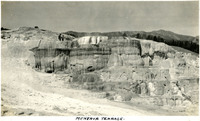 McCarthy Album 09, Photograph 058
 Caption: "Menerva [sic] Terrace," c. 1923. A prominent feature of the Mammoth Hot springs, the Minerva Terrace is a series of travertine terraces, formed from limestone. In this photograph, two unidentified men stand at the upper left, viewing the terrace.
-
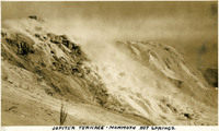
 McCarthy Album 09, Photograph 057
 Caption: "Jupiter Terrace - Mammoth Hot Springs - Yellowstone Park," c. 1923. Jupiter Terrace is part of the Lower Terraces of Mammoth Hot Springs. A group of riding horses is seen at lower left, and a road flanks what appear to be observation points at the bottom right.
-
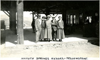 McCarthy Album 09, Photograph 056
 Caption: "Mammoth Springs Resort. - Yellowstone," c. 1923. William and Grace McCarthy pose in front of the Mammoth Springs Resort with three unidentified people. Originally called the National Hotel, the building opened for business in 1883. It underwent significant alterations and renovations between 1911 and 1913, by which time the resort was known as the Mammoth Hot Springs Hotel. The hotel was torn down in 1936 in favor of a more modern facility.
-
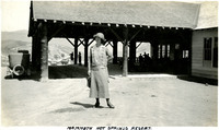 McCarthy Album 09, Photograph 055
 Caption: "Mammoth Hot Springs Resort," c. 1923. Grace McCarthy poses in front of Mammoth Hot Springs Resort. Originally called the National Hotel, the building opened for business in 1883. It underwent significant alterations and renovations between 1911 and 1913, by which time the resort was known as the Mammoth Hot Springs Hotel. The hotel was torn down in 1936 in favor of a more modern facility.
-
 McCarthy Album 09, Photograph 054
 Caption: "Devil's Kitchen," c. 1923. This photograph shows several people descending into and standing around the entry to Devil's Kitchen, an extinct hot spring that left behind a cavern. Once a popular tourist attraction for its small opening that made visitors feel as if they were descending into the underworld, the site was closed in 1939 because the cavern periodically fills with dangerous levels of carbon dioxide.
-
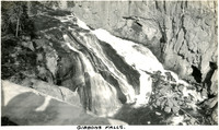 McCarthy Album 09, Photograph 053
 Caption: "Gibbons Falls," c. 1923. Yellowstone National Park's Gibbon Falls is located on the Gibbon River. The falls drop roughly eighty-four feet in a gradual descent.
-
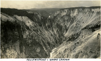
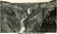
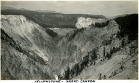 McCarthy Album 09, Photograph 052
 Caption: "Yellowstone - Grand Canyon," c. 1923. Bird's eye view of the Grand Canyon of the Yellowstone. The Yellowstone River can be glimpsed at the bottom of the Canyon near the center of the photograph. The Canyon is approximately 24 miles long, and between 800 and 1,200 feet deep.
-
 McCarthy Album 09, Photograph 051
 Caption: "Yellowstone - Grand Canyon," c. 1923. Bird's eye view of a portion of the Grand Canyon of the Yellowstone. The 308-foot tall cascade of Lower Yellowstone Falls can be seen at the top of the photograph, flowing into the Canyon. The Canyon is approximately 24 miles long, and between 800 and 1,200 feet deep.
-
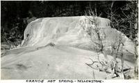 McCarthy Album 09, Photograph 050
 Caption: "Orange Hot Spring - Yellowstone, " c. 1923. View of Yellowstone's Orange Spring Mound, part of the complex of thermal features at the Mammoth Hot Springs.
-
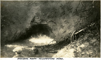 McCarthy Album 09, Photograph 049
 Caption: "Dragons Mouth - Yellowstone Park," c. 1923. This hot spring originates deep underground. Rising gas and steam create pressure bubbles within the mud of the cavern. When they burst against the cave roof, they emit a growling, booming sound. Steam also drifts from the cavern entrance, creating the illusion of smoke from a dragon's mouth.
-
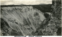 McCarthy Album 09, Photograph 048
 Caption: "Yellowstone Grand Canyon," c. 1923. One wall of the Grand Canyon of the Yellowstone can be seen in this photograph, viewed from the opposite rim of the Canyon. The Canyon is approximately 24 miles long, and between 800 and 1,200 feet deep.
-
 McCarthy Album 09, Photograph 047
 Caption: " Grand Canyon - Yellowstone," c. 1923. Bird's eye view of the Grand Canyon of the Yellowstone. The 308-foot tall cascade of Lower Yellowstone Falls can be seen at the top of the photograph, flowing into the Canyon. The Canyon is approximately 24 miles long, and between 800 and 1,200 feet deep.
-
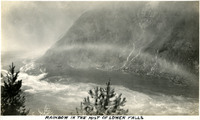 McCarthy Album 09, Photograph 046
 Caption: "Rainbow in the Mist of Lower Falls," c. 1923. A rainbow over Lower Yellowstone Falls appears as an arch of mist in this black-and-white photograph.
-
 McCarthy Album 09, Photograph 045
 No caption. c. 1923. As the Yellowstone River flows north from Yellowstone Lake it passes over two waterfalls (Upper and Lower Yellowstone Falls) before reaching the Yellowstone Grand Canyon. This photograph shows the Upper Yellowstone Falls, 109 feet in height, as seen from a nearby peak. One arch of the Chittenden Bridge can be seen crossing the Yellowstone River upstream of the falls (in the upper center of the photograph). Built in 1903, this Melan arch bridge stood until the 1960s, when it was torn down in favor of a new, more modern structure.
-
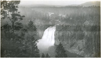
 McCarthy Album 09, Photograph 044
 Caption: "Lower Falls - Yellowstone," c. 1923. This photograph features the massive Lower Yellowstone Falls, as seen from the falls' base. A group of unidentified people standing to one side provides some sense of scale. As the Yellowstone River flows north from Yellowstone Lake it passes over two waterfalls (Upper and Lower Yellowstone Falls) before reaching the Yellowstone Grand Canyon. The 308-foot Lower Yellowstone Falls carries more water volume than any other waterfall in the Rocky Mountains.
-
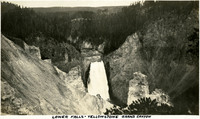 McCarthy Album 09, Photograph 043
 Caption: "Lower Falls - Yellowstone Grand Canyon," c. 1923. As the Yellowstone River flows north from Yellowstone Lake it passes over two waterfalls (Upper and Lower Yellowstone Falls) before reaching the Yellowstone Grand Canyon. This photograph shows the 308-foot Lower Yellowstone Falls, as seen from a nearby mountain top or bluff. It carries more water volume than any other waterfall in the Rocky Mountains.
-
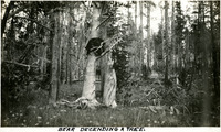 McCarthy Album 09, Photograph 042
 Caption: "Bear Decending [sic] a Tree," c. 1923. The bear in 96-07-08-alb09-041 is seen beginning his descent from the tree in this photograph.
-
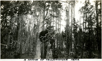 McCarthy Album 09, Photograph 041
 Caption: "A Native of Yellowstone Park," c. 1923. A bear climbing a tree in Yellowstone National Park.
-
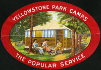 McCarthy Album 09, Photograph 040a
 No caption. This colorful decal advertises "Yellowstone Park Camps, The Popular Service." Three people lounge in camp chairs in front of a small cabin.