-
 McCarthy Album 09, Photograph 288
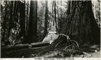
 Caption: "Three Brothers - Mariposa Grove," c. 1917. Two unidentified people pose in the Mariposa Grove next to three Giant Sequoias.
-
 McCarthy Album 09, Photograph 287
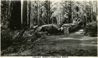
 Caption: "Fallen Giant - Mariposa Grove," c. 1917. Grace McCarthy poses with two unidentified people next to the Fallen Monarch, the enormous trunk of a fallen Giant Sequoia in Maripose Grove. It is estimated that the tree fell more than 300 years ago, but the natural resistance of Giant Sequoias to rot has preserved the trunk to the present time.
-
 McCarthy Album 09, Photograph 286
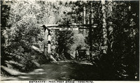
 Caption: "Entrance - Mariposa Grove- Yosemite," c. 1917. Grace McCarthy stands with an automobile near the entrance to Maripose Grove in Yosemite National Park. The Mariposa Grove, near Wawona, is the largest grove of Giant Sequoia trees in Yellowstone National Park. It also includes two of the thirty largest Giant Sequoias in the world.
-
 McCarthy Album 09, Photograph 285
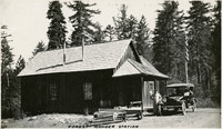
 Caption: "Forest Ranger Station," c. 1917. Grace McCarthy (in the driver's seat of the automobile) and an unidentified man taking a break from driving by pausing next to a small plank house, identified as a forest ranger station by William McCarthy.
-
 McCarthy Album 09, Photograph 284
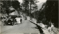
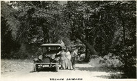
 Caption: "Yosemite Driveways," c. 1917. Grace McCarthy and two unidentified people pose next to a vehicle on a dirt road in Yosemite National Park.
-
 McCarthy Album 09, Photograph 283
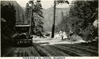
 Caption: "Yosemite - El Portal Highway," c. 1917. Grace McCarthy and an unidentified man and woman sit at the side of the El Portal Road, now California State Route 140. Their automobile is parked across the road, and timbered, granite mountainsides provide the background.
-
 McCarthy Album 09, Photograph 282
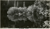
 Caption: "Mirror Lake," c. 1917. Mirror Lake in Yosemite National Park, on Tenaya Creek, is the remains of a glacial lake that used to fill most of the valley. Its calm waters provide near-perfect reflections of the surrounding natural splendor.
-
 McCarthy Album 09, Photograph 281
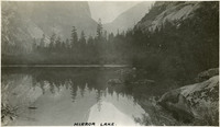
 Caption: "Mirror Lake," c. 1917. Mirror Lake in Yosemite National Park, on Tenaya Creek, is the remains of a glacial lake that used to fill most of the valley. Its calm waters provide near-perfect reflections of the surrounding natural splendor.
-
 McCarthy Album 09, Photograph 280
 Caption: "Yosemite Driveways," c. 1917. William (right) and Grace (left, near vehicle) McCarthy pose with an unidentified woman next to an automobile on a dirt road in Yosemite National Park.
-
 McCarthy Album 09, Photograph 279
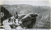
 Caption: "Glacier Point - Over Hanging Rock - Yosemite Falls In The Distance," c. 1935. A group of unidentified people looking out from Glacier Point. Both Upper and Lower Yosemite Fall are visible across the valley at the right side of the photograph. Glacier Point, on the south wall of the valley 3,200 feet above what is now known as Half Dome Village, provides panoramic views of the valley and many of its features. By the time this photograph was taken, safety railings had been installed at the Point to prevent visitors from tumbling over the cliff while trying to get the best views.
-
 McCarthy Album 09, Photograph 278
 Caption: "El Portal," c. 1917. Grace McCarthy poses with two unidentified people in front of the Hotel del Portal (or Del Portal Hotel) in El Portal, California. The resort hotel was constructed in 1908 by the Yosemite Terminal Company, a subsidiary of the Yosemite Valley Railroad Company, to provide accommodations for visitors to the park who arrived by train. The hotel burned to the ground in late October of 1917.
-
 McCarthy Album 09, Photograph 277
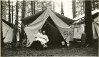
 Caption: "Life At Camp Curry," c. 1917. Two unidentified people pose in front of their tent at Camp Curry. An arrow points to an enameled pail just inside the tent, labeled "For Use in Case of Fire." Yosemite's Half Dome Village, established by David and Jennie Curry in 1899, was originally called Camp Curry, and then later Curry Village. It was designed to provide cheaper accommodations for Yosemite tourists than the resort hotels. The couple set up furnished tents and provided amenities such as a dining tent. As attendance at the park increased, the couple constructed more facilities with more modern amenities. In 2016, as a result of a legal dispute over trademarked names in the park, Curry Village changed its name to Half Dome Village.
-
 McCarthy Album 09, Photograph 276
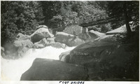
 Caption: "Foot Bridge," c. 1917. A pedestrian bridge spans the Merced River as it tumbles over and through chunks of granite and rock in Yosemite National Park.
-
 McCarthy Album 09, Photograph 275
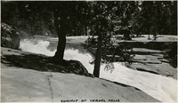
 Caption: "Summit of Vernal Falls," c. 1917. The Merced River begins its cascade over Vernal Fall in this photograph.
-
 McCarthy Album 09, Photograph 274
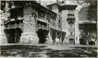
 No caption. William McCarthy stands in front of the Ahwahnee Hotel in Yosemite National Park, c. 1935. Opened in 1927 and designed by architect Gilbert Stanley Underwood, the Ahwahnee Hotel is located on the floor of Yosemite Valley. It was built as a resort hotel by the Yosemite Park and Curry Company. Modernized over the years, its name was changed to the Majestic Yosemite Hotel in 2016, as a result of legal dispute over trademarked names in the park.
-
 McCarthy Album 09, Photograph 273
 Caption: "Half Dome," c. 1917. The iconic granite Half Dome rises above the Yosemite Valley. This photograph appears to have been taken from across the Valley.
-
 McCarthy Album 09, Photograph 272
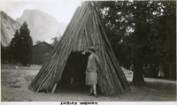
 Caption: "Indian Wigwam," c. 1917. Grace McCarthy poses at the entrance to what William McCarthy labeled a "wigwam," a dwelling of the Ahwahnechee people. The Ahwahnechee (a Native American tribe who traditionally occupied the Yosemite Valley) called the dwellings o-chum. Pine branches were arranged in a tee-pee-like shape and then covered with layered slabs of cedar bark.
-
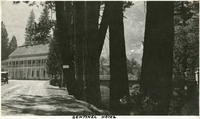 McCarthy Album 09, Photograph 271
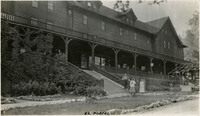
 Caption: "Sentinel Hotel," c. 1917. The Sentinel Hotel at Yosemite Village. Construction of this hotel began in 1876, and at the turn of the century it was the only hotel operating in the valley. Increased attendance as the twentieth century progressed resulted in the construction of other tourist areas such as Curry Village, and the Sentinel gradually became obsolete. The Sentinel and the complex of buildings that had grown up around it were torn down in the late 1930s.
-
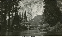 McCarthy Album 09, Photograph 270
 Caption: "Sentinel Hotel," c. 1917. The Sentinel Hotel at Yosemite Village, with a granite cliff in the background and the Merced River in the foreground. Construction of the hotel began in 1876, and at the turn of the century it was the only hotel operating in the valley. Increased attendance as the twentieth century progressed resulted in the construction of other tourist areas such as Curry Village, and the Sentinel gradually became obsolete. The Sentinel and the complex of buildings that had grown up around it were torn down in the late 1930s.
-
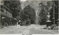 McCarthy Album 09, Photograph 269
 Caption: "The Village," c. 1917. Street scene in the Yosemite Village, the most developed part of the Yosemite Valley. The Village is home to such amenities as a Post Office, store, medical clinic, fire station, and restaurants. Development began at the site in 1865, but most of the buildings were constructed after 1918.
-
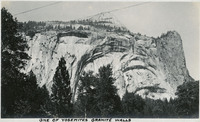 McCarthy Album 09, Photograph 268
 Caption: "One of Yosemite's Granite Walls," c. 1917. View of a granite wall carved by glaciers and shaped by water, wind, and rock falls, in the Yosemite Valley.
-
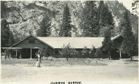 McCarthy Album 09, Photograph 267
 Caption: "Currys Garage," c. 1917. Grace McCarthy poses in front of Curry's Garage, a long, low building with bays at either end for vehicles.
-
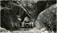 McCarthy Album 09, Photograph 266
 Caption: "Arched Rock- Merced River Drive - Yosemite.," c. 1917. Grace and William McCarthy (to right of the car) pose with their vehicle and an unidentified woman underneath the arched rock on what is now Highway 140, the El Portal Road. The area is now known as the Arched Rock Entrance to Yosemite Valley.
-
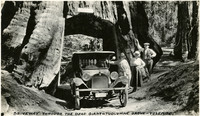 McCarthy Album 09, Photograph 265
 Caption: "Driveway Through the Dead Giant - Tuolumne Grove - Yosemite," c. 1917. Grace (next to automobile) and William (far right) McCarthy pose with their vehicle and an unidentified woman in the tunnel of "The Dead Giant," the remains of a giant sequoia in the Tuolumne Grove. The tunnel was cut into the trunk in 1878.
-
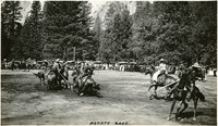 McCarthy Album 09, Photograph 264
 Caption: "Potato Race," c. 1917. Several horseback riders holding long poles skirmish around a bucket in what appears to be a game similar to polo, played with a potato. A crowd has gathered to watch the game, while the rock cliff walls of Yosemite Valley tower in the background. Given the date, this was likely part of Independence Day festivities in the Yosemite Valley.
-
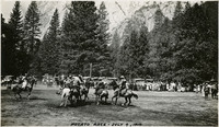 McCarthy Album 09, Photograph 263
 Caption: "Potato Race - July 4, 1917." Several horseback riders holding long poles skirmish in what appears to be a game similar to polo, played with a potato. A crowd has gathered to watch the game, while the rock cliff walls of Yosemite Valley tower in the background. Given the date, this was likely part of Independence Day festivities in the Yosemite Valley.
-
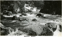 McCarthy Album 09, Photograph 262
 Caption: "Happy Isles," c. 1917. The Merced River tumbles over rocks and around several small isles in this photograph. The isles are collectively known as the Happy Isles.
-
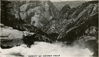 McCarthy Album 09, Photograph 261
 Caption: "Summit of Nevada Falls [sic]," c. 1917. View from the top of Nevada Fall into Yosemite Valley.
-
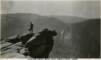 McCarthy Album 09, Photograph 260
 Caption: "Glacier Point - 3000 Feet Above Camp Curry," c. 1917. William McCarthy poses atop Glacier Point, overlooking Yosemite Valley. Glacier Point, on the south wall of the valley 3,200 feet above what is now known as Half Dome Village, provides panoramic views of the valley and many of its features.
-
 McCarthy Album 09, Photograph 259
 Caption: "On The Hike To Vernal Falls [sic]," c. 1917. William McCarthy poses for a photograph on the trail to Vernal Fall in this photograph.
-
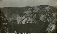 McCarthy Album 09, Photograph 258
 Caption: "Mountains in Yosemite," c. 1917. View of rock cliffs and domes in the mountains surrounding Yosemite Valley.
-
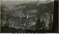 McCarthy Album 09, Photograph 257
 Caption: "Vernal and Nevada Falls - View From Glacier Point," c. 1917. Both Vernal Fall (bottom center) and Nevada Fall (middle) are observable from this vantage point at Glacier Point.
-
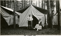 McCarthy Album 09, Photograph 256
 Caption: "Mirror Lane - Camp Curry," c. 1917. William and Grace McCarthy pose in front of their tent at what was then called Camp Curry. Yosemite's Half Dome Village, established by David and Jennie Curry in 1899, was originally called Camp Curry, and then later Curry Village. It was designed to provide cheaper accommodations for Yosemite tourists than the resort hotels. The couple rented out furnished tents and provided amenities such as a dining tent. As time progressed, the amenities increased, and some hard-sided cabins created.
-
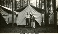 McCarthy Album 09, Photograph 255
 Caption: "Mirror Lane - Camp Curry," c. 1917. William and Grace McCarthy pose in front of their tent at what was then called Camp Curry. Yosemite's Half Dome Village, established by David and Jennie Curry in 1899, was originally called Camp Curry, and then later Curry Village. It was designed to provide cheaper accommodations for Yosemite tourists than the resort hotels. The couple rented out furnished tents and provided amenities such as a dining tent. As time progressed, the amenities increased, and some hard-sided cabins created.
-
 McCarthy Album 09, Photograph 254
 Caption: "Camp Curry- Yosemite," c. 1917. Yosemite's Half Dome Village, established by David and Jennie Curry in 1899, was originally called Camp Curry, and later Curry Village. It was designed to provide cheaper accommodations for Yosemite tourists than the resort hotels. The couple rented out furnished tents and provided amenities such as a dining tent. As time progressed, the amenities increased, and some hard-sided cabins created. This photograph shows a bustling scene around a large wood cabin with a wide covered porch. As a result of a legal dispute over trademarked names in the park, Curry Village changed its name to Half Dome Village in 2016.
-
 McCarthy Album 09, Photograph 253
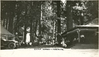
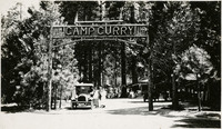
 No caption c. 1917. Grace McCarthy and two unidentified people pose under a log sign reading "Camp Curry." Yosemite's Half Dome Village, established by David and Jennie Curry in 1899, was originally called Camp Curry, and later Curry Village. It was designed to provide cheaper accommodations for Yosemite tourists than the resort hotels. The couple set up furnished tents and provided amenities such as a dining tent. The entrance sign seen in this photograph was erected in 1914. As a result of a legal dispute over trademarked names in the park, Curry Village changed its name to Half Dome Village in 2016.
-
 McCarthy Album 09, Photograph 252
 Caption: "Vernal Falls [sic]," c. 1917. The Merced River tumbles over and around large chunks of rock in this photograph, with Vernal Fall visible in the distance.
-
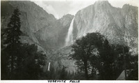 McCarthy Album 09, Photograph 251
 Caption: "Yosemite Falls," c.1917. Both the Upper and Lower Yosemite Falls, on Yosemite Creek, are visible in this photograph, taken from the valley floor. The highest waterfall in Yosemite National Park, Yosemite Falls is made up of two successive cascades falling a total of 2,425 feet from the top of the Upper Fall to the base of the Lower Fall. The Upper Fall alone is 1,430 feet high, and is one of the top twenty highest waterfalls in the world.
-
 McCarthy Album 09, Photograph 250
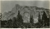
 Caption: "Yosemite," c. 1917. Yosemite's iconic Half Dome, a granite rock formation, as seen from the valley floor.
-
 McCarthy Album 09, Photograph 249
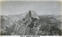
 Caption: "Half Dome - Yosemite," c. 1917. The iconic granite Half Dome rises above the Yosemite Valley. This photograph appears to have been taken from a neighboring peak.
-
 McCarthy Album 09, Photograph 248
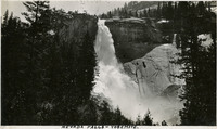
 Caption: "Nevada Falls [sic]," c. 1917. Nevada Fall is a 594-foot high waterfall upstream of Vernal Fall on the Merced River, in the Little Yosemite Valley.
-
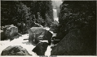
 McCarthy Album 09, Photograph 247
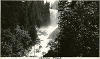
 Caption: "Vernal Falls [sic]," c. 1917. Vernal Fall is a 317-foot waterfall on the Merced River, downstream of Nevada Fall.
-
 McCarthy Album 09, Photograph 246
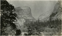
 Caption: "Yosemite," c. 1917. View of the Yosemite Valley.
-
 McCarthy Album 09, Photograph 245
 Caption: "Yosemite," c. 1917. View of Yosemite Valley, taken from the valley floor, with Half Dome rising at the right. .
-
 McCarthy Album 09, Photograph 244
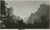
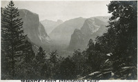
 Caption: "Yosemite - From Inspiration Point," c. 1917. The Yosemite Valley, showing El Capitan (left middle distance), Cathedral Rocks (right middle distance), and Half Dome (far distance in the center).
-
 McCarthy Album 09, Photograph 243a
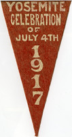
 No caption. Red pennant with white writing reading "Yosemite Celebration of July 4th 1917."
-
 McCarthy Album 09, Photograph 243
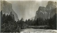
 Caption: "Yosemite.," c. 1920. View of the Yosemite Valley from the valley floor, with the Merced River in the foreground, and El Capitan (left) and the Cathedral Rocks (right) in the background. Bridalveil Fall cascades down a cliff face beneath the Cathedral Rocks.
-
 McCarthy Album 09, Photograph 242
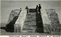
 Caption: "Maricopa Point - Grand Canyon of Arizona," c. 1925. Erroneously labeled, this photograph shows Grace McCarthy standing at the Powell Memorial on Powell Point, rather than Maricopa Point. The granite Powell Memorial commemorates John Wesley Powell, who explored the Colorado River in 1869 and 1872. The 1869 expedition included the first known descent of a person of European ancestry into the Grand Canyon.
-
 McCarthy Album 09, Photograph 241
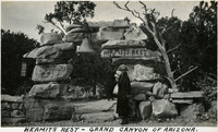
 Caption: "Hermits Rest - Grand Canyon," c. 1925. Grace McCarthy poses at the entry arch of Hermit's Rest at the Grand Canyon in Arizona. Hermit's Rest, a rest area for tourists, is located on the Grand Canyon's south rim, at the westernmost point accessible by paved road.
-
 McCarthy Album 09, Photograph 240
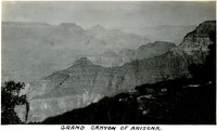
 Caption: "Grand Canyon of Arizona," c. 1925. Bird's eye view of part of the Grand Canyon in Arizona, on the Colorado River.