-
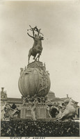 McCarthy Album 07, Photograph 015
 Caption: "Statue of Energy," The Fountain of Energy (A. Stirling Calder, sculptor), with surrounding statuary at the Panama-Pacific International Exposition. See also 96-07-08-alb01-010.
-
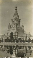 McCarthy Album 07, Photograph 014
 Caption: "Panama Pac. International Exposition." A view of the Tower of Jewels with reflecting pool at the Panama-Pacific International Exposition.
-
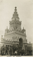 McCarthy Album 07, Photograph 013
 Caption: "Tower of Jewels," at the Panama-Pacific International Exposition. The Panama Pacific International Exposition was held to celebrate the completion of the Panama Canal, as well as inventive technologies and new industries from around the world. It was also a chance for San Francisco to show the world how the great city had rebuilt and thrived after the devastation of the 1906 earthquake and fire.
-
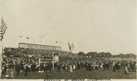 McCarthy Album 07, Photograph 012
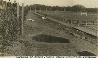
 Caption: "Breaking of Ground Celebration," Oct 14, 1911, held in San Francisco for the planned Panama-Pacific International Exposition, which was slated to open in 1915. The Panama Pacific International Exposition was held to celebrate the completion of the Panama Canal, as well as inventive technologies and new industries from around the world. It was also a chance for San Francisco to show the world how the great city had rebuilt and thrived after the devastation of the 1906 earthquake and fire.
-
 McCarthy Album 07, Photograph 011
 Caption: "Breaking of Ground, Panama-Pacific International Exposition." See also 96-07-08-alb01-006, which includes the same caption. San Francisco, Oct 14, 1911. The 1915 Panama Pacific International Exposition was held to celebrate the completion of the Panama Canal, as well as inventive technologies and new industries from around the world. It was also a chance for San Francisco to show the world how the great city had rebuilt and thrived after the devastation of the 1906 earthquake and fire.
-
 McCarthy Album 07, Photograph 010
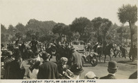
 Caption: "President Taft in Golden Gate Park." See also 96-07-08-alb01-004, with caption: "President Taft in the Park." October 14, 1911. President William Howard Taft in San Francisco's Golden Gate Park during the groundbreaking ceremony for the Panama-Pacific International Exposition, which was slated to open January 1915.
-
 McCarthy Album 07, Photograph 009
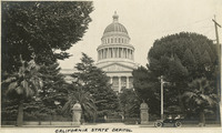
 Caption: "California State Capitol." Shows the California State Capitol building and grounds. Located on the west end of Capitol Park, the neoclassical building's construction began in 1860 and was completed in 1874. It houses the state legislature and offices of the governor. The capitol and grounds were listed on the National Register of Historic Places in 1973, and as a California Historical Landmark in 1974. A parked automobile in the foreground has Grace McCarthy at the wheel, with William McCarthy sitting beside her, and two unidentified people in the backseat, Sacramento, c. 1915.
-
 McCarthy Album 07, Photograph 008
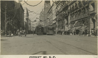
 Caption: "Market St. S.F." Shows Market Street in San Francisco, possibly during a parade to celebrate Admission Day on September 9, when California was admitted as a state into the U.S. See also 96-07-08-alb05-136, with caption: "Market St. Sept 9, 1910 S.F."
-
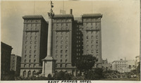 McCarthy Album 07, Photograph 007
 Caption: "Saint Francis Hotel." See also 96-07-08-alb01-002, with caption: "Hotel-Saint Francis," c. 1913. St. Francis Hotel at Union Square with partial north wing extension and the Dewey Monument in the foreground (Robert I. Aitken, sculptor), which commemorated U.S. Admiral George Dewey's naval victory at the battle of Manila Bay during the Spanish American War of 1898. The luxury hotel opened in 1904 and, fortunately, suffered little damage from the 1906 earthquake. It was expanded in 1913, and 1972, making it one of the largest hotels in the city.
-
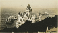 McCarthy Album 07, Photograph 006
 Caption: "Cliff House #2." View of the third Cliff House, of Victorian-style architecture, that was built on that site in San Francisco, c. 1906. The original Cliff House was built in 1858. The second was built in 1863 and was destroyed by fire on Christmas day in 1894. The third Victorian- style Cliff House (pictured) was completed in 1896, and although it survived the 1906 earthquake and fires, it burned to the ground in 1907. A fourth Cliff House was then built with steel-reinforced concrete and opened in 1909.
-
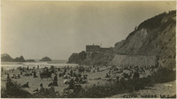 McCarthy Album 07, Photograph 005
 Caption: " Cliff House #3." View of people on Ocean Beach and walking up the road to the (fourth) Cliff House in the distance, San Francisco, c. 1910. The original Cliff House was built in 1858. The second was built in 1863 and was destroyed by fire on Christmas day in 1894. The third Victorian- style Cliff House was completed in 1896, and although it survived the 1906 earthquake and fires, it burned to the ground in 1907. A fourth Cliff House (pictured) was then built with steel-reinforced concrete and opened in 1909.
-
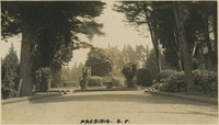 McCarthy Album 07, Photograph 004
 Caption: "Presidio S.F." See also 96-07-08-alb02-021. Entrance to the main post of the Presidio, San Francisco, c. 1910. Established in 1776 by Spanish explorers, the Presidio is a fortified location overlooking the Golden Gate, the entrance into San Francisco Bay. It was closed as a military structure in 1995, and is now a park within the Golden Gate National Recreation Area.
-
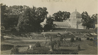 McCarthy Album 07, Photograph 003
 Caption: "Conservatory Golden Gate Park," c. 1910. See also 96-07-08-alb03-006, and 96-07-08-alb02-014. The Conservatory of Flowers in Golden Gate Park, San Francisco, originally opened in 1879. After the most recent extensive rehabilitation, the conservatory reopened in 2003 and is a city, state, and national historic landmark.
-
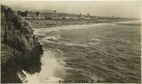 McCarthy Album 07, Photograph 002
 Caption: "Cliff Beach." Shows views of Ocean Beach near the Cliff House in San Francisco, c. 1910.
-
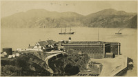 McCarthy Album 07, Photograph 001
 Caption: "Fort Point." c. 1906. See also 96-07-08-alb06-009 with caption: "Fort Point and Golden Gate," and 96-07-08-alb03-118, San Francisco. Fort Point in the foreground, with ships in the bay. Fort Point was part of an effort by the U.S. government to protect the Golden Gate, entrance to the San Francisco Bay. Built between 1853-1861 of brick and mortar, the fort included emplacements for 141 guns but never fired a weapon in defense of the Bay.
-
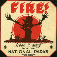 McCarthy Album 09, Photograph 321b
 This warning sticker advertises "FIRE! Keep it away form our National Parks." The silhouette of a skeletal tree stretches bare branches toward the viewer.
-
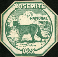 McCarthy Album 09, Photograph 321a
 A green and white decal commemorating a visit to Yosemite National Park in 1928, featuring a mountain lion against a stylized sketch of Half Dome.
-
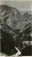
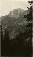 McCarthy Album 09, Photograph 321
 No Caption. Mountain scene at Yosemite National Park, c. 1917.
-
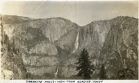 McCarthy Album 09, Photograph 320
 Caption: "Yosemite Falls - View From Glacier Point," c. 1917. Yosemite Falls in the distance, as seen from Glacier Point. The highest waterfall in Yosemite National Park, Yosemite Falls is made up of two successive cascades falling a total of 2,425 feet from the top of the Upper Fall to the base of the Lower Fall. The Upper Fall alone is 1,430 feet high, and is one of the top twenty highest waterfalls in the world.
-
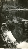
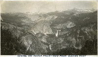 McCarthy Album 09, Photograph 319
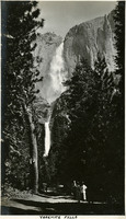
 Caption: "Vernal and Nevada Falls - View From Glacier Point," c. 1917. Example of the spectacular views available from Glacier Point on the south wall of the Yosemite Valley. Vernal and Nevada Falls can be seen in the distance.
-
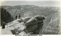 McCarthy Album 09, Photograph 318
 Caption: "Glacier Point - Overhanging Rock," c. 1935. Grace McCarthy poses for a photograph at Glacier Point's iconic overhanging rock. Glacier Point, on the south wall of the valley 3,200 feet above what is now known as Half Dome Village, provides panoramic views of the valley and many of its features. By the time this photograph was taken, safety railings had been installed at the Point to prevent visitors from tumbling over the cliff while trying to get the best views.
-
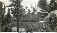 McCarthy Album 09, Photograph 317
 Caption: "Glacier Point Hotel," c. 1917. The 80-room chalet-style Glacier Point Hotel opened in 1918, located 3,218 feet above the floor of Yosemite Valley on Glacier Point. This photograph shows the back side of the building, with a viewing porch that looked out over the valley. The building was destroyed by an electrical fire in July 1969.
-
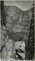 McCarthy Album 09, Photograph 316
 Caption: "Yosemite Falls - View From Ledge Trail," c. 1917. Yosemite Falls in the distance, as seen from across the valley on the Ledge Trail above Half Dome Village. The highest waterfall in Yosemite National Park, Yosemite Falls is made up of two successive cascades falling a total of 2,425 feet from the top of the Upper Fall to the base of the Lower Fall. The Upper Fall alone is 1,430 feet high, and is one of the top twenty highest waterfalls in the world.
-
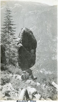 McCarthy Album 09, Photograph 315
 Caption: "Balance Rock," c. 1917. Grace McCarthy poses in front a massive boulder balanced on its tip, appearing ready to fall over at any moment.
-
 McCarthy Album 09, Photograph 314
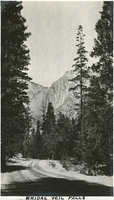
 Caption: "Bridal Veil Falls [sic]," c. 2017. The 617-foot-tall Bridalveil Fall, one of the iconic natural wonders of Yosemite National Park.
-
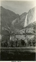
 McCarthy Album 09, Photograph 313
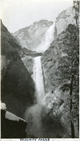
 Caption: "Yosemite Falls," c. 1917. Both Upper and Lower Yosemite Falls can be seen in this photograph, taken at a location near the base of Lower Yosemite Fall. The highest waterfall in Yosemite National Park, it is made up of two successive cascades falling a total of 2,425 feet from the top of the Upper Fall to the base of the Lower Fall. The Upper Fall alone is 1,430 feet high, and is one of the top twenty highest waterfalls in the world.
-
 McCarthy Album 09, Photograph 312
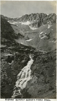
 Caption: "Sierra Summit Scene - Tioga Pass," c. 1917. Patches of snow litter the walls of Tioga Pass, while a small stream cascades down the hillside. California State Route 120 runs through the pass, providing an eastern entry into Yosemite National Park.
-
 McCarthy Album 09, Photograph 311
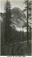
 Caption: "Scene On The Tioga Road," c. 1917. In a photograph taken from the Tioga Road, a massive granite dome rises above the trees in Yosemite National Park.
-
 McCarthy Album 09, Photograph 310
 Caption: "Bridal Veil [sic] Falls," c. 1917. A road winds through trees while Bridalveil Fall cascades down the south wall of Yosemite Valley in the distance.
-
 McCarthy Album 09, Photograph 309
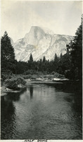
 Caption: "Half Dome," c. 1917. The Merced River flows through the photograph in the foreground, while the iconic Half Dome looms in the background.
-
 McCarthy Album 09, Photograph 308
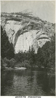
 Caption: "Granite Formation," c. 1917. A granite wall towers above the Merced River in this photograph of a portion of the Yosemite Valley.
-
 McCarthy Album 09, Photograph 307
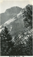
 Caption: "Glacier Point (x)," c. 1917. In this photograph of the walls of Yosemite Valley, taken from the valley floor, William McCarthy has marked the location of Glacier Point with an "x." Glacier Point, on the south wall of the valley 3,200 feet above what is now known as Half Dome Village, provides panoramic views of the valley and many of its features.
-
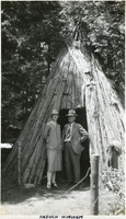 McCarthy Album 09, Photograph 306
 Caption: "Indian Wigwam," c. 1935. William and Grace McCarthy pose at the entrance to what William labeled a "wigwam," a dwelling of the Ahwahnechee people. The Ahwahnechee (a Native American tribe who traditionally occupied the Yosemite Valley) called the dwellings o-chum. Pine branches were arranged in a tee-pee-like shape and then covered with layered slabs of cedar bark.
-
 McCarthy Album 09, Photograph 305
 Caption: "Sunrise - Mirror Lake - Yosemite," c. 1917. A reflection of a sunrise on Mirror Lake. The lake, fed by Tenaya Creek, is the remains of a glacial lake that used to fill most of the valley. Its calm waters provide near-perfect reflections of the surrounding natural splendor.
-
 McCarthy Album 09, Photograph 304
 Caption: "Cascade Falls," c. 1917. Erroneously labeled as Cascade Falls, this photograph actually shows both the Upper and Lower Yosemite Falls as viewed from the floor of Yosemite Valley. The highest waterfall in Yosemite National Park, Yosemite Falls is made up of two successive cascades falling a total of 2,425 feet from the top of the Upper Fall to the base of the Lower Fall. The Upper Fall alone is 1,430 feet high, and is one of the top twenty highest waterfalls in the world.
-
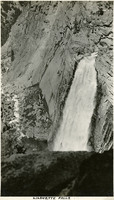 McCarthy Album 09, Photograph 303
 Caption: "Lilouette [sic] Falls," c. 1917. Illilouette Falls is a 370-foot waterfall in Yosemite located on the Illilouette Creek, a small tributary of the Merced River. The photograph was taken from a point above the summit of the falls.
-
 McCarthy Album 09, Photograph 302
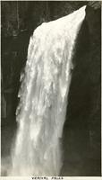
 Caption: "Vernal Falls [sic]," c. 1917. Closeup view of Vernal Fall, a 317-foot waterfall on the Merced River, downstream of Nevada Fall.
-
 McCarthy Album 09, Photograph 301
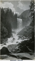
 Caption: "Vernal Falls [sic]," c. 1917. The Merced River tumbles over boulders downstream of the 317-foot tall cascade of Vernal Fall.
-
 McCarthy Album 09, Photograph 300
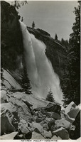
 Caption: "Nevada Falls [sic] - Yosemite," c. 1917. Nevada Fall is a 594-foot high waterfall upstream of Vernal Fall on the Merced River, in the Little Yosemite Valley. This photograph, taken at a point next to the fall's path of descent, shows the upper portion of the fall.
-
 McCarthy Album 09, Photograph 299
 Caption: "Yosemite Falls," c. 1917. Grace McCarthy two unidentified friends pose for a photograph on the trail to Yosemite Falls. Both Upper and Lower Fall can be seen in this photograph. The highest waterfall in Yosemite National Park, Yosemite Falls is made up of two successive cascades falling a total of 2,425 feet from the top of the Upper Fall to the base of the Lower Fall. The Upper Fall alone is 1,430 feet high, and is one of the top twenty highest waterfalls in the world.
-
 McCarthy Album 09, Photograph 298
 Caption: "Mountain Scene - Yosemite," c. 1917. Granite cliffs and evergreen trees dominate this photograph.
-
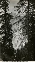 McCarthy Album 09, Photograph 297
 Caption: "Towering Trees and Cliffs - Yosemite," c. 1917. View of a granite mountain top as viewed through trees on a neighboring peak.
-
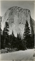 McCarthy Album 09, Photograph 296
 Caption: "El Capitan," c. 1917. El Capitan is a vertical granite rock formation in Yosemite Valley. It's sheer cliff face, rising almost 3,000 feet above the Valley, is a favorite rock climbing location.
-
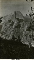 McCarthy Album 09, Photograph 295
 Caption: "Half Dome," c. 1917. The iconic granite Half Dome rises above the Yosemite Valley in this photograph, taken from a neighboring peak.
-
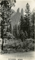 McCarthy Album 09, Photograph 294
 Caption: "Cathedral Spires," c. 1917. Rock formation known as Cathedral Spires in Yosemite National Park, as seen from the valley floor through trees.
-
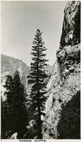 McCarthy Album 09, Photograph 293
 Caption: " Rugged Cliffs," c. 1917. View of a sheer cliff face with rocky, timbered mountains beyond.
-
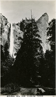 McCarthy Album 09, Photograph 292
 Caption: "Bridal Veil [sic] and Leaning Tower," c. 1917. Bridalveil Fall and the adjacent Leaning Tower, a popular rock climbing destination within Yosemite National Park.
-
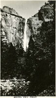 McCarthy Album 09, Photograph 291
 Caption: "Bridal Veil Falls [sic]," c. 2017. The 617-foot-tall Bridalveil Fall, one of the iconic natural wonders of Yosemite National Park.
-
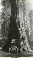 McCarthy Album 09, Photograph 290
 Caption: "California," c, 1917. The McCarthy's vehicle is squeezed into the tunnel carved through the California Tree, a Giant Sequoia in the Mariposa Grove of Yosemite National Park. The tunnel was cut through the tree in 1895 to facilitate travel on the road into the grove, and also as a tourist attraction. It is now the only living Giant Sequoia with a tunnel cut through it (so-called "tunnel trees"), the others having all fallen.
-
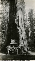 McCarthy Album 09, Photograph 289
 Caption: "California - Living Giant - Mariposa Grove," c. 1917. William and Grace McCarthy, with an unidentified friend, pose with their vehicle in the tunnel through the California Tree, a Giant Sequoia in the Mariposa Grove of Yosemite National Park. The tunnel was cut through the tree in 1895 to facilitate travel on the road into the grove, and also as a tourist attraction. It is now the only living Giant Sequoia with a tunnel cut through it (so-called "tunnel trees"), the others having all fallen.