-
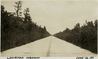 McCarthy Album 11, Photograph 039
 Caption: "Louisiana Highway, June 12, 34." A highway in Louisiana recedes into the distance, flanked by tall vegetation.
-
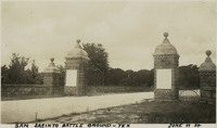 McCarthy Album 11, Photograph 038
 Caption: "San Jacinto Battle Ground -- Tex, June 11 34." View of the gated entry to the San Jacinto Battleground. The site was the location of the Battle of San Jacinto, in which the Texan Army (led by Sam Houston) defeated the Mexican army (led by General Antonio López de Santa Anna), paving the way for the formation of the Republic of Texas. A Texas Historic Site, the battleground was also declared a National Historic Landmark in 1960.
-
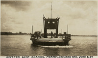 McCarthy Album 11, Photograph 037
 Caption: "Houston Ship Channel Ferry -- Houston Tex. June 9, 34." View of a ferry with a single vehicle on board, crossing the Houston Ship Channel. The dredged channel was opened in 1914 as part of the Port of Houston.
-
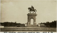 McCarthy Album 11, Photograph 036
 Caption: "Sam Houston Monument -- Houston Tex. June 8, 34." View of the San Houston Monument, a twenty-foot-tall bronze sculpture designed by Enrico Cerracchio and dedicated in 1925. The sculpture commemorates Sam Houston, a prominent soldier and politician who served as the first and third President of the Republic of Texas before its annexation to the U.S. Houston also served as Governor of Texas and as a U.S. Senator for both Texas and Tennessee.
-
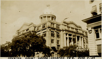 McCarthy Album 11, Photograph 035
 Caption: "Houston Court House -- Houston Tex. June 7, 34." View of the Harris County Courthouse, a neoclassical building constructed in 1910 and designed by Dallas architectural firm Lang & Witchell. It was the fifth courthouse to be built on the site.
-
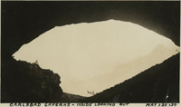 McCarthy Album 11, Photograph 034
 Caption: "Carlsbad Caverns -- Inside Looking Out, May, 30, 34." View looking out of the mouth of Carlsbad Cavern, a series of natural underground chambers including the "Big Room," the fifth-largest such chamber in North America with a length of 1,000 feet, a width of 625 feet, and a maximum height of 255 feet. The site was named Carlsbad Cave National Monument in 1923, and declared Carlsbad Caverns National Park in 1930.
-
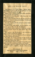 McCarthy Album 11, Photograph 033b
 One side of a flier handed out by the San Antonio Reptile Garden in the mid-1930s entitled "Reptile Facts." The Reptile Garden opened in the 1930s as a fundraising facility for the Witte Museum. The Garden featured turtle races, snake handling demonstrations, fried rattlesnake meat, and rattlesnake dinner fund raisers. It also became a research center for the use of antivenom. The Garden closed in the early 1940s, its live snakes donated to the San Antonio Zoo.
-
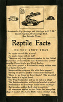 McCarthy Album 11, Photograph 033a
 One side of a flier handed out by the San Antonio Reptile Garden in the mid-1930s entitled "Reptile Facts." The Reptile Garden opened in the 1930s as a fundraising facility for the Witte Museum. The Garden featured turtle races, snake handling demonstrations, fried rattlesnake meat, and rattlesnake dinner fund raisers. It also became a research center for the use of antivenom. The Garden closed in the early 1940s, its live snakes donated to the San Antonio Zoo.
-
 McCarthy Album 11, Photograph 033
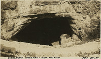
 Caption: "Carlsbad Caverns -- New Mexico, May 30, 34." View looking into dark cave mouth of Carlsbad Cavern, a series of natural underground chambers including the "Big Room," the fifth-largest such chamber in North America with a length of 1,000 feet, a width of 625 feet, and a maximum height of 255 feet. The site was named Carlsbad Cave National Monument in 1923, and declared Carlsbad Caverns National Park in 1930.
-
 McCarthy Album 11, Photograph 032
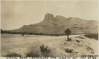
 Caption: "Signal Peak -- Guadalupe Mts. 10,000 ft alt. New Mexico, May 29, 34." View of Guadalupe Peak (also known as Signal Peak), the highest natural point in Texas with an elevation of 8,751 feet above sea level.
-
 McCarthy Album 11, Photograph 031
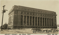
 Caption: "Court House -- El Paso Tex. Population of El Paso 100,000, 80% Mexicans. 4000 ft. alt. May 28, 34." View of the El Paso County Courthouse, built in 1917 and designed by Henry Charles Trost. It is not known where William McCarthy got the statistics he quotes in the caption.
-
 McCarthy Album 11, Photograph 030
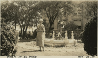
 Caption: "Park in El Paso, May 27, 34." Grace McCarthy standing in a park, in front of statue of a young boy.
-
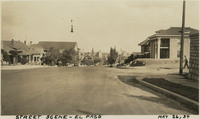 McCarthy Album 11, Photograph 029
 Caption: "Street Scene -- El Paso, May 26, 34." Street scene in El Paso, Texas. Residences line the street in the foreground, while what appears to be a city center can be seen in the center distance.
-
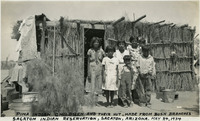 McCarthy Album 11, Photograph 028
 Caption: "Pima Indian Children and Their Hut, Made from Bush Branches, Sacaton Indian Reservation, Sacaton, Arizona. May 24, 1934." Several children of the Akimel O'odham (Pima) tribe in front of a hut made with tree branches and wood beams, its walls and roof thatched in brush. Located south of Phoenix and including the town of Sacaton, the Gila River Indian Reservation is home to members of the Akimel O’odham (Pima) and the Pee-Posh (Maricopa) tribes. The reservation was established in 1859. Eighty years later, in 1939, Congress provided for the self-governance of the reservation via the Gila River Indian Community.
-
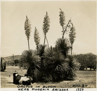 McCarthy Album 11, Photograph 027
 Caption: "Cactus in Bloom Near Phoenix Arizona, May 24 1934." Cluster of what appear to be yucca plants in bloom.
-
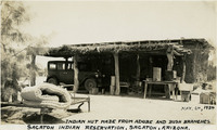 McCarthy Album 11, Photograph 026
 Caption: "Indian Hut Made From Adobe and Bush Branches, Sacaton Indian Reservation, Sacaton, Arizona, May, 24, 1934." View of a small adobe building with a porch area across the length of the façade. The porch is sheltered by a low roof supported by tree trunks or thick tree branches and thatched with grass or sticks. Located south of Phoenix and including the town of Sacaton, the Gila River Indian Reservation is home to members of the Akimel O’odham (Pima) and the Pee-Posh (Maricopa) tribes. The reservation was established in 1859. Eighty years later, in 1939, Congress provided for the self-governance of the reservation via the Gila River Indian Community.
-
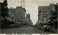 McCarthy Album 11, Photograph 025
 Caption: "Central St. Phoenix, Arizona. May 24, 1934." View from street-level of Phoenix's Central Street.
-
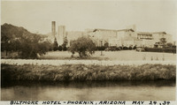 McCarthy Album 11, Photograph 024
 Caption: "Biltmore Hotel -- Phoenix, Arizona, May 24, 34." View of the Biltmore Hotel in Phoenix, part of the Bowman-Biltmore hotel chain. Designed by Albert Chase McArthur (with some collaboration from Frank Lloyd Wright), the hotel opened for business in 1929.
-
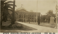 McCarthy Album 11, Photograph 023
 Caption: "State Capitol, Phoenix Arizona, May 24, 34." View of the façade of the Arizona State Capitol Building in Phoenix. Designed by James Riely Gordon, the building opened for use in 1901.
-
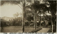 McCarthy Album 11, Photograph 022
 Caption: "The Casino -- Agua Caliente, Mexico -- May 20, 34." View of the exterior of the casino at Agua Caliente Casino and Resort. Designed by Wayne McAllister, the resort opened in Tijuana in 1928. It closed only a few years later, in 1935, when Mexican President Lázaro Cárdenas outlawed gambling.
-
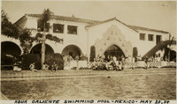 McCarthy Album 11, Photograph 021
 Caption: "Agua Caliente Swimming Pool -- Mexico -- May 20, 34." View of the swimming pool, with bathers and people socializing around the water, at Agua Caliente Casino and Resort. Designed by Wayne McAllister, the resort opened in Tijuana in 1928. It closed only a few years later, in 1935, when Mexican President Lázaro Cárdenas outlawed gambling.
-
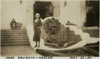 McCarthy Album 11, Photograph 020
 Caption: "Agua Caliente -- Mexico, May 20, 34." Grace McCarthy standing in front of a fountain at the Agua Caliente Casino and Resort. Designed by Wayne McAllister, the resort opened in Tijuana in 1928. It closed only a few years later, in 1935, when Mexican President Lázaro Cárdenas outlawed gambling.
-
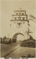 McCarthy Album 11, Photograph 019
 Caption: "Agua Caliente Mexico, May 20, 34." View of an elaborate large arch over a roadway, pointing the way to Hotel Agua Caliente in Tijuana. The Agua Caliente Casino and Resort Hotel, designed by Wayne McAllister, opened in Tijuana in 1928. The resort closed only a few years later, in 1935, when Mexican President Lázaro Cárdenas outlawed gambling.
-
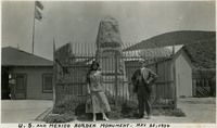 McCarthy Album 11, Photograph 018
 Caption: "U. S. and Mexico Border Monument. May 20, 1934." William and Grace McCarthy standing in front of the monument placed at the U.S.-Mexico border in Tijuana, Mexico.
-
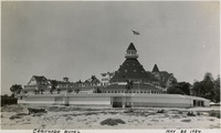 McCarthy Album 11, Photograph 017
 Caption: "Coronado Hotel, May 20, 1934." View of the Coronado Hotel, with sand dunes in the foreground. At the time it opened in 1888, this hotel was the largest beach resort in the world. The Ballroom Tower, the highest point of the building, is 120 feet tall.
-
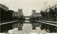 McCarthy Album 11, Photograph 016
 Caption: "Balboa Park, San Diego, Calif. May 19, 1934." View of an artificial lagoon in San Diego's Balboa Park, with the Panama-California Exposition's Commerce and Industries Building (tower at left, now called Casa de Balboa) and the Foreign Arts Building (tower at right, now called the House of Hospitality).
-
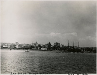 McCarthy Album 11, Photograph 015
 Caption: "San Diego Water Front, May 19, 1934." View from across the harbor of San Diego's waterfront.
-
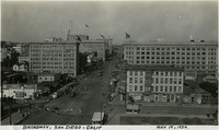 McCarthy Album 11, Photograph 014
 Caption: "Broadway, San Diego, Calif, May 19, 1934." Bird's eye view of Broadway, a main street in San Diego.
-
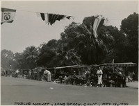 McCarthy Album 11, Photograph 013
 Caption: "Public Market, Long Beach, Calif, May 18, 1934." Small street market in Long Beach, showing a flower vendor, fruit or vegetable vendors, and a few other stalls too distant to make out the merchandise.
-
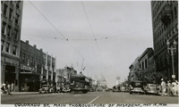 McCarthy Album 11, Photograph 012
 Caption: "Colorado St. Main Thoroughfare of Pasadena, May 18, 1934." Scene on Colorado Street in Pasadena.
-
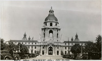 McCarthy Album 11, Photograph 011
 Caption: "City Hall, Pasadena, Cal. May 18, 1934." View of Pasadena's City Hall, designed by San Francisco firm Bakewell and Brown. Built in 1927, the building reflects the City Beautiful movement of that decade.
-
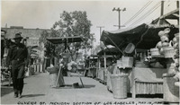 McCarthy Album 11, Photograph 010
 Caption: "Olvera St. Mexican Section of Los Angeles, May 18, 1934." View of the Olvera Street Market in Los Angeles. In 1926, Christine Sterling began efforts to preserve the buildings on and around Olvera Street (one of the oldest parts of Los Angeles). After several years of struggle and fundraising, Olvera Street was closed to automobile traffic in 1929, and opened as the Paseo de Los Angeles in 1930. The street and its market quickly became popular tourist sites, promoters touting the area as "A Mexican Street of Yesterday in a City of Today."
-
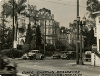 McCarthy Album 11, Photograph 009a
 Caption: "Chas Chaplin Residence Los Angeles, May 18, 1934." View of a castle-like building, with crenellated parapets and a tower. William McCarthy labeled this as a residence of Charlie Chaplin. The sign in front appears to indicate that the building is a church rather than a residence, but is difficult to read.
-
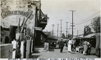 McCarthy Album 11, Photograph 009
 Caption: "Olvera St. Mexican Market Place, Los Angeles, May 18, 1934." View of the Olvera Street Market in Los Angeles. In 1926, Christine Sterling began efforts to preserve the buildings on and around Olvera Street (one of the oldest parts of Los Angeles). After several years of struggle and fundraising, Olvera Street was closed to automobile traffic in 1929, and opened as the Paseo de Los Angeles in 1930. The street and its market quickly became popular tourist sites, promoters touting the area as "A Mexican Street of Yesterday in a City of Today."
-
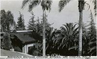 McCarthy Album 11, Photograph 008
 Caption: "Berheimer [sic] Brothers Japanese Garden, Los Angeles, May 18, 1934." View of a portion of the grounds of the mansion built by brothers Adolph and Eugene Bernheimer in 1914, in the Hollywood Hills area. Palm trees dominate the view, and an Asian-inspired outbuilding is visible at the left.
-
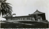 McCarthy Album 11, Photograph 007
 Caption: "Berheimer [sic] Brothers Japanese Type Home, Los Angeles, May 18, 1934." View of the mansion built by brothers Adolph and Eugene Bernheimer in 1914, in the Hollywood Hills area. Designed by Franklin Small, the form of the mansion is based upon a Japanese villa. It is now home to the Yamashiro restaurant and hotel.
-
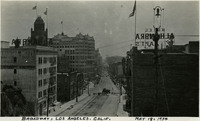 McCarthy Album 11, Photograph 006
 Caption: "Broadway, Los Angeles. Calif. May 18, 1934." Street scene showing a view of Broadway in Los Angeles. Hotel Alhambra is visible in the foreground on both sides of the street, while the clock tower of the Los Angeles County Courthouse is visible at the left.
-
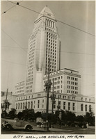 McCarthy Album 11, Photograph 005
 Caption: "City Hall, Los Angeles, May 18, 1934." View of Los Angeles' City Hall, built in 1928 and designed by architects John Parkinson, John C. Austin, and Albert C. Martin, Sr.
-
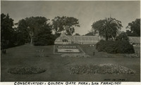 McCarthy Album 11, Photograph 004
 Caption: "Conservatory, Golden Gate Park, San Francisco, May 14, 1934." View of one wing of the Conservatory of Flowers in Golden Gate Park. A planting bed in front of the wing has been planted with flowers in such a way as to portray the California flag and the letters "California Diamond Jubilee, 1850-1925." The date on this photograph may not be accurate, given the dates included in the flower bed. The Conservatory of Flowers is the oldest building in Golden Gate Park, dating to 1879. The Victorian-style building has housed rare and exotic plants since its completion.
-
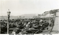 McCarthy Album 11, Photograph 003
 Caption: "Ocean Beach -- San Francisco, May 14, 1934." View of San Francisco's Ocean Beach, with a crowded parking lot in the foreground and the Cliff House (the fourth iteration of this San Francisco landmark) visible just to the right of the photograph's center. The date on this photograph may not be accurate, as several of the vehicles shown appear to date from later in the 1930s.
-
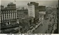 McCarthy Album 11, Photograph 002
 Caption: "Lower Market St. San Francisco, Calif., May 14, 1934." Bird's eye view of a street scene along San Francisco's Market Street. The Ferry Building is visible in the upper right-hand corner of the photograph, while the Flatiron Building appears in the photograph's center.
-
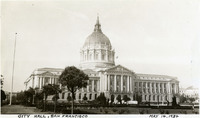 McCarthy Album 11, Photograph 001
 Caption: "City Hall, San Francisco, May 14, 1934." View of San Francisco's Beaux-Arts style City Hall (principle architect: Arthur Brown, Jr.). This building, opened in 1915, replaced San Francisco's original City Hall, which was destroyed in the 1906 earthquake and fire. The date with which the photograph was labeled (May 14, 1934) does not appear to be accurate. The date is more likely circa 1925. See also 96-07-08-alb09-003 and 005, and 96-07-08-alb10-01.
-
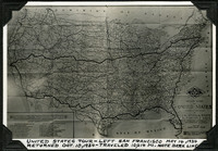 McCarthy Album 11, Photograph 001c
 Caption: "United States Tour -- Left San Francisco May 14, 1934, Returned Oct. 10, 1934 -- Traveled 10,014 Mi. Note Dark Line." This photograph of a roadmap published by the California State Automobile Association shows the route taken by William and Grace McCarthy on an automobile tour of the United States.
-
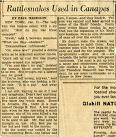 McCarthy Album 11, Photograph 001b
 This clipping from an unidentified newspaper or newsletter features an article by Paul Harrison called "Rattlesnakes Used in Canapes." It discusses the use of rattlesnake meat in a New York restaurant.
-
 McCarthy Album 11, Photograph 001a
 This clipping from an unidentified newspaper or newsletter features a 1946 article by A. L. Simon called "How To Run A Bridge." The article discusses the San Francisco-Oakland Bay Bridge, opened ten years before the article was written.
-
 McCarthy Album 07, Photograph 319
 Caption: "Benicia Arsenal Harem," c. 1918, shows a group of unidentified women wearing face masks at the Benicia Arsenal.
-
 McCarthy Album 07, Photograph 318
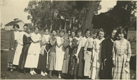
 No Caption: Shows a group of unidentified women posing on the grounds of the Benicia Arsenal, c. 1915.
-
 McCarthy Album 07, Photograph 317
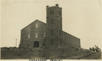
 Caption: "Storehouse Rebuilt," shows the reconstructed storehouse at the Benicia Arsenal, undated.
-
 McCarthy Album 07, Photograph 316
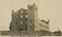
 Caption: "Benicia Arsenal Storehouse Ruins," c. 1915, shows some remaining walls of the Benicia Arsenal storehouse, which suffered damage from a 1912 explosion.
-
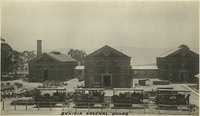 McCarthy Album 07, Photograph 315
 Caption: "Benicia Arsenal Shops," c. 1915, shows three large structures surrounded by assorted machinery and equipment at the Benicia Arsenal.