-
McCarthy Album 11, Photograph 328
Image withheld due to copyright considerations. For more information, please contact the California State Archives Reference Desk at ArchivesWeb@sos.ca.gov or (916) 653-2246. Caption: "San Francisco Oakland Bay Bridge, Nov. 12, 1936." View of the western, suspension span of the San Francisco-Oakland Bay Bridge at dusk.
-
McCarthy Album 11, Photograph 327
Image withheld due to copyright considerations. For more information, please contact the California State Archives Reference Desk at ArchivesWeb@sos.ca.gov or (916) 653-2246. Caption: "The Passing of the Ferry Boat -- San Francisco-Oakland Bay Bridge, Nov. 12, 1936." Shows the western, suspension span of the San Francisco-Oakland Bay Bridge, with three ferries passing underneath it.
-
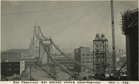 McCarthy Album 11, Photograph 326
 Caption: "San Francisco Bay Bridge Under Construction. Nov. 1, 1935." View of the towers and suspension cables of the western half of the San Francisco-Oakland Bay Bridge, spanning the distance between Yerba Buena Island in San Francisco Bay to the City of San Francisco. The bridge deck has not yet been completed. The Bay Bridge's design combined three different types of bridge-building technology over the five miles it covers between San Francisco and Oakland: a suspension span, a cantilevered span, and a tunnel. At the time of its completion in 1936, the bridge was the longest steel structure on the globe. It also featured the deepest bridge pier ever built, and the world's largest bore tunnel.
-
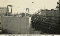 McCarthy Album 11, Photograph 325
 Caption: "San Francisco Bay Bridge Cable Anchorage. Nov. 1, 1935." View of a cable anchorage at one terminus of the San Francisco-Oakland Bay Bridge. The Bay Bridge's design combined three different types of bridge-building technology over the five miles it covers between San Francisco and Oakland: a suspension span, a cantilevered span, and a tunnel. At the time of its completion in 1936 the bridge was the longest steel structure on the globe. It also featured the deepest bridge pier ever built, and the world's largest bore tunnel.
-
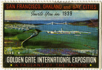 McCarthy Album 11, Photograph 324a
 No caption. Commemorative stamp celebrating the upcoming Golden Gate International Exposition, c. 1938. The Exposition, which ran from February through October in 1939 and May to September in 1940, celebrated the completion of the San Francisco-Oakland Bay Bridge (1936) and the Golden Gate Bridge (1937). More than ten million people attended in 1939, while an additional five million visited in 1940. The Exposition was held on an artificial island created by dredging more than 19 million cubic yards of material from the bottom of the bay. The federal government completed this dredging and fill, intending for the site, called Treasure Island, to become a municipal airport after the exposition. However, the advent of World War II resulted in the U.S. Navy taking over the site, holding it until for military purposes until 1997.
-
McCarthy Album 11, Photograph 324
Image withheld due to copyright considerations. For more information, please contact the California State Archives Reference Desk at ArchivesWeb@sos.ca.gov or (916) 653-2246. Double-sized panoramic postcard entitled "San Francisco-Oakland Bay Bridge, Golden Gate Bridge and Golden Gate International Exposition," c. 1938. Artist's rendering of San Francisco Bay, featuring the Golden Gate Bridge, the San Francisco-Oakland Bay Bridge, and the Golden Gate International Exposition.
-
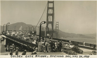 McCarthy Album 11, Photograph 323
 Caption: "Golden Gate Bridge, Opening Day, May 28, 1937." Dozens of automobiles are visible crossing the Golden Gate Bridge in this photograph, taken on the bridge's Opening Day, the first day that vehicular traffic was allowed over the bridge. Completed in 1937, the Golden Gate Bridge spans the mouth of San Francisco Bay (called the Golden Gate), connecting San Francisco with Marin County to the north. It is one of the most recognizable bridges in the world, and was named in 1994 as one of the Modern Wonders of the World by the American Society of Civil Engineers.
-
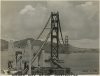 McCarthy Album 11, Photograph 322
 Caption: "Golden Gate Bridge Construction, July 1, 1936." View of the Golden Gate Bridge while under construction. The towers and suspension cables have been built, but the work on the bridge deck has not started. Completed in 1937, the Golden Gate Bridge spans the mouth of San Francisco Bay (called the Golden Gate), connecting San Francisco with Marin County to the north. It is one of the most recognizable bridges in the world, and was named in 1994 as one of the Modern Wonders of the World by the American Society of Civil Engineers.
-
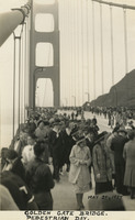 McCarthy Album 11, Photograph 321
 Caption: "Golden Gate Bridge. Pedestrian Day. May 27, 1937." View of crowds walking across the just-completed Golden Gate Bridge as part of Pedestrian Day. Pedestrian Day kicked off the Golden Gate Bridge Fiesta celebrating the opening of the now-iconic bridge. Approximately 200,000 people walked or roller-skated across the bridge during the Pedestrian Day festivities, held the day before the bridge opened to vehicular traffic.
-
 McCarthy Album 11, Photograph 320b
 No caption. Reverse of a souvenir ticket for the "Official Pedestrian Day" on May 27, 1937, held as part of the Golden Gate Bridge Fiesta celebrating the opening of the now-iconic bridge. The celebrations occupied an entire week, kicked off by Pedestrian Day, when more 200,000 people were allowed to walk across the Golden Gate Bridge on foot or on roller skates, the day before the bridge opened for vehicular traffic.
-
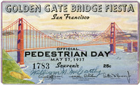 McCarthy Album 11, Photograph 320a
 No caption. Obverse of a souvenir ticket for the "Official Pedestrian Day" on May 27, 1937, held as part of the Golden Gate Bridge Fiesta celebrating the opening of the now-iconic bridge. The celebrations occupied an entire week, kicked off by Pedestrian Day, when more 200,000 people were allowed to walk across the Golden Gate Bridge on foot or on roller skates, the day before the bridge opened for vehicular traffic.
-
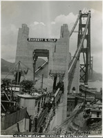 McCarthy Album 11, Photograph 320
 Caption: "Golden Gate Bridge, Construction, July 1, 1936." Image of one terminus of the Golden Gate Bridge, showing the anchoring site of the suspension wires. Completed in 1937, the Golden Gate Bridge spans the mouth of San Francisco Bay (called the Golden Gate), connecting San Francisco with Marin County to the north. It is one of the most recognizable bridges in the world, and was named in 1994 as one of the Modern Wonders of the World by the American Society of Civil Engineers.
-
McCarthy Album 11, Photograph 319
Image withheld due to copyright considerations. For more information, please contact the California State Archives Reference Desk at ArchivesWeb@sos.ca.gov or (916) 653-2246. Caption: "East Bay Span of S.F.-Oakland Bay Bridge, Nov. 12, 1938."
-
McCarthy Album 11, Photograph 318
Image withheld due to copyright considerations. For more information, please contact the California State Archives Reference Desk at ArchivesWeb@sos.ca.gov or (916) 653-2246. Caption: "San Francisco, Down Town and Bay Bridge. Feb. 1, 1938." Postcard showing what appears to be an artist's rendition of downtown San Francisco and the San Francisco-Oakland Bay Bridge.
-
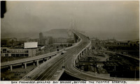 McCarthy Album 11, Photograph 317
 Caption: "Opening Day, Nov. 12, 1936, San Francisco, Oakland Bay Bridge, Before the Traffic Started." View of the San Francisco terminus of the San Francisco-Oakland Bay Bridge. Built between May 1933 and its opening on November 12, 1936, the Bay Bridge's design combined three different types of bridge-building technology over the five miles it covers between San Francisco and Oakland: a suspension span, a cantilevered span, and a tunnel. At the time of its completion the bridge was the longest steel structure on the globe. It also featured the deepest bridge pier ever built, and the world's largest bore tunnel.
-
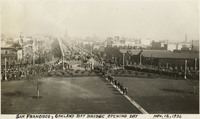 McCarthy Album 11, Photograph 316
 Caption: "San Francisco, Oakland Bay Bridge. Opening Day, Nov. 12, 1936." View of a portion of the ceremonies officially opening the San Francisco-Oakland Bay Bridge to traffic upon its completion in November 1936. The Bay Bridge's design combined three different types of bridge-building technology over the five miles it covers between San Francisco and Oakland: a suspension span, a cantilevered span, and a tunnel. At the time of its completion the bridge was the longest steel structure on the globe. It also featured the deepest bridge pier ever built, and the world's largest bore tunnel.
-
 McCarthy Album 11, Photograph 315
 Caption: "The China Clippers [sic] First Start Across the Pacific Ocean. Nov. 22, 1935." View of the China Clipper, a Martin M-130 four-engine flying boat constructed for Pan American Airways in 1935. One of the largest planes of its time, the China Clipper flew the first transpacific commercial airmail flight between San Francisco and Manila in the Philippines. The China Clipper was destroyed in a crash ten years later, in January 1945, at the Port of Spain, Trinidad and Tobago.
-
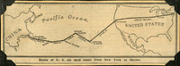 McCarthy Album 11, Photograph 314a
 No caption. Clipping from an unidentified newspaper or pamphlet entitled "Route of U.S. air mail route from New York to Macao." It shows an airmail route traveling from New York, west across the U.S. to the Hawaiian Islands, then to "Midway Islands," Wake Island, Guam, "Philippine Islands", and finally Macao, China.
-
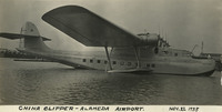 McCarthy Album 11, Photograph 314
 Caption: "China Clipper -- Alameda Airport. Nov. 22, 1935." View of the China Clipper, a Martin M-130 four-engine flying boat constructed for Pan American Airways in 1935. One of the largest planes of its time, the China Clipper flew the first transpacific commercial airmail flight between San Francisco and Manila in the Philippines. The China Clipper was destroyed in a crash ten years later, in January 1945, at the Port of Spain, Trinidad and Tobago.
-
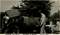 McCarthy Album 11, Photograph 313
 Caption: "Touring De Luxe. Dinner is Served. Oct. 10, 1934." William McCarthy serves part of a meal out of a metal box, with other boxes cooking more food on the engine of his Studebaker sedan. Grace McCarthy is seated to the right at a small folding table awaiting dinner.
-
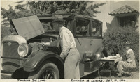 McCarthy Album 11, Photograph 312
 Caption: "Touring De Luxe. Dinner is Served. Oct. 10, 1934." William McCarthy is cooking a meal in metal boxes on the engine of his Studebaker sedan, while Grace McCarthy is seated to the right at a small folding table awaiting dinner.
-
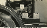 McCarthy Album 11, Photograph 311
 Caption: "Cooking Apparatus. One in Place on Motor, Two Removed. Oct. 10, 1934." This photograph shows three metal boxes used by the McCarthys for cooking during their five-month cross-country auto trip. One of the boxes is set on the engine of their automobile to heat the contents.
-
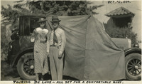 McCarthy Album 11, Photograph 310
 Caption: "Touring De Luxe -- All Set for a Comfortable Rest. Oct. 10, 1934." William and Grace McCarthy posing with posing with the automobile they traveled across the U.S. with, showing it set up for sleeping with a canvas pulled across the top and windows for privacy. The vehicle appears to be a Studebaker sedan, possibly dating from the mid-1920s.
-
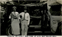 McCarthy Album 11, Photograph 309
 Caption: "Touring De Luxe -- Bed Made Up with Tent Rolled Back. Oct. 10, 1934." William and Grace McCarthy posing with the automobile they traveled across the U.S. with, showing it set up for sleeping with a canvas across the top for privacy. The vehicle appears to be a Studebaker sedan, possibly dating from the mid-1920s.
-
 McCarthy Album 11, Photograph 308
 Caption: "Touring De Luxe. Arranging Sleeping Quarters. Oct. 10, 1934." William McCarthy is arranging pads for sleeping in the car that the couple used to travel across the U.S. The vehicle appears to be a Studebaker sedan, possibly dating from the mid-1920s.
-
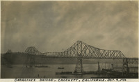 McCarthy Album 11, Photograph 307
 Caption: "Carquinez Bridge, Crockett, California. Oct. 9, 1934." This photograph shows the original Carquinez Bridge, built to span the Carquinez Strait and thereby contribute to a direct route between Sacramento and San Francisco. The steel cantilevered bridge, designed by Robinson & Steinman, was constructed in 1927. It is no longer extant, having been replaced by two parallel bridges constructed in 1958 and 2003. The structure of the original bridge was removed in 2007. See also 96-07-08-alb04-004.
-
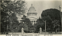 McCarthy Album 11, Photograph 306
 Caption: "State Capitol, Sacramento, Calif. Oct. 8, 1934." Construction began on the neoclassical California State Capitol Building, the dome of which is seen here (the rest of the building is largely obscured by trees), in 1860. Completed in 1874, the building still houses the state's legislature and the offices of the Governor.
-
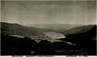 McCarthy Album 11, Photograph 305
 Caption: "Donner Summit, California. October 7, 1934." Panoramic view of Donner Lake and the surrounding mountains. A highway can be glimpsed running through the lower half of the photograph.
-
 McCarthy Album 11, Photograph 304
 Caption: "California Here We Come. Donner Monument. In Our Home State Again After Five Months Tour. October 7, 1934." William and Grace McCarthy took this photograph of the Pioneer Monument when they arrived back in California after a five month road trip to the East Coast. The Pioneer Monument, featuring a pair of pioneers with their two children looking west, was first dedicated on June 6, 1918 to commemorate those who emigrated to California in the mid 1800s. Today, the monument and surrounding area is known as Donner Memorial State Park. The park was established in memory of the ill-fated Donner Party, a group of emigrants whose wagon train was caught in the Sierra Nevada Mountains during the winter of 1846-47. The Pioneer Monument's stone pedestal stands twenty-two feet high, the height of the snow that the party had to contend with. Of the eighty-seven people in the wagon train, only forty-eight survived to be rescued the following spring. Some of the survivors are said to have resorted to cannibalism in order to survive.
-
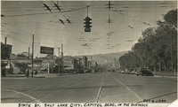 McCarthy Album 11, Photograph 303
 Caption: "State St. Salt Lake City. Capitol Bldg. in the Distance, Oct. 4, 1934." Street scene, with a wide road stretching toward the Utah State Capitol Building in the distance. Trolley tracks appear on the roadway, with wires overhead.
-
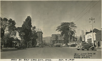 McCarthy Album 11, Photograph 302
 Caption: "Main St. Salt Lake City, Utah. Oct. 4, 1934. Salt Lake City is Noted for Clean Broad Streets." Street scene, with a wide roadway stretching into what appears to be a downtown area in the distance.
-
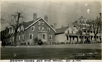 McCarthy Album 11, Photograph 301
 Caption: "Brigham Youngs [sic] Bee Hive House. Brigham Young had 19 Wives and 52 Children. Oct. 3, 1934." Street scene in Salt Lake City, Utah. Brigham Young, founder of the Church of Jesus Christ of Latter Day Saints built the so-called "Beehive House" in 1854 to house himself and several of his wives (Young practiced polygamy). The Beehive House is visible in the photograph at the far right, with a widow's walk featured on its roofline. Designed by Salt Lake Temple architect Truman O. Angell, the Beehive House has since been used as a residence for several dignitaries of the Mormon Church, as well as a boarding home for young Mormon women. The house was restored in the late 1950s and is now a museum. See also 96-07-08-alb11-301.
-
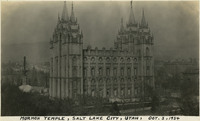 McCarthy Album 11, Photograph 300
 Caption: "Mormon Temple, Salt Lake City." View of the temple of the Church of Jesus Christ of Latter Day Saints (Truman O. Angell, architect) in Salt Lake City, Utah, dedicated in 1893. Portions of the surrounding areas of Salt Lake City can be seen in the background. See also 96-07-08-alb05-245.
-
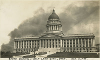 McCarthy Album 11, Photograph 299
 Caption: "State Capitol, Salt Lake City, Utah. Oct. 3, 1934." View of Utah's State Capitol Building, designed by Richard K.A. Kletting and built between 1912 and 1916.
-
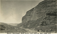 McCarthy Album 11, Photograph 298
 Caption: "Rocky Mountains Near State Line East of Salt Lake City. Trees are Scarce in the Rockies. Oct. 2, 1934." Automobile parked along a road, with train tracks on one side and dramatic, steep, rocky bluffs on the other.
-
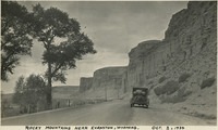
 McCarthy Album 11, Photograph 297
 Caption: "Rocky Mountains Near Evanston, Wyoming. Near Wyoming and Utah State Line. Oct. 2, 1934." A narrow road twists into the distance, flanked on one side by bottomland along a river or stream, and on the other by dramatic, steep, rocky bluffs.
-
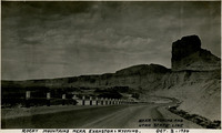
 McCarthy Album 11, Photograph 296
 Caption: "Rocky Mountains Near Evanston, Wyoming. Oct. 2, 1934." Automobile parked along a narrow road, flanked on one side by brush and trees in a field, and on the other by steep rocky bluffs.
-
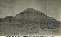 McCarthy Album 11, Photograph 295
 Caption: "Church Butte [sic], near Green River, Wyoming. Oct. 2, 1934." The Church Buttes in Wyoming consist of sandstone eroded by wind and weather into a butte approximately 1,000 feet in diameter and rising up to 100 feet above the surrounding valley floor. Located along the Overland Route used by emigrants to the West Coast, the formation gained additional notoriety for being a camp site for Brigham Young and the first Mormon party to head west, as well as a relay site for the Pony Express.
-
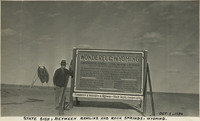 McCarthy Album 11, Photograph 294
 Caption: "State Sign, Between Rawlins and Rock Springs, Wyoming. Oct. 1, 1934." William McCarthy standing next to an informational road sign in Wyoming, noting the location as being along the U.S.'s primary Continental Divide.
-
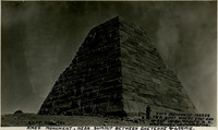 McCarthy Album 11, Photograph 293
 Caption: "This Monument Marks the Spot Where East and West Union Pacific R.R. Was Joined in Completion. Ames Monument, Near Summit Between Cheyenne & Larmie [sic]. Sept. 30, 1934." Grace McCarthy stands in front of the large four-sided pyramid of the Ames Monument in this photograph. The monument, designed by Henry Hobson Richardson, does not mark the spot where the transcontinental railroad was joined (that occurred at Promontory Summit in Utah). Instead, the Ames Monument commemorates brothers Oakes and Oliver Ames, financiers of the Union Pacific Railroad, builder of the eastern portion of the transcontinental railroad line. At the time the pyramid was constructed in 1882, it stood at the highest point in elevation attained by the transcontinental railroad (8,247 feet).
-
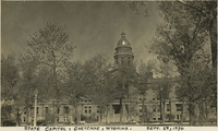 McCarthy Album 11, Photograph 292
 Caption: "State Capitol, Cheyenne, Wyoming. Sept. 29, 1934". Wyoming's State Capitol Building in Cheyenne was built between 1886 and 1890. Designed by the architectural firm David W. Gibbs & Company, the building features Renaissance Revival styling and elements.
-
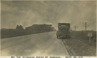 McCarthy Album 11, Photograph 291
 Caption: "On the Extensive Plains of Nebraska. Sept. 28, 1934." Automobile parked on the side of a highway stretching in to the distance, flanked by fields.
-
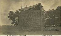 McCarthy Album 11, Photograph 290
 Caption: "A Nebraska Corn Bin, Many of These are Seen in Iowa and Eastern Nebraska. Sept. 27, 1934." A simple corn crib in Nebraska, where the corn ears are contained by wire fencing and sheltered by a gabled roof.
-
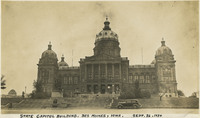 McCarthy Album 11, Photograph 289
 Caption: "State Capitol Building. Des Moines, Iowa. Sept. 26, 1934." Construction began on Iowa's State Capitol Building, designed by John C. Cochrane and Alfred H. Piquenard, in 1871, but was not completed until 1886. Mifflin E. Bell, an assistant to Piquenard, redesigned the central dome after Piquenard's death in 1876. Damage to the building's exterior over the years prompted a massive renovation project, begun in 1983 and completed in 2001.
-
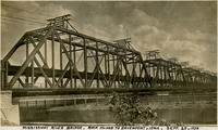 McCarthy Album 11, Photograph 288
 Caption: "Mississippi River Bridge. Rock Island to Davenport, Iowa. Sept. 25, 1934." View of the Government Bridge spanning the Mississippi River between Rock Island and Davenport, Iowa. Built in 1896 and designed by Ralph Modjeski, the bridge in this photograph was the fourth bridge constructed at the site, replacing earlier structures made obsolete by the increasing volume and changing character of traffic. This double-decker bridge connected the U.S. arsenal on Rock Island with Davenport, Iowa, and featured a double rail road track, a separate deck for automobiles, and a swing section. The bridge is still in use today.
-
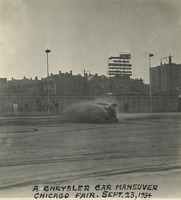 McCarthy Album 11, Photograph 287
 Caption: "A Chrysler Car Maneuver Chicago Fair. Sept. 23, 1934." A car appears to be rolling over in this photograph of the Chrysler Track at Chicago's Century of Progress Exposition. The Exposition, a world fair attended by thirty-nine million people, celebrated Chicago's one-hundred year anniversary of incorporation. Originally planned to only run from May to November in 1933, it was such a success that its organizers decided to keep it running for a second season from May through October the following year. The central theme of the Exposition was technological innovation, with a motto of "Science Finds, Industry Applies, Man Conforms."
-
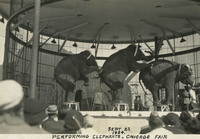 McCarthy Album 11, Photograph 286
 Caption: "Performing Elephants. Chicago Fair. Sept 23 1934." Three elephants performing in a circus ring at Chicago's Century of Progress Exposition. The Exposition, a world fair attended by thirty-nine million people, celebrated Chicago's one-hundred year anniversary of incorporation. Originally planned to only run from May to November in 1933, it was such a success that its organizers decided to keep it running for a second season from May through October the following year. The central theme of the Exposition was technological innovation, with a motto of "Science Finds, Industry Applies, Man Conforms."
-
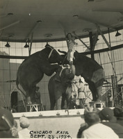 McCarthy Album 11, Photograph 285
 Caption: "Chicago Fair, Sept. 23, 1934." Three elephants performing in a circus ring at Chicago's Century of Progress Exposition. The Exposition, a world fair attended by thirty-nine million people, celebrated Chicago's one-hundred year anniversary of incorporation. Originally planned to only run from May to November in 1933, it was such a success that its organizers decided to keep it running for a second season from May through October the following year. The central theme of the Exposition was technological innovation, with a motto of "Science Finds, Industry Applies, Man Conforms."
-
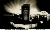 McCarthy Album 11, Photograph 284
 Caption: "Chicago Fair Grounds at Night. Sept. 22, 1934." View of a portion of the Century of Progress Exposition as seen at night. The Exposition, a world fair attended by thirty-nine million people, celebrated Chicago's one-hundred year anniversary of incorporation. Originally planned to only run from May to November in 1933, it was such a success that its organizers decided to keep it running for a second season from May through October the following year. The central theme of the Exposition was technological innovation, with a motto of "Science Finds, Industry Applies, Man Conforms."
-
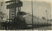 McCarthy Album 11, Photograph 283
 Caption: "Union Pacific Streamline Train. Chicago Fair. Sept. 22, 1934." View of the engine on the Union Pacific's new M-10000, on exhibit at Chicago's Century of Progress Exposition. The M-10000 was the first lightweight express passenger train powered by an internal combustion engine in the U.S. The train went on an exhibition tour of the US in 1934, which included a stop at the Exposition. The Exposition, a world fair attended by thirty-nine million people, celebrated Chicago's one-hundred year anniversary of incorporation. Originally planned to only run from May to November in 1933, it was such a success that its organizers decided to keep it running for a second season from May through October the following year. The central theme of the Exposition was technological innovation, with a motto of "Science Finds, Industry Applies, Man Conforms."